
 May 24, 2024
Acres: 1809
Start Date: 5/19/2024
Location: 7 miles north of the village of Coyote, N.M.
Personnel: 133
Containment: 0%
Fuels: Timber, litter, understory
Resources: 5 crews | 1 helicopter | 5 engines| 1 road grader | 2 masticators | 1 water tender
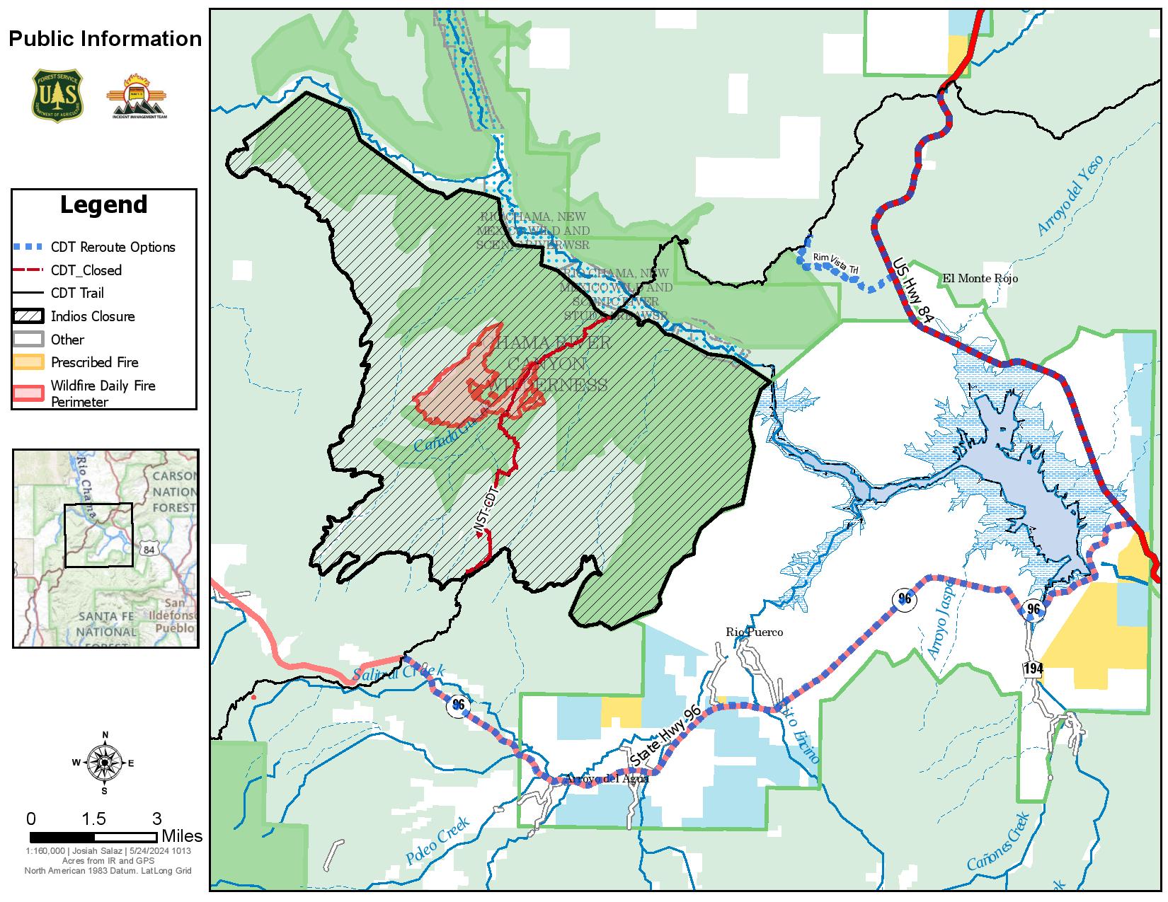
Highlights: Closure Order 03-10-01-24-02 is in place and includes all National Forest System lands within the boundary of the Coyote Ranger District starting from the Continental Divide trail #298 at Highway 96 going north across Forest Road (FR) 77, through the Chama River Canyon Wilderness to Skull Bridge (Ojitos Trail head) on FR 151. FR 11 northwest to the Chama River Canyon Wilderness boundary and Junction with FR 8; FR 169 (from junction with FR 11) south to FR 473; FR 473 south to FR 64; FR 64 South to the junction of FR 77; and FR 77 east to the Chama River Canyon Wilderness boundary. FR 77 from the Forest boundary and County Road 418 to the junction of FR 64 and FR 77. The Chama River Canyon Wilderness south of Rio Gallina and south of Rio Chama.
For CDT hikers impacted by this closure, camping will be available at the Coyote Ranger Station and water will be available.
Fire Activity: The fire continues to burn within the Chama River Canyon Wilderness in steep, inaccessible terrain. On Thursday, with near critical fire weather conditions, the fire grew as expected but is still within the larger potential perimeter. The fire spotted into the 2017 Ojitos Fire area yesterday. Today, two Interagency Hotshot crews and three engines will begin to work around this spot, anchoring into natural barriers and tying the line into the existing road systems. Fire managers continue to be strategic in their approach. While the helicopter was not used on the southern edge as initially planned, crews conducted some small but crucial strategic firing operations. These operations aimed to reduce fuels between FR 473 and the fire’s edge on the southwest perimeter. More firing operations are likely to be used. This will help minimize fire effects by using low to moderate intensity firing and reducing vegetation between lines and the main fire.
Local engines continued to hold, secure, and patrol along FR 473 further north. Two masticators progressed in Gamble Oak on the fire’s west side and got good depth on the lines in that area. The Mount Taylor and Black Mesa Interagency Hotshot Crews will begin work today, bringing the total number of IHCs to five.
Weather: Today, the high temperature will be around 72 degrees, and the minimum humidity will be 11-15 percent. Winds will be west 5-7 mph in the morning, increasing to 8-13 mph in the afternoon, with gusts to 25 mph. Wind trends will be stronger on Saturday, creating critical fire weather conditions despite the slight increase in humidity.
Smoke: Smoke is visible and local communities may experience smoke impacts along Highways 96, 112, and 84.
Closures: See today’s Highlights for current closure order information. Visit Inciweb for the full order and map.
Temporary Flight Restrictions: There is a TFR in place around the fire area.
More Information: 575-323-2290 | 2024.indios@firenet.gov | x.com/SantafeNF | facebook.com/santafeNF
inciweb.wildfire.gov/incident-information/nmsnf-indios-wildfire


Comments are closed.