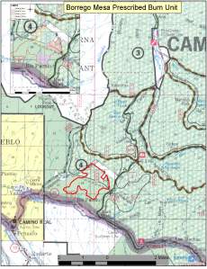
Home
About
Information
Fire Restrictions
Smoke Management
Links
Contacts
091718_Borrego Map
September 17, 2018
by
cnfpio
Comments Off
on 091718_Borrego Map
|
Full size is
1275 × 1662
pixels
091718_Bull Springs and Taos Pines Map
←
Camino Real District Announces Plan for Fall 2018 Prescribed Burns
Comments are closed.
Check Before You Go!
Weather.gov
SW Fire Restrictions Dashboard
Interagency all-risk incident information
Fire Maps
Fire Map Resources
Interactive National Fire Mapping Tool
Admin
Create account
Log in
Entries feed
Comments feed
WordPress.com
Blog Stats
24,349,020 hits
Subscribe
Subscribed
NM Fire Info
Join 2,368 other subscribers
Sign me up
Already have a WordPress.com account?
Log in now.
NM Fire Info
Subscribe
Subscribed
Sign up
Log in
Copy shortlink
Report this content
View post in Reader
Manage subscriptions
Collapse this bar
Comments are closed.