
 September 28, 2023
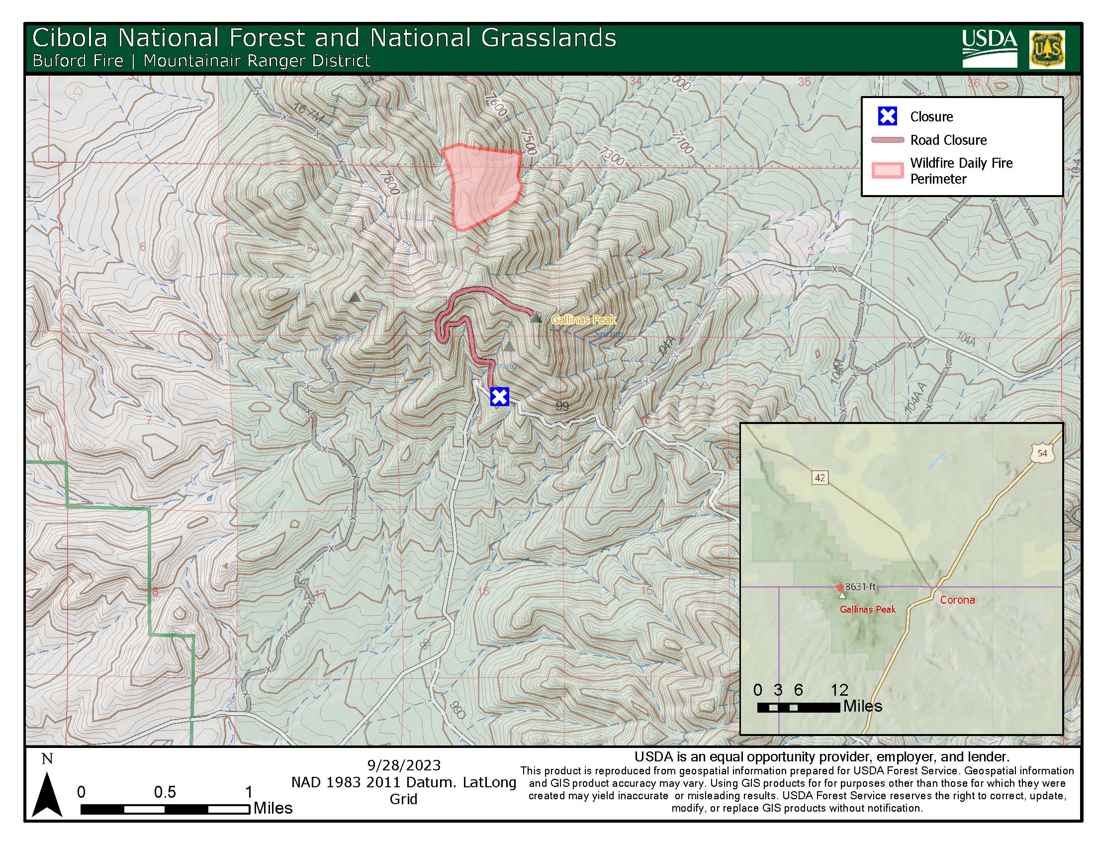
Mountainair Ranger District
Detection Date / Time: September 19, 2023 / 3 pm Cause: Lightning
Size: 108 acres Containment: 0% Total Personnel: 133
Location: Approximately 12 miles west of the village of Corona and 1 mile north of Gallinas Lookout. The fire is burning within the 2004 Lookout Fire burn scar in the Gallinas Unit of the Mountainair Ranger District.
Fire Behavior: Low to moderate with mostly backing and flanking and occasional isolated torching.
Fuels: Heavy to moderate dead and down, slash, Ponderosa Pine, grass and shrubs.
Strategy: The Buford Fire is being managed using a confine and contain strategy within a pre-determined perimeter on Forest Service land with a suppression strategy for private land inholding areas as long as conditions allow crews to safely do so. We use predictive services tools and fire behavior models to guide our fire management decisions. The benefit of this strategy will be to reduce hazardous fuels, encourage the growth of native plants, increase species diversity in the understory, restore ecological balance and reduce the potential for future high-severity wildfires.
Today’s Operations: Crews will finalize work and reinforcement along Forest Road 102 as well as old bulldozer lines all around the fire. This is in preparation for possible hand or aerial ignitions within the established planning area tomorrow (Friday) and possibly continuing into Saturday if necessary. This is to reduce the potential for rapid fire spread toward containment features. Crews will continue to assess the feasibility to implement a full suppression strategy around private land inholdings.
Wildlife biologists, range specialist and archaeologists are helping to ensure that natural and cultural resources are protected.
Resources On Scene: 5 Engines, 4 Bulldozers, 3 Water Tenders, 2 Type 1 Hotshot Crews, 1 Type 2 Initial Attack Crew, 1 Ambulance, 1 Type 3 Helicopter and various miscellaneous overhead.
Values at risk: Communication sites on Gallinas Peak and private land. There are no evacuations in effect.
Smoke will be visible from US Highways 60, 42 and 54.
Weather for Central NM: Today: Mostly Cloudy, temperatures 76-80°. West winds 6-10mph. Chance of showers 0%. Tonight: Mostly cloudy. Temperatures 51-55°. Winds Southwest 7mph. 0% chance of showers. Friday: Partly Cloudy, temperatures 73-77°. Southwest winds 8-12mph. Chance of showers 10%. weather.gov
Safety: The health and safety of firefighters and the public are always the first priority. Members of the public should stay away from fire operations.
Drones pose a serious risk to firefighting and can cause air operations to cease. The public is reminded that “If you fly, we can’t!”
Smoke-sensitive individuals and people with respiratory problems or heart disease are encouraged to take precautionary measures. Information on air quality and protecting your health can be found online at the New Mexico Department of Health (NMDOH) Environmental Public Health Tracking (EPHT) website nmtracking.org. An interactive smoke map is available at airnow.gov, which allows you to zoom into areas to see the latest smoke conditions.
All fire updates will be posted on the Cibola NF & NGs website, New Mexico Fire Information website, Inciweb and the Cibola NF & NGs Facebook & Twitter pages.
# # #
USDA is an equal opportunity provider, employer, and lender.


Comments are closed.