
 October 7, 2023
October 7 Update
Mountainair Ranger District
Detection Date / Time: September 19, 2023 / 3 pm Cause: Lightning
Size: 2358 acres Containment: 0% Total Personnel: 81
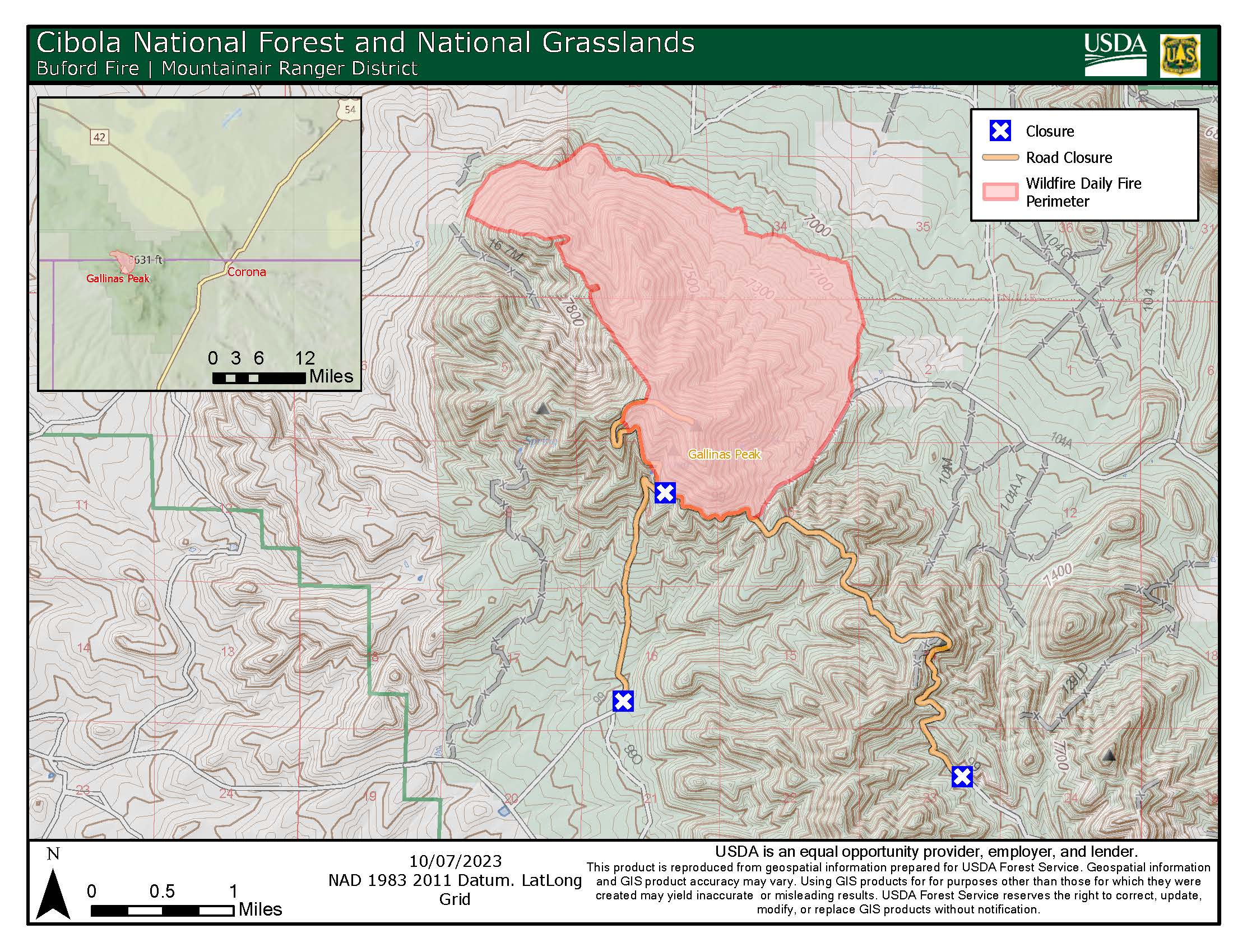
Location: Approximately 12 miles west of the village of Corona and 1 mile north of Gallinas Lookout. The fire is burning within the 2004 Lookout Fire burn scar in the Gallinas Unit of the Mountainair Ranger District.
Fire Behavior: Low to moderate with mostly backing and flanking and occasional isolated torching.
Fuels: Heavy to moderate dead and down, slash, Ponderosa Pine, grass and shrubs.
Strategy: The Buford Fire is being managed using a confine and contain strategy within a pre-determined perimeter on Forest Service land with a suppression strategy for private land inholding areas as long as conditions allow crews to safely do so. We use predictive services tools and fire behavior models to guide our fire management decisions. The benefit of this strategy will be to reduce hazardous fuels, encourage the growth of native plants, increase species diversity in the understory, restore ecological balance and reduce the potential for future high-severity wildfires.
Yesterdays and Today’s Operations: Other than a few minor unburned pockets within the interior, the majority of firing operations have ended on the Buford Fire. Crews will now concentrate on mop-up, rehabilitation and patrols around the fire. Containment numbers are expected to increase significantly in the next few days as firelines are secured. Crews have been successful in implementing a full suppression strategy around private land inholdings.
Wildlife biologists, range specialist and archaeologists are helping to ensure that natural and cultural resources are protected.
Resources On Scene: 4 Engines, 2 Bulldozers, 3 Water Tenders, 1 Type 1 Hotshot Crews, 1 Type 2 Initial Attack Crew, 1 Ambulance, 1 Type 3 Helicopter and various miscellaneous overhead.
Values at risk: Communication sites on Gallinas Peak and private land. There are no evacuations in effect.
Road Closure: The Cibola National Forest and National Grasslands (NF&NGs) has issued a road closure order (03-03-04-23-09) for National Forest System Road (NFSR) 102 from the junction with NFSR 99 (T1S R11W Sec. 4 and 9) to protect public health and safety in response to the staging of equipment and personnel to manage the Buford Fire. The order is in effect from September 28, 2023 at 00:01 through October 16, 2023 at 00:00, unless rescinded. The official order 03-03-04-23-09 posted on the Cibola NF & NGs website under Alerts & Notices. NFSR 99 may also close at times during firing operations.
Smoke will be visible from US Highways 60, 42 and 54. Smoke-sensitive individuals and people with respiratory problems or heart disease are encouraged to take precautionary measures. Information on air quality and protecting your health can be found online at the New Mexico Department of Health (NMDOH) Environmental Public Health Tracking (EPHT) website nmtracking.org. An interactive smoke map is available at airnow.gov, which allows you to zoom into areas to see the latest smoke conditions.
Weather for Central NM: Today: Mostly Sunny, temperatures 64-69°. Southwest winds 10mph shifting to south 10-20mph. Chance of showers 0%. Tonight: Partly cloudy. Temperatures 38-42°. Winds East 15-25mph. 0% chance of showers. weather.gov
Safety: The health and safety of firefighters and the public are always the first priority. Members of the public should stay away from fire operations.
Drones pose a serious risk to firefighting and can cause air operations to cease. The public is reminded that “If you fly, we can’t!”
All fire updates will be posted on the Cibola NF & NGs website, New Mexico Fire Information website, Inciweb and the Cibola NF & NGs Facebook & Twitter pages.
# # #
USDA is an equal opportunity provider, employer, and lender.


Comments are closed.