
 September 25, 2024
Magdalena, Mountainair, Sandia, Black Kettle and Kiowa Rita Blanca Ranger Districts
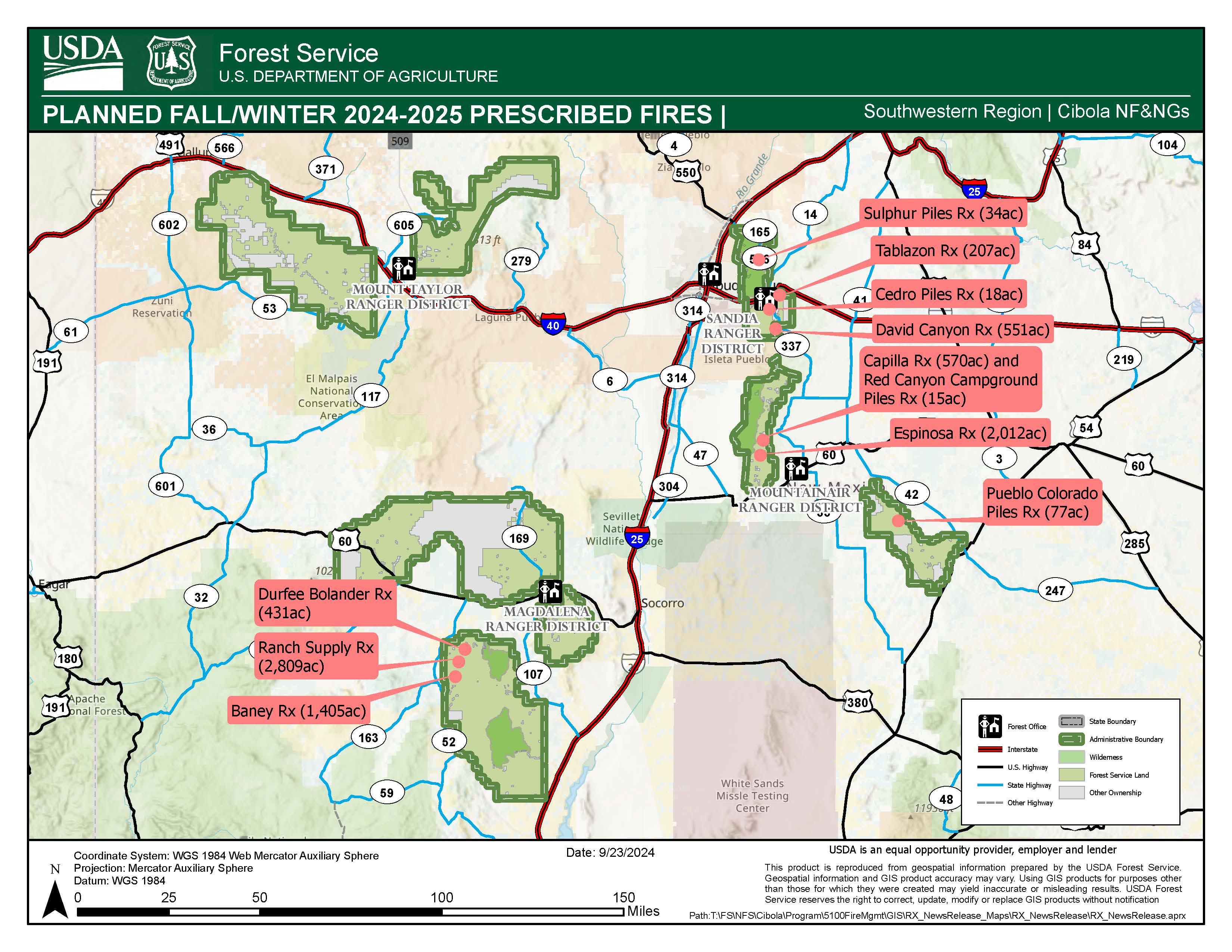
ALBUQUERQUE, NM – September 25, 2024 – The Cibola National Forest and National Grasslands (NF&NGs) fire crews are preparing to implement multiple prescribed fire projects as early as October 14 through the fall and winter months to reduce hazardous fuels as conditions allow. See attached map.
Prescribed fires are used to reduce the risk of high-severity wildfire by removing hazardous fuels, return nutrients to the soil and improve forest health. Fuels specialists write prescribed burn plans that identify – or prescribe – the best conditions under which trees and other plants will burn to get the best results safely. Among other factors, burn plans consider temperature, humidity, wind, moisture of the vegetation, smoke dispersal, monitoring, and resource availability.
With fire there is smoke, but firefighters take measures to reduce smoke impacts as much as possible. Fire crews use tactics such as starting early in the day and ending ignitions early in the afternoon to allow for the most ventilation possible throughout the burn, and dividing blocks into smaller units to minimize smoke impacts. However, smoke may be visible periodically from local communities for the duration of the project until the burning vegetation is out. The latest fire and smoke map and information on air quality and protecting your health can be found online at the http://www.airnow.gov/
Our land management strategy is centered on long-term forest health and that strategy includes reducing forest fuels and using prescribed fire on the landscape. A healthy forest is a resilient forest that experiences fire on a regular basis. After a prescribed fire is completed, if a future wildfire reaches this area, the fire behavior will likely be a less intense, more manageable surface fire due to the absence of accumulated debris and fuels.
Exact ignition dates for each prescribe fire operation are subject to change and will depend upon agency administrator approval and conditions within the ranges outlined in the project burn plan.
Mountainair Ranger District – Capilla Rx Fire: 570 acres of broadcast burning on the Capilla Fuels Reduction and Restoration Project in the Manzano Mountains located approximately 10 miles northwest of the town of Mountainair in the southern half of the Manzano Mountains, in Torrance County, NM. Smoke may be visible in the surrounding areas of Mountainair, Punta de Agua, Manzano, or the Estancia Valley.
Mountainair Ranger District – Espinosa Rx Fire: 2,012 acres of broadcast burning on the Espinosa-Barranco Wildlife Improvement Project in the Manzano Mountains, approximately 8 miles northwest of the town of Mountainair in the southern half of the Manzano Mountains, in Torrance County, NM. Smoke may be visible in the surrounding areas of Mountainair, Punta de Agua, Manzano, or the Estancia Valley.
Mountainair Ranger District – Red Canyon Campground Piles Rx Fire:15 acres of piles in the Hazard Tree Mitigation Project located adjacent to Upper Red canyon Campground in the Manzano Mountains, approximately 12 miles northwest of the town of Mountainair in the southern half of the Manzano Mountains, in Torrance County, NM. Smoke may be visible in the surrounding areas of Mountainair, Punta de Agua, Manzano, or the Estancia Valley.
Mountainair Ranger District – Pueblo Colorado Piles Rx Fire: 77 acres of piles in the Coordinated Resource Management Project in the Gallinas Mountains in Torrance County, NM. Located Southeast of Willard and 15 miles Northwest of Corona, NM. Smoke may be visible in the surrounding areas of Willard, Cedarvale, Corona or within the Estancia Valley.
Sandia Ranger District: Tablazon Rx Fire: 207 acres of broadcast burning in the Tablazon Canyon Area, in the Manzanita Mountains. Tablazon is located south of HWY 333, south of Lower Pine trailhead and east of FSRD 462. Smoke may be visible in the surrounding areas of Albuquerque, Tijeras, Edgewood and Moriarty, NM.
Sandia Ranger District: David Canyon Rx Fire: 551 acres of broadcast burning in the David Canyon area, in the Manzanita Mountains. David Canyon is located west of Hwy 337 and West of the Mars Court trailhead. Smoke may be visible in the surrounding areas of Albuquerque, Tijeras, Edgewood and Moriarty, NM.
Sandia Ranger District: Sulphur Piles Rx Fire: 34 acres of Piles within the Sulphur unit the Sandia Piles Rx plan. The pile burn area is in the Sandia east mountains, north of I-40, west of NM-14 and south of NM-536. Smoke may be visible in the surrounding areas of Albuquerque, Tijeras, Edgewood and Moriarty, NM.
Sandia Ranger District: Cedro Piles Rx Fire: 18 acres of Piles within the Cedro unit the Sandia Piles Rx plan. The pile burn area is in the Manzanita Mountains. Cedro is located south FSRD 462, east of HWY 337.
Magdalena Ranger District: Ranch Supply Rx Fire: 2,809 acres of broadcast burning in the vicinity of Point of Rock Canyon and along FSR 220. Smoke may be visible from the communities of Magdalena, Alamo, and Datil, NM.
Magdalena Ranger District: Durfee Bolander Rx Fire: 431 acres of broadcast burning in the vicinity of Morine Canyon. Smoke may be visible from the communities of Magdalena, Alamo, and Datil, NM.
Magdalena Ranger District: Baney Rx Fire: 1,405 acres of broadcast burning in the vicinity of Limestone Canyon along FSR 476 and FSR 549. Smoke may be visible from the communities of Magdalena, Alamo, and Datil, NM
Black Kettle National Grassland Ranger District: Broadcast Rx Fire of multiple blocks up to 2,500 acres across the district. Smoke may be visible from Roger Mills County, OK.
Kiowa Rita Blanca National Grasslands Ranger District: Broadcast Rx Fire burning of multiple blocks up to 2,500 acres across the district. Smoke may be visible from Clayton, New Mexico and Felt, OK.
Implementation announcements and updates on prescribed fire projects will be posted on InciWeb, New Mexico Fire Information and on the Cibola NF & NGs website, Cibola Facebook and Cibola Twitter sites.
Mt Taylor Ranger District Office: 505-287-8833
Magdalena Ranger District Office: 575-854-2281
Mountainair Ranger District Office: 505-847-2990
Sandia Ranger District Office: 505-281-3304
Black Kettle National Grassland District Office: 580-497-2143
Kiowa and Rita Blanca National Grasslands District Office: 575-374-9652
Cibola National Forest and National Grasslands Supervisor’s Office: 505-346-3900


Comments are closed.