Trout Fire Evening Update for June 15, 2025 

Communities urged to monitor evacuation status for Trout Fire 

Public meeting scheduled for 6:00 p.m. on Monday, June 16 

Fire Information Phone: 575-323-8964 (8 a.m. – 8 p.m.) 

Media Information Phone: 575-323-8984 (8 a.m. – 8 p.m.) 

Acres: 12,330 Start Date: June 12, 2025 

Location: 12 miles north of Silver City, NM Cause: Undetermined 

Personnel: 552 Fuels: Grass, brush and timber Containment: 0% 

Highlights: Southwest Area Incident Management Team 4 is working in tandem with local law enforcement and emergency management officials to ensure updated evacuation status information is readily available for communities impacted by the Trout Fire. Information and maps will be provided via InciWeb and the Gila National Forest Facebook. 

A public meeting is scheduled for 6:00 p.m. on Monday, June 16, 2025, at Grant County Business and Conference Center (3031 Highway 180, Silver City, NM). This meeting will be live streamed on the Gila National Forest (https://www.facebook.com/GilaNForest/). An account is not necessary to join the livestream. 

Fire Activity: Firefighters made steady progress on the Trout Fire today. In coordination with ground crews, aerial resources—including helicopters and air tankers—are conducting strategic water and retardant drops to slow the fire’s spread and reinforce containment efforts. Structure protection crews on the northern and eastern portions of the fire are actively installing hose lines and implementing structure protection measures within communities. Crews to the south and east are scouting and assessing the rugged terrain to identify natural barriers and holding features that can support and strengthen suppression efforts. At this time, the fire remains south of State Road 35 (NM 35). 

On Sunday afternoon, clouds moved into the region, helping moderate fire activity. Crews responded to and controlled several spot fires that crossed containment lines, including Meadow Creek Road into the Aztec Park area. Firing operations will continue throughout the night where needed in and around communities and along State Highway 15. These efforts aim to reduce fuel loads and create a buffer zone to slow the fire’s progression and help protect nearby communities. Resources will concentrate efforts on the northern, eastern, and southeastern portions of the fire. 

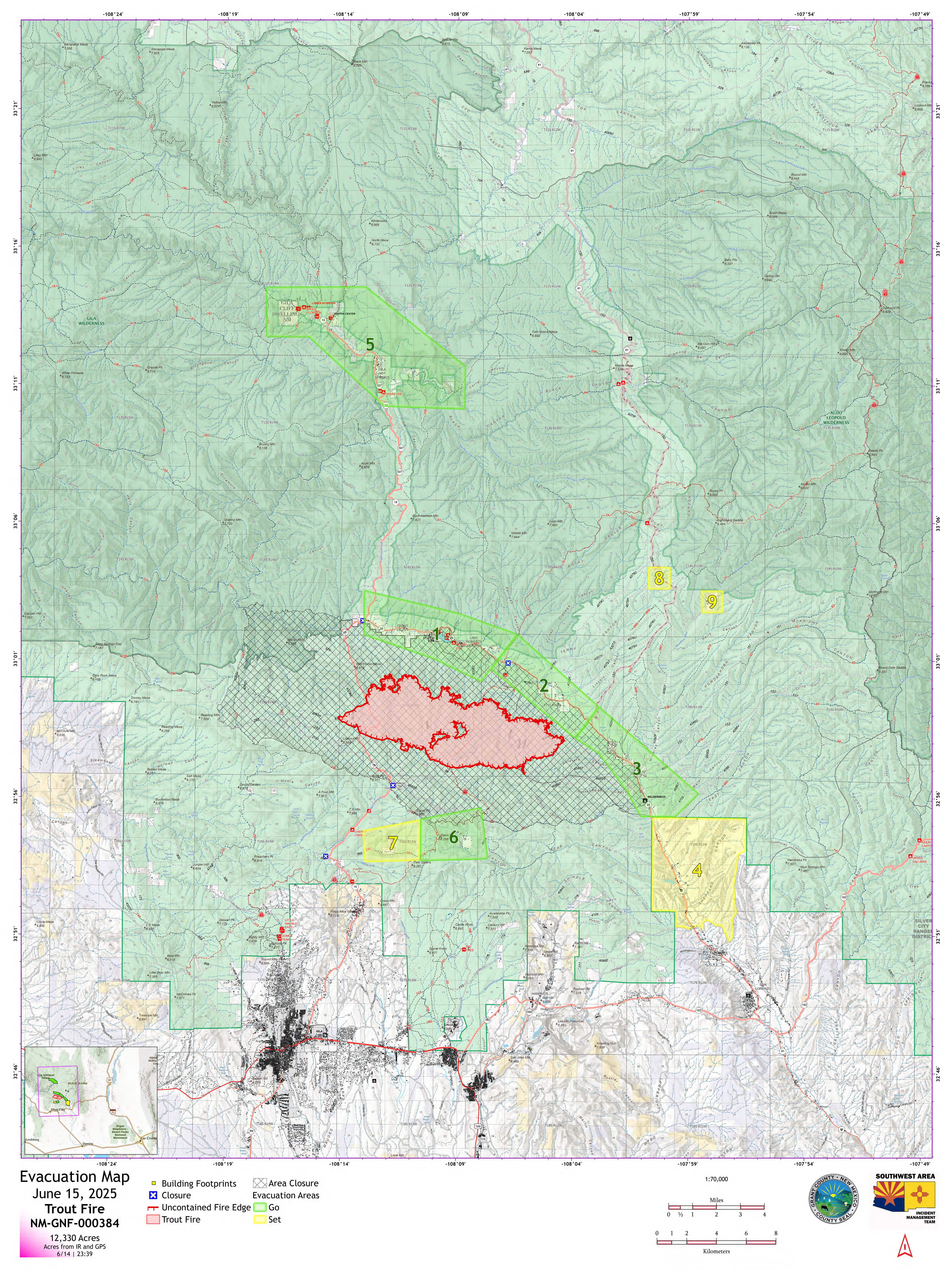
Evacuations: GO (Level 3) – Zones 1, 2, 3, 5, 6; SET (Level 2) – Zone 4, 7, 8, 9. Additional evacuation areas will be identified as the situation evolves. Maps are available on InciWeb. 

An evacuation shelter is available at the Convention Center in Silver City (3031 Highway 180 East, Silver City, NM). High Desert Humane Society will accommodate pets and the rodeo grounds at the Southwest Horseman’s Association are open to receive livestock. Weather: The high-pressure system over the region will begin to weaken on Monday. Temperatures will remain in the 90s with extremely low single-digit humidity and increased winds. 

Closures & Fire Restrictions: The Gila National Forest has issued a closure order for the area (https://www.fs.usda.gov/r03/gila/alerts/trout-fire-area-closure). Stage 2 Fire Restrictions are also in place (https://www.fs.usda.gov/r03/gila/alerts/stage-2-fire-restrictions) and a Temporary Flight Restriction (TFR) is in effect (https://tfr.faa.gov/tfr3/?page=detail_5_3951). 

More Information: 

InciWeb: https://inciweb.wildfire.gov/nmgnf-trout-fire
Facebook: https://www.facebook.com/GilaNForest
Email: 2025.trout@firenet.gov

Image has black text on white background and reads: Área Suroeste
Equipo de Gestión de Incidentes
EQUIPO 4 - Andrew Mandel - COMANDANTE DE INCIDENTES
Se insta a las comunidades a vigilar el estado de la evacuación por el incendio Trout
Reunión pública prevista para el lunes 16 de junio a las 6 p.m.
Actualización de la tarde del 15 de junio de 2025
Teléfono de información de incendios: 575-323-8964 (8 a.m. – 8 p.m.)
Información de medios de comunicación: 575-323-8984 (8 a.m. – 8 p.m.)
Acres: 12,330 Fecha de inicio: 12 de junio de 2025
Localización: 12 millas al norte de Silver City, NM Causa: Bajo investigación
Personal: 552 Combustibles: Hierba, maleza y árboles
Contención: 0%
Aspectos destacados: El Equipo 4 de Gestión de Incidentes del Área Suroeste está trabajando conjuntamente con las fuerzas de seguridad locales y los funcionarios de gestión de emergencias para garantizar que las comunidades afectadas por el incendio de Trout dispongan de información actualizada sobre el estado de la evacuación. La información y los mapas se proporcionarán a través de InciWeb y el Facebook del Bosque Nacional de Gila.
Una reunión pública está programada para las 6:00 p.m. el lunes, 16 de junio de 2025, en Grant County Business and Conference Center (3031 Highway 180, Silver City, NM). Esta reunión será transmitida en vivo en el Gila Bosque Nacional. (https://www.facebook.com/GilaNForest/). No es necesario tener una cuenta para participar en la retransmisión en directo.
Actividad del fuego: Los bomberos hicieron progresos constantes en el incendio de Truchas hoy. En coordinación con los equipos de tierra, los recursos aéreos - incluyendo helicópteros y aviones cisterna - están llevando a cabo estratégica de agua y retardante gotas para frenar la propagación del fuego y reforzar los esfuerzos de contención. Los equipos de protección de estructuras en las partes norte y este del incendio están instalando líneas de mangueras y aplicando medidas de protección de estructuras en las comunidades. Las cuadrillas situadas al sur y al este están explorando y evaluando el terreno accidentado para identificar barreras naturales y elementos de contención que puedan apoyar y reforzar las labores de extinción. En este momento, el fuego permanece al sur de la carretera estatal 35 (NM 35).
El domingo por la tarde, las nubes se adentraron en la región, ayudando a moderar la actividad del fuego. Las cuadrillas respondieron y controlaron varios incendios puntuales que cruzaron las líneas de contención, incluyendo Meadow Creek Road en el área de Aztec Park. Las operaciones de fuego continuarán durante toda la noche donde sea necesario en y alrededor de las comunidades y a lo largo de la carretera estatal 15. Estos esfuerzos tienen como objetivo reducir la carga de combustible y crear una zona de amortiguación para frenar la progresión del fuego y ayudar a proteger a las comunidades cercanas. Los recursos se concentrarán en las partes norte, este y sureste del incendio.
Evacuaciones: GO (Nivel 3) - Zonas 1, 2, 3, 5, 6; SET (Nivel 2) - Zonas 4, 7, 8, 9. Se determinarán otras zonas de evacuación a medida que evolucione la situación. Los mapas están disponibles en InciWeb.
Un refugio de evacuación está disponible en el Centro de Convenciones en Silver City (3031 Highway 180 East, Silver City, NM). La High Desert Humane Society acogerá a los animales de compañía y los terrenos del rodeo de la Southwest Horseman's Association están abiertos para recibir al ganado.
Tiempo: El sistema de altas presiones sobre la región comenzará a debilitarse el lunes. Las temperaturas se mantendrán en los 90 con una humedad extremadamente baja de un solo dígito y un aumento de los vientos.
Cierres y restricciones de incendios: El Bosque Nacional de Gila ha emitido una orden de cierre para la zona (https://www.fs.usda.gov/r03/gila/alerts/trout-fire-area-closure). También se han establecido restricciones de incendios de fase 2 (https://www.fs.usda.gov/r03/gila/alerts/stage-2-fire-restrictions) y una restricción temporal de vuelos (TFR) (https://tfr.faa.gov/tfr3/?page=detail_5_3951).
Más información:
InciWeb: https://inciweb.wildfire.gov/nmgnf-trout-fire
Facebook: https://www.facebook.com/GilaNForest Correo electrónico: 2025.trout@firenet.gov
Image is a mint green color with darker and lighter shades plus shapes filled with green and yellow and red.

Comments are closed.