
 January 23, 2026
Favorable weather conditions must be in place for hazardous fuels reduction work
ALBUQUERQUE, NM – January 23, 2026 – The Cibola National Forest and National Grasslands are preparing to strategically implement multiple prescribed fires in the coming weeks across the forest and grasslands.
We estimate this work to continue through the remaining winter months into spring as weather conditions allow. Prescribed (Rx) fire helps reduce overgrown vegetation to protect local communities, infrastructure and natural resources from catastrophic wildfires.
Numerous projects are anticipated; however the exact days of ignitions will depend on wind, weather, fuel moisture conditions and required approvals.
Prescribed fires planned as early as January 26:
Magdalena Ranger District:
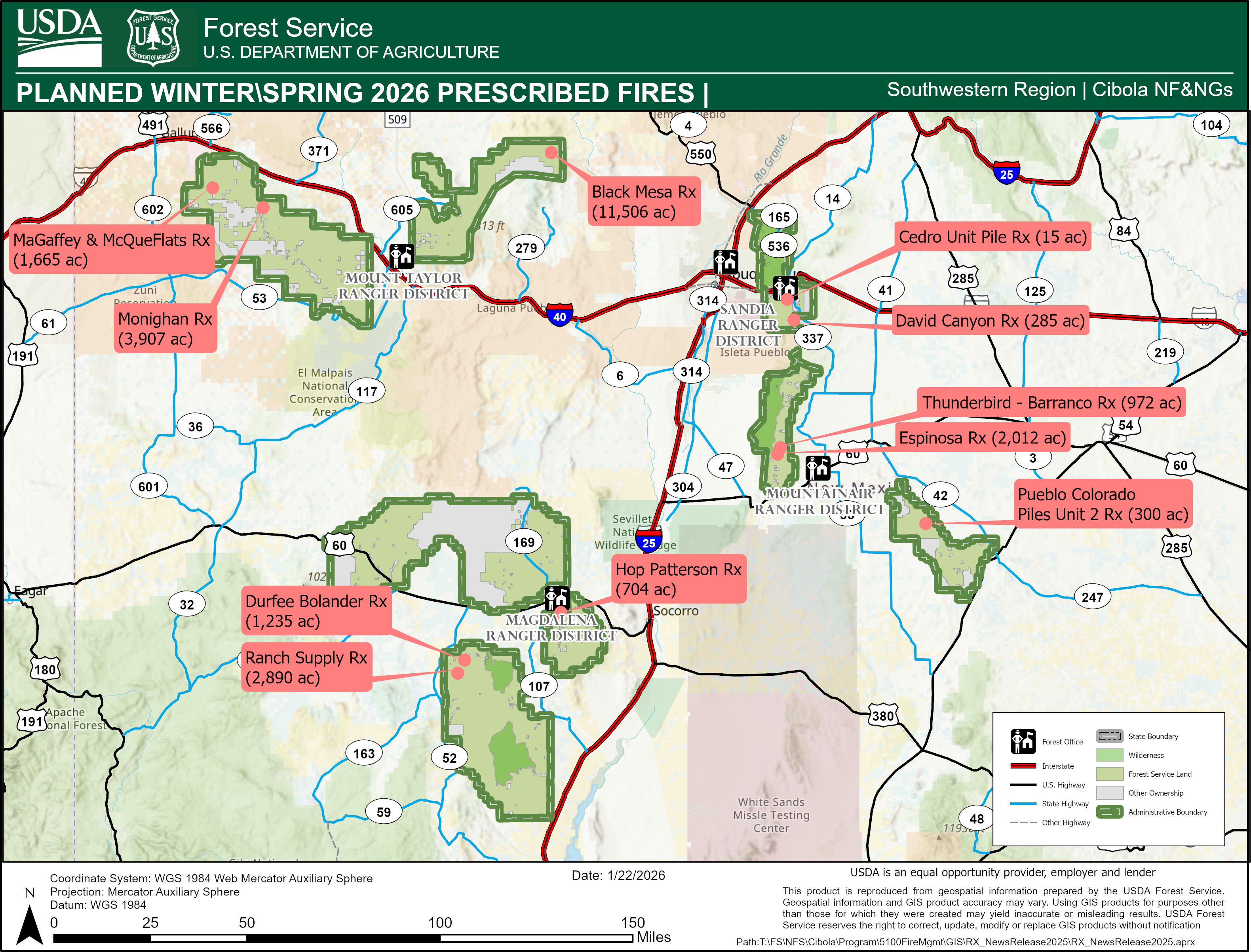
- Hop Patterson Prescribed Fire: 704 acres of broadcast and pile burning units located 3 miles south of Magdalena and adjacent to the communities of Hop and Patterson Canyon. Smoke may be visible from Magdalena and Alamo.
Mountainair Ranger District:
- Pueblo Colorado Prescribed Pile Fire Unit 2. Up to 300 acres of piles in the Coordinated Resource Management Project in the Gallinas Mountains in Torrance County, NM. Located Southeast of Willard and 15 miles Northwest of Corona, NM. Smoke may be visible from Willard, Cedarvale, Corona or within the Estancia Valley.
Prescribed fires planned through winter into spring include:
Mt Taylor Ranger District:
- Monighan RX Fire: 3,907 acres broadcast burning on the Bluewater Project is approximately 27 miles west of Grants and 13 miles Southeast of Ft. Wingate NM within Zuni Mountains of Cibola National Forest. Smoke may be visible in the surrounding area of Ramah, Gallup, Thoreau, Bluewater, Grants and Millan.
- Black Mesa RX Fire: 11,506 acres broadcast burning on the Black Mesa Wildlife Habitat Improvement Project 20 miles North of Grants, NM in Mckinley, and Sandoval Counties of Cibola National Forest. Smoke may be visible in the surrounding area of the surrounding areas of Grants, Albuquerque, Cuba, Jemez, NM 550, and possible I-40.
- McGaffey and McQue Flats Rx (1,665 Acres) broadcast burning on the Puerco Project is approximately 63 miles from Grants and 13 miles Southeast of Ft. Wingate NM within Zuni Mountains of Cibola National Forest. Smoke may be visible in the surrounding area of Ramah, Gallup, Thoreau, Bluewater, Grants and Millan.
Magdalena Ranger District:
- Ranch Supply Rx Fire: 2,890 acres of broadcast burning in the vicinity of Old Canyon, Ranch Supply Canyons, Point of Rocks Canyon and along FSR 220. Smoke may be visible from Magdalena, Alamo, and Datil, NM.
- Durfee Bolander Rx Fire: 1,235 acres of broadcast burning in the vicinity of Bolander Canyon along both sides of FSR 220 near the junction of FSR 220 and FSR 549. Smoke may be visible from Magdalena, Alamo, and Datil, NM.
Mountainair Ranger District:
- Espinosa Prescribed Fire: 2,012 Acres of broadcast burning located on the Espinosa-Barranco Wildlife Improvement Project in the Manzano Mountains, approximately 8 miles northwest of the town of Mountainair in the southern half of the Manzano Mountains, in Torrance County, NM. Smoke may be visible from Mountainair, Punta de Agua, Manzano, and the Estancia Valley.
- Thunderbird-Barranco Prescribed Fire: 972 Acres of broadcast burning located North of the Espinosa Prescribed Fire and south of FSR 275 in the Manzano Mountains, approximately 8 miles northwest of the town of Mountainair in the southern half of the Manzano Mountains, in Torrance County, NM. Smoke may be visible from Mountainair, Punta de Agua, Manzano, and the Estancia Valley.
Sandia Ranger District:
- David Canyon Prescribed Fire: 285 acres of broadcast burning in the David Canyon area, in the Manzanita Mountains. David Canyon is located west of Hwy 337 and West of the Mars Court trailhead. Smoke may be visible from Albuquerque, Tijeras, Edgewood and Moriarty, NM.
- Cedro Unit Prescribed Pile Burn: 15 acres of piles within the Cedro unit in the Sandia Piles Rx plan. The pile burn area is in the Manzanita Mountains. Cedro is located south FSRD 462, east of HWY 337. Smoke may be visible from Albuquerque, Tijeras, Edgewood and Moriarty, NM.
Kiowa & Rita Blanca National Grasslands:
- 3,000 acres of multiple units of prescribed fire broadcast burning across the district. Smoke may be visible from Clayton, Roy, Springer NM and Felt, OK.
Black Kettle & McClellan National Grasslands:
- 3,000 acres of multiple units of prescribed fire broadcast burning across the district. Smoke may be visible from Roger Mills County, OK.
These areas may close during project implementation for public safety. Watch for warning signs along roads near all prescribed fire areas before and during burns.


Comments are closed.