
 May 12, 2022
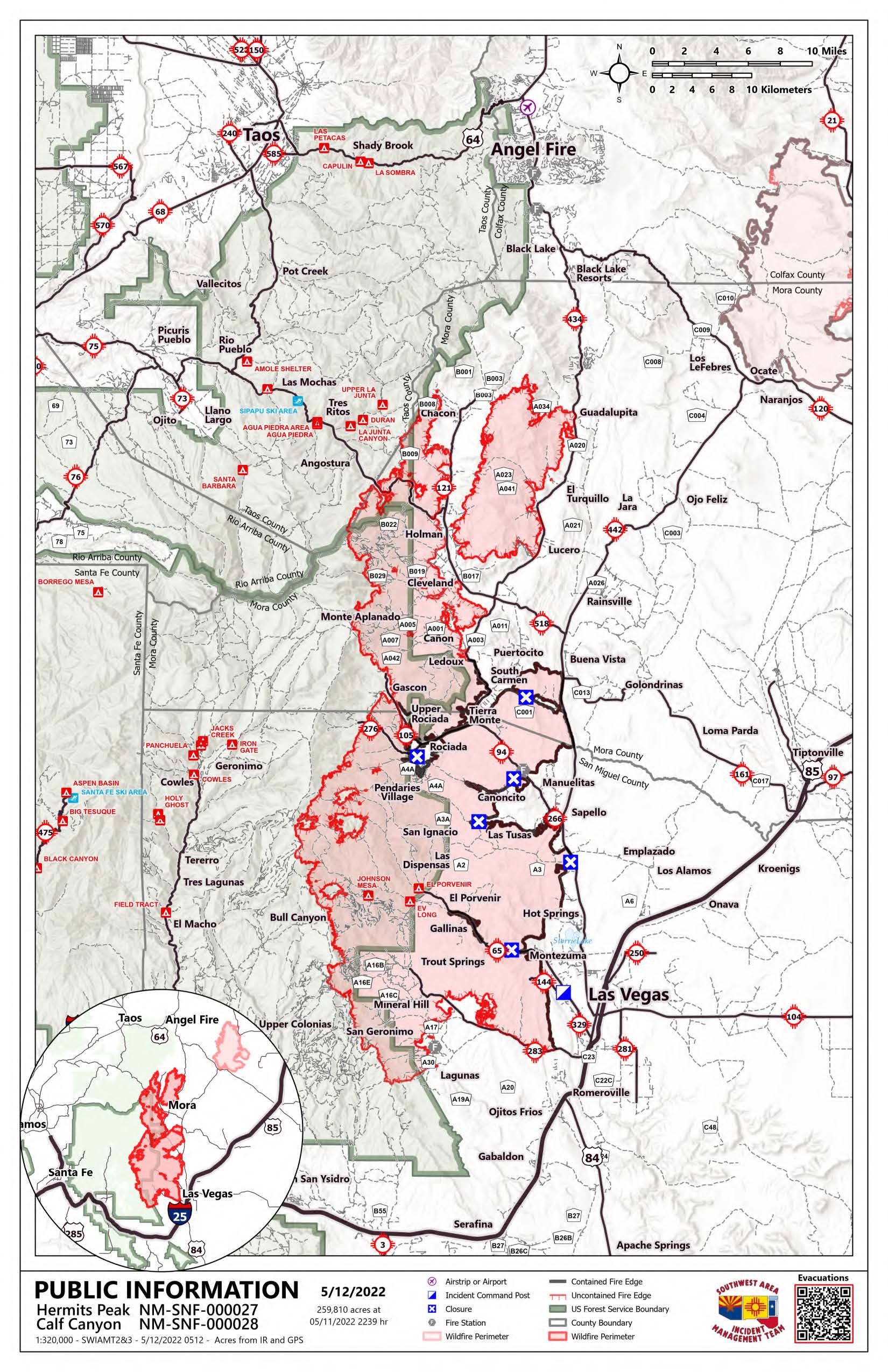
| Acres: 259,810 acres – Containment: 29% – Total personnel: 1,859 Start Date: Hermits Peak: April 6, 2022; Calf Canyon: April 19, 2022 Cause: Hermits Peak: spot fires from prescribed burn; Calf Canyon: under investigation Location: Located near Gallinas Canyon – Fuels: Heavy mixed conifer, ponderosa pine, brush, and grass |
Highlights: This fire is going to keep growing, and more firefighters, heavy equipment operators, support crews, and incident command teams are being ordered. The weather has been unfavorable for weeks, and another Red Flag Warning is in place from 9:00 AM to 8:00 PM. This will continue to cause extreme fire behavior and rapid growth, especially to the north. Much of the fire’s growth is in thick, heavy timber and steep, rugged terrain. Spotting distances could be as far as ½ to ¾ of a mile today. Structure protection crews are moving into new communities likely to be impacted. Yesterday aircraft flew throughout the day. However, they were grounded at times on the south due to winds and on the north due to poor visibility. They plan to be active today as conditions allow. The Temporary Flight Restriction is now 70 miles long and applies to all drones and aircraft not working the fire. Residents of San Miguel, Mora, Taos, and Colfax counties should remain on high alert for changes to evacuation statuses and road closures.
Operations: With lots of fire over Highway 518 and spreading rapidly, day and night crews are conducting defensive firing operations to reduce fuels ahead of the fire and around homes. Structure protection groups comprised of hand crews, dozers, and engines are still working in the Highway 518, 121, 434, 442 corridors and canyon communities. They are moving further north into communities up to Black Lake and west around Angostura. Fire leadership is working with landowners around Black Lake to scout and locate features like roads to tie lines together and formulate a plan with the highest probability of success. The east side from Ledoux to Las Vegas looks good. Some visible interior pockets of fuel continue to burn out but pose no threat to containment lines. On the south, firelines have held, and the winds are pushing the fire back into itself. Structure protection groups are still working in the area. On the southwest, the fire is backing into the wind, resulting in low rates of spread. More firefighters have been moved to work around Barillas Peak. On the Pecos side, crews are constructing firelines, fighting fire direct where possible, and getting familiar with the terrain and values at risk for developing other strategies. Structure protection crews are working in Upper and Lower Colonias and Bull Canyon if the fire moves in those directions. Around Rociada, firefighters battled fire in an area that flared up yesterday. Crews continue protecting structures, conducting defensive firing operations, and securing the fire’s edge in that area. The fire is still moving into the Pecos Wilderness towards Lone Pine Mesa, Blue Bell Ridge, and further north near Enchantment Lake.
Evacuations: For an interactive map collection, including the evacuation map, scan the QR code at the top of the page or go to https://tinyurl.com/HermitsPeak. Follow Taos County (https://www.facebook.com/profile.php?id=100064642843163), San Miguel County (www.facebook.com/smcso.nm), and Mora County (www.facebook.com/moracountysheriffoffice) Sheriff’s Office Facebook pages for the latest updates.
Weather: On the southern end, winds west to southwest 28 to 32 mph with gusts to 45. In the Mora River Valley, west winds 15 to 20 mph with gusts to 30. Maximum temperatures lower 60’s to mid-70’s. Minimum relative humidity 5 to 14%.
Restrictions: A new Carson National Forest closure order includes the entire Camino Real Ranger District. Forest-wide Stage 2 fire restrictions have been implemented. Full closure order and map: www.fs.usda.gov/alerts/carson/alerts-notices
The Santa Fe National Forest closure order includes the entire Pecos/Las Vegas Ranger District. Forest-wide Stage 2 fire restrictions have been implemented. Full closure order and map: www.fs.usda.gov/detail/santafe/alerts-notices/?cid=stelprd3802009.
Smoke: An interactive smoke map at https://fire.airnow.gov/ allows you to zoom into your area to see the latest smoke conditions.
Fire Information: The Hermits Peak and Calf Canyon Fires Information office hours are 8:00 AM – 8:00 PM. The phone number for fire information is 505-356-2636. The email address is 2022.hermitspeak@firenet.gov. Official fire information is posted on Inciweb (inciweb.nwcg.gov/incident/8069/) the SFNF Facebook and Twitter, SFNF website, and New Mexico Fire Information website.


Comments are closed.