
 June 9, 2022
Another Heads-Up Day Due to Weather
Community Meeting Tonight at 6 pm in Kingston
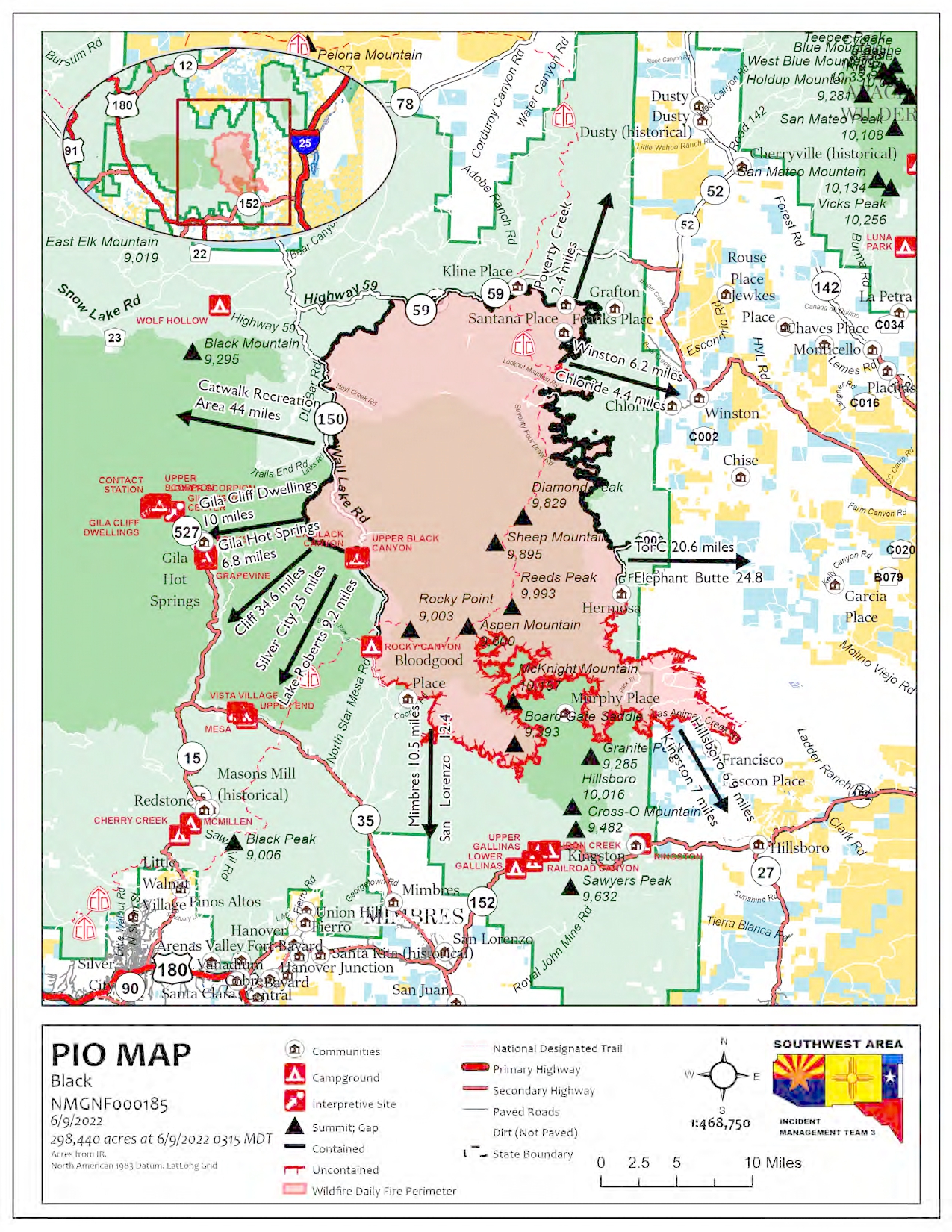
Acres: 298,440 acres
Containment: 44%
Personnel: 918
Location: 31 miles NW of Truth or Consequences, NM
Start Date: Friday, May 13, 2022
Cause: Human-caused, under investigation
Fuels: Timber and tall grass
Structures Lost: 2
New Road Closures: NM 152 will be closed starting at 8 a.m., from mileposts 40 (Kingston) to milepost 15 (San Lorenzo). No entry will be allowed.
NM Hwy 59 “Beaverhead Road” will remain closed to traffic from Forest Road 150 to NM Hwy 52 between the hours of 8:00 a.m. to 6:00 p.m. to provide safety for firefighters working along the roadway. The NM Hwy 59 will be open to traffic between the hours of 6:00 p.m. to 8:00 a.m. A portion of the Gila National Forest affected by the fire has been closed.
To learn about the current evacuation status for the Black Fire, please access the real-time, interactive evacuation map. or contact your local jurisdiction’s emergency management agencies.
The current weather pattern is increasing humidity levels, but lightning strikes and gusty winds are a concern. Yesterday, firefighters were pulled off the fire line for a while to take shelter from the lightning. Firefighters also responded to two new fires located near Emery Pass that were started by lightning strikes.
Firefighter resources continue to arrive, including a helicopter rappelling firefighter crew who will access Mineral Creek to assess isolated heat sources and work on fire suppression. Firefighters continue to monitor and patrol the fire along the existing containment lines. Structure assessments have been completed in Ladder Ranch and chipping operations continue along Highway 152. Aluminum wrap has been placed on a communication tower near Emory Pass for protection. Aircraft will be used as weather conditions allow.
Weather: Scattered thunderstorms will form again over the fire by the later morning and will continue into the evening. This is followed by another night of mostly terrain driven winds and decent relative humidity recoveries. Thunderstorm chances will continue into the weekend. THUNDERSTORMS IMPLY STRONG GUSTY DOWNDRAFT WINDS!
Aviation Restrictions: The Temporary Flight Restriction (TFR) which restricts non-fire aircraft over the Black Fire has been expanded to the south and east. This includes civilian drones. Unauthorized aircraft in the area can ground firefighting aircraft, hinder firefighting efforts, and can also result in criminal charges for the offender.
Fire Restrictions: Know Before You Go! The public can obtain current state and federal fire restriction information across New Mexico at NM Fire Info | Fire Restrictions or at NM Forestry Division state-wide fire restrictions: https://www.emnrd.nm.gov/sfd/find-current-fire-restrictions/
More Information:
• InciWeb: https://inciweb.nwcg.gov/incident/8103/
• Facebook: https://www.facebook.com/GilaNForest
• New Mexico Fire Information: https://nmfireinfo.com/
• Twitter: https://twitter.com/gilanforest
• New Mexico Road Information: https://www.nmroads.com/
• Smoke Outlook Report: https://outlooks.airfire.org/outlook/dde9ec52
• Sierra County: https://www.sierraco.org/department/emergency-management/
• Catron County: https://www.catroncounty.us/departments/fire_chief/
• Grant County: https://grantcountynm.gov/departments/emergency-management/
• Firewise: https://www.emnrd.nm.gov/sfd/fire-prevention-programs/firewise-usa/


Comments are closed.