
 May 6, 2023
Update 10:30 a.m. 5/6/23: All lines held through yesterday’s wind event and through the evening. Containment this morning is 50%. This will be the last notification unless significant changes occur.
Update 9:30 a.m. 5/5/23: The Park fire showed no overnight growth after this morning’s reconnaissance. Acreage remains at 3,000. Today, crews will be focusing on holding secured lines through today’s red flag conditions.
Yesterday’s air attack and slurry proved effective in boxing the fire spread. The fire burned actively all day, with torching junipers and short runs. Crews were able to successfully burn out to help secure the uncontained north line and create additional black by the evening.
Local VFD personnel were released for rest and rehabilitation and availability for response to any new incidents within their jurisdiction. 70 personnel are engaged, with Forestry Division, Wildfire Response Program, tribal and federal resources managing the incident.
Today’s forecast calls for a warming trend with higher temperatures and lower relative humidity. Winds are expected to gust from the southwest over 20 mph. Currently, there are no air quality alerts to report in the area.
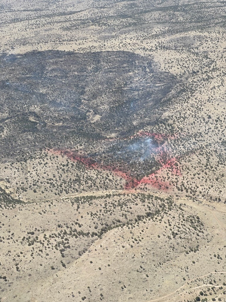
Effects of slurry on containment edges
Update 2 p.m., 5/4/23: Winds have picked up to the expected speeds of 30 mph, with gusts ranging up to 35 mph causing the fire to spread in a northeast direction. Additional slurry has been ordered for air attack. The relative humidity has dropped to 19%, and the temperature has risen slightly to 66 degrees.
First 11:40 a.m.5/4/23: The Park fire continues to burn south of Hondo, in Lincoln County, and is at zero percent containment with an acreage of 3000. It is burning through grass and pinyon/juniper fuels.
State, local and tribal agencies responded after the fire’s discovery Wednesday, May 3 at 11 a.m. Arroyos presented topographical issues with containment, but the relative humidity increase in the evening provided a boon to firefighters.
Today, crews continue to work on containment edges. Burnouts along the Mescalero fence line have kept the fire from progressing onto reservation land. An air tanker has been able to effectively check the spread with retardant once fire activity picked up on the southeast side. Winds are gusting from the southwest at 23 mph, with a predicted rise to 30 mph later in the day. No structures have been lost and none are currently threatened.
**
Start Date & Time: 05/03/2023 @ 1100
Start Location: South of Hondo, East of Mescalero Reservation boundary.
Latitude: 33.29695
Longitude: -105.3009
Cause of Fire: Lightning
Area Vegetation: grass, pinyon/juniper
Estimated Acres Burned: 3000
Ownership(s): Private/ near Mescalero boundary
Structures Threatened: No
Structures Burned: No
Evacuations: No
—
George Ducker
Communications Coordinator
New Mexico State Forestry Division – EMNRD


Comments are closed.