
 May 13, 2026
Crews begin to secure direct line and establish anchor points
Albuquerque Zone Incident Management Team
Fire Information Phone: 575-210-8631 (8 a.m.– 8 p.m.)
Acres: 341
Start Date: May 8, 2026
Cause: Undetermined
Personnel: 249
Fuels: Short Grass, brush, oak and pinyon/juniper
Containment: 0%
Location: 12 miles SE of Magdalena, NM
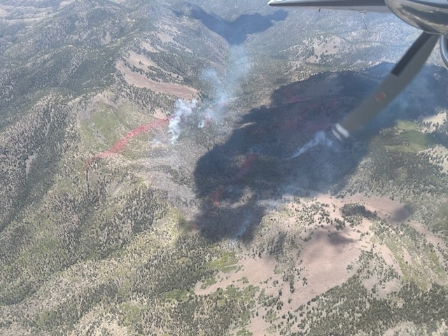
Operations: Minimal fire growth yesterday allowed crews to focus on direct suppression efforts along the fire’s edge, where multiple hotshot crews worked to secure and extinguish hotspots along the perimeter and will continue those efforts today. A structure protection group remains in place at the Langmuir Observatory and nearby structures, while contingency crews continue preparation work along Water Canyon Road (FR235) and northern trail systems. Although no aerial suppression resources were utilized yesterday, aircraft remain supporting operations by delivering supplies to firefighters in remote areas.
The Albuquerque Zone Type 3 Incident Management Team continues to work closely with the Cibola National Forest & National Grasslands to implement both direct and indirect suppression tactics aimed at minimizing fire growth. A decrease in reported acreage is due to a more accurate infrared mapping flight completed yesterday.
Weather: A shortwave disturbance moving in from the west may bring increased cloud cover, breezy conditions, and isolated afternoon thunderstorms near the fire area. While storm chances remain low, firefighters will prepare for strong and erratic outflow winds and the potential for dry lightning.
Closures: A closure order remains in effect for multiple roads and trails within the fire area. Refer to the attached closure order, map, and the Cibola National Forest website for further details. https://www.fs.usda.gov/r03/cibola/alerts.
Safety: The health and safety of firefighters and the public are always the top priority. Fire equipment and personnel will be operating on area road systems, and the public should remain aware of current and any upcoming area closures associated with suppression activities. Drones pose a serious risk to firefighting. The public is reminded that “If you fly, we can’t!”
Smoke may be visible along Highway 60 as well as from Interstate 25. An interactive smoke map at https://fire.airnow.gov/ allows you to zoom into your area to see live smoke conditions.
Additional Information:
Inciweb: https://inciweb.wildfire.gov/incident-information/nmcif-six-mile-fire
Facebook: https://www.facebook.com/cibolanf
New Mexico Fire Info: https://nmfireinfo.com/
Email: 2026.sixmile@firenet.gov


Comments are closed.