
 May 18, 2026
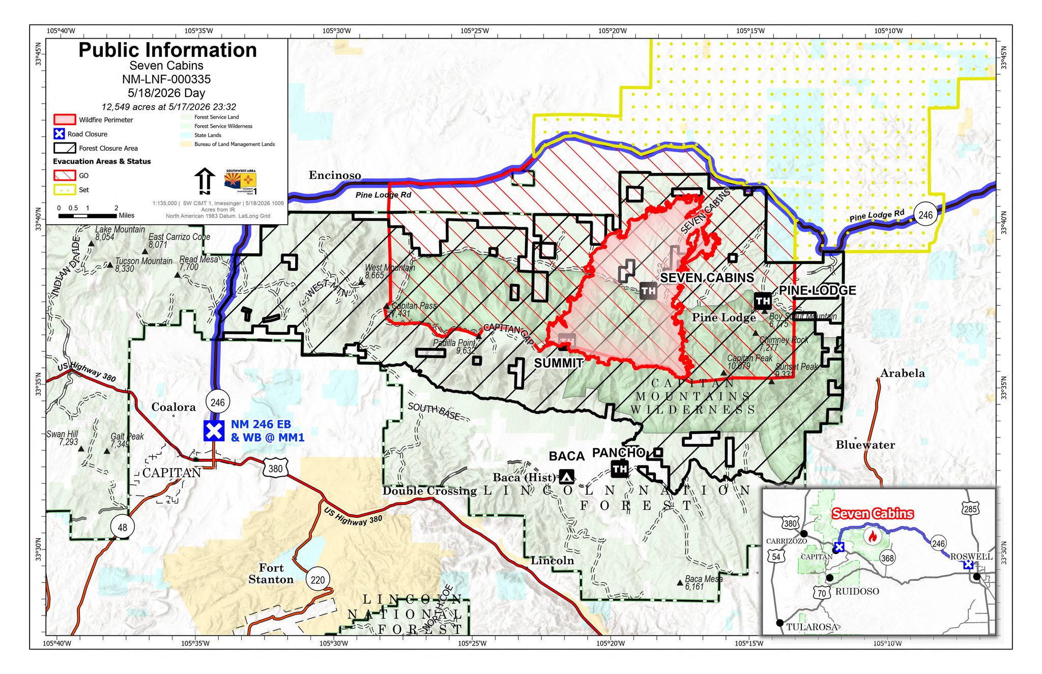
Acres: 12,549 acres Start Date: May 14, 2026
Location: Capitan Mountain Wilderness Cause: Human caused.
Personnel: 613 personnel Fuels: Heavy dead fuels in the
Containment: 0% Contained Peppin burn scar
Resources: 12 crews | 20 engines | 2 helicopters | 11 Water Tenders | 4 dozers
Highlights: Firefighters work to keep the fire south of Highway 246 and west of Arabella.
Operations: Firefighters kept the fire south of Highway 246 yesterday through a day of very high and shifting
winds and dry conditions. Overnight crews continued to improve the control line out of Harrison Canyonand
were able to steer the fire into more favorable terrain. Today, resources will continue working on the control line
out of Harrison Canyon and begin work on the 616 road to construct indirect containment lines where they can
safely slow and hold the fire. Both of these areas have dense fuels and long medical extraction times that make it
unsafe for crews to directly engage with the fire currently. Additional crews have arrived and will be
constructing defensible space around the values at risk within the evacuated areas to prepare those values in case
fire impacts them. With a potential westward shift of the wind, additional resources are working to identify and
improve control lines in the dense fuels between Highway 246 and Arabella. More firefighters arrived late last
night and will continue to arrive to assist with the suppression of this fire. Firefighting aircraft will continue to
provide beneficial support, when weather allows, slowing the spread to allow time for ground resources to
construct control lines. The communications towers located at Summit Peak continue to be unaffected by the fire
and remain fully operational.
Weather: Winds will continue to be high today with expected speeds between 20-30 mph and gusts up to 40
mph.Today winds will shift directions and come out of the west at the lower elevations and the southwest at the
upper elevations. This wind shift will present a concern as it pushes the fire in a new direction into denser fuels.
Warm temperatures and low humidity, between 7 – 11% will continue to drive extreme fire behavior. There is a
Red Flag warning in place and will extend throughout the day.
Smoke: With continued high winds out of the west, residents should expect to continue to see a large smoke
plume that will be visible across much of the state. Residents to the east of the fire may smell and see haze as
smoke drifts into their communities.
Closures: State Highway 246 is closed between mile marker 19 north of Capitan, and Mark Road in Chavez
County. There is a forest closure order in place around the Seven Cabins Fire closing all roads, trails, and access
to the Capitan Mountains wilderness area and surrounding areas. There is a temporary flight restriction (TFR) in
place around the fire to ensure safe access for firefighting aircraft.
Evacuations: There are GO status evacuations currently in place from State Highway 246 to the ridge top of the
Capitan Mountains, between mile marker 13 and Boy Scout Mountain. Residents in this area should leave the
area to ensure their life safety. There is a SET status evacuation north of Highway 246 between mile marker 13
and Boy Scout Mountain.
Safety: Aircraft are still being heavily used to slow fire spread and cannot fly if private drones are in the area.
Remember, if you fly, we can’t. Lincoln county utilizes Genasys Project to coordinate evacuation orders,
residents should sign up at lincolnnm.genasys.com/portal to receive notifications of any updated evacuations.
Phone Number: 505-217-0120 (7a – 7p) Email: 2026.SevenCabins@firenet.gov
Inciweb: https://inciweb.wildfire.gov/incident-information/nmlnf-seven-cabins-fire
Facebook: https://www.facebook.com/SevenCabinsFire/


Comments are closed.