
 June 20, 2026
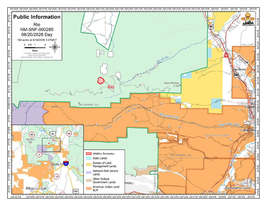
Acres: 184
Start Date: June 16, 2026
Location: Mesa De La Gallina, 3 miles northeast of Chicoma Mountain
Fuels: Oak brush, Ponderosa Pine
Containment: 0% Personnel: 144
Cause: Lightning
Highlights: Firefighters continued to make strong progress Friday, using a full suppression strategy to slow the fire’s spread. No structures have been lost to date. Significant heat remains on the northeastern and southeastern perimeters. A Red Flag Warning is in effect today, and continued hot, dry weather could test fire lines and lead to additional fire growth.
Operations: Utilizing the access point crews cut into the fire on the northern side, firefighters have been hiking in to work directly on the fire’s edge. Many resources, including four Interagency Hotshot Crews (IHCs), are currently assigned to the fire. The Sawtooth IHC is working from the northern access point towards the west, while the Navajo IHC is working east to tie the line into some cliffs. The Santa Fe and Texas Canyon IHCs are accessing the fire from the southern side and are working towards the eastern line to tie them together. Helicopters and fixed-wing aircraft are supporting the firefighters on the ground with water drops to cool the fire’s edge.
Heavy equipment is improving road access on Forest Service Road 31 north of the fire. Once that work is complete, they will begin work on Forest Service Roads 413 and 144. Improved roads help crews access the fire and create a safer environment by decreasing medical evacuation times.
All flanks will continue to be monitored for spots, with emphasis on rocky terrain and dead/down fuels. A contingent of medical personnel, including Rapid Extraction Modules and ambulances are on hand to support and evacuate firefighters in the event of an injury.
Safety: The primary objective for the Rio Fire is firefighter and public safety. A Temporary Flight Restriction (TFR) is in place in the area to keep the area clear for responding aircraft. No drones or aircraft are allowed to fly in the area. Flying will force air resources to be grounded immediately. If you fly, they can’t.
Weather: A Red Flag warning is forecast from noon to 7 p.m. with hot and dry conditions and receptive fuels. Outflow winds from isolated thunderstorms in the region could impact the fire area today. Light winds are likely to remain overnight after all outflow winds have subsided. Deep atmospheric mixing may allow for tall, active smoke plumes and active fire behavior.
Smoke: Smoke monitors have been ordered and are expected to arrive this weekend. Smoke is visible from Taos, Espanola, Abiquiu, Santa Fe, and Los Alamos County. View an interactive smoke map at https://fire.airnow.gov/. Learn more about smoke impacts at https://nmtracking.org/environment/air/FireAndSmoke.html.
Closures: No closures at this time but people are asked to avoid the area and exercise extreme caution as firefighting operations are ongoing.
Fire Information: 505-273-7205 / facebook.com/santafeNF/ https://x.com/SantafeNF/ 2026.rio@firenet.gov/ nmfireinfo.com


Comments are closed.