
 June 21, 2026
Northern New Mexico Type 3 Team
Luke McLarty – Incident Commander
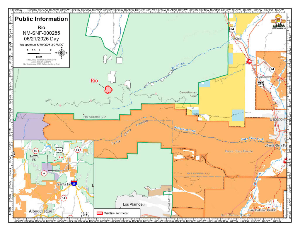
Acres: 184
Start Date: June 16, 2026
Location: Mesa De La Gallina, 3 miles northeast of Chicoma Mountain
Fuels: Oak brush, Ponderosa Pine
Containment: 0% Personnel: 167
Cause: Lightning
Highlights: The four Interagency Hotshot Crews (IHCs) assigned to the fire made further progress on Saturday with support from aviation resources. Hot, dry, and windy conditions caused several areas near the retardant lines to flare up. Aircraft dropped water along those lines to reinforce their effectiveness, allowing firefighters to re-engage and suppress the flare-ups, keeping the fire within its current perimeter.
Operations: On Saturday, the Navajo IHC completed line construction east to rock cliffs, a natural holding feature, and was able to assign several crew members to assist the Sawtooth IHC on the west side of the fire. The Texas Canyon and Santa Fe IHCs worked across the south flank and spiked out overnight, reducing travel time and allowing them to re-engage more quickly this morning. Despite the extremely steep, rugged terrain and hot weather, firefighters are expected to complete and connect handlines around the entire fire today. Once that work is finished, crews will begin identifying hot spots and cooling the fire’s edge to strengthen and secure the lines. Multiple engine crews are also working to secure the firelines and improve road access.
Heavy equipment will continue improving access along Forest Service Road 31 north of the fire before moving to Forest Service Roads 413 and 144. Improved road access allows crews to reach the fire more efficiently and enhances firefighter safety by reducing medical evacuation times.
Archeologists are currently working with firefighting personnel to ensure minimal disturbance to sensitive cultural and heritage sights. Multiple engines remain available to respond to any new fire starts within the Temporary Flight Restriction (TFR) area.
Safety: The primary objective for the Rio Fire is firefighter and public safety. A Temporary Flight Restriction (TFR) is in place in the area to keep the area clear for responding aircraft. No drones or aircraft are allowed to fly in the area. Flying will force air resources to be grounded immediately. If you fly, they can’t.
Weather: Another hot, dry, sunny day is expected with zero chance of precipitation in the forecast. West winds will continue through the afternoon and early evening before diminishing. A very dry airmass will continue pushing in from the west overnight, resulting in low overnight humidity recoveries.
Smoke: Additional smoke monitors have arrived and will be installed over the next few days. Smoke is visible from Taos, Espanola, Abiquiu, Santa Fe, and Los Alamos County. View an interactive smoke map at https://fire.airnow.gov/. Learn more about smoke impacts at https://nmtracking.org/environment/air/FireAndSmoke.html.
Closures: No closures currently but people are asked to avoid the area and exercise extreme caution as firefighting operations are ongoing.
Fire Information: 505-273-7205 / facebook.com/santafeNF/ https://x.com/SantafeNF/ 2026.rio@firenet.gov/ nmfireinfo.com


Comments are closed.