
Trout Fire management being transferred to larger team as evacuations and closures remain in place Acres: 3,910 Start Date: Thursday, June 12, 2025 Location: 12 miles north of Silver City, NM Personnel: 282 Containment: 0% Cause: Under investigation Summary: The Trout Fire north of Silver City continued active growth to 3,910 acres today under hot, […]
Continue readingUpdate: Buck Fire southeast of Aragon, NM
 June 13, 2025
  0 Comments
Acreage: The Buck Fire is now 23,000 acres due to terrain and wind driven runs. The fire has spread to the north over Pelona Mountain. Aerial resources continued to drop water on all active flanks of the fire today to slow spread while firefighters continued securing the southwestern edge. Values at Risk: No additional structures […]
Continue readingGila National Forest issues area closure for Trout Fire
June 13, 2025 0 Comments
Grant County issues evacuation order on west end of New Mexico Highway 35 Silver City, NM, June 13, 2025—Gila National Forest has issued a public safety closure order for Gila National Forest lands and recreation sites threatened by the Trout Fire. The closure area is south and west of New Mexico Highway 35, north of […]
Continue reading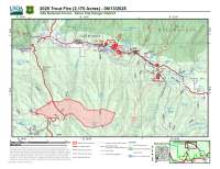
Trout Fire update June 13, 2025
June 13, 2025 0 Comments
Trout Fire prompts highway closure, advisory to leave developed recreation sites Acres: 2,170 Start Date: Thursday, June 12, 2025Location: 12 miles north of Silver City, NM Personnel: 144Containment: 0% Cause: Under investigation Summary: The Trout Fire north of Silver City continued active growth to 2,170 acres yesterday evening under hot, dry, windy conditions, with running, […]
Continue readingUpdate: Buck Fire southeast of Aragon, NM
June 13, 2025 0 Comments
Acreage: 16,000 acres Evacuations are in place for Garcia Camp. Resources: Type 3 team has been ordered. Closure: Continental Divide Trail south of Highway 12 in Catron County is impacted by the Buck Fire. Hikers should avoid this segment of the trail.
Continue readingUpdate: Buck Fire southeast of Aragon, NM
June 12, 2025 0 Comments
Acreage: 14,000 acres, 0% containment No evacuations ordered Additional resources have been ordered
Continue readingUpdate: Buck Fire southeast of Aragon, NM
June 12, 2025 0 Comments
Acreage: estimated at 1,000-1,200 acres The Buck Fire has burned under the electric transmission lines but has since moved away from the lines. The transmission lines stay operational. The fire has moved onto private land and the BLM is currently working with surrounding land owners regarding the fire. No evacuations have been ordered. Updates will […]
Continue readingTrout Fire evening update June 12
June 12, 2025 0 Comments
New Mexico Highway 15 closed to public traffic Silver City, NM, June 12, 2025—The Trout Fire grew eastward today, crossing over New Mexico Highway 15 and resulting in closure of the highway to public traffic from the Highway 15/35 intersection south to the Ben Lilly Memorial. The Gila Las Cruces Type 3 Incident Command Team […]
Continue readingFirefighters respond to new fires on Gila National Forest
June 12, 2025 0 Comments
Meadow and Trout fires are 15 miles north of Silver City Silver City, NM, June 12, 2025—Firefighters are responding to two new wildfires approximately 15 miles north of Silver City. The fires are located east and west of New Mexico Highway 15, in the Meadow Creek and Sheep Corral areas. The Meadow Fire was reported […]
Continue readingBuck Fire – Fire start southeast of Aragon, NM
June 12, 2025 0 Comments
New Fire Start Location: South of Pelona Mountain, Southwest of Magdalena and Datil and Southeast of Aragon. 33°35’44.0″N 108°12’39.0″W Reported start date / time: June 11, 2025 at 2004 Size: 550 acres Cause: Lightning Vegetation: Grass and timber Fire Behavior: The Buck Fire is exhibiting moderate to high fire behavior associated with winds produced by passing thunderstorms. Resources: Multiple resources […]
Continue readingFinal Update: Patterson Fire
June 10, 2025 0 Comments
The Patterson Fire received light rain last night and fire crews were able to get line around the fire perimeter. Size of the fire is updated to 1/2 acre due to mapping. One engine a fire module (small crew) will stay on scene today to secure the perimeter and mop up. This will be the […]
Continue readingPatterson Fire – Fire start east of Aragon, NM
June 9, 2025 0 Comments
New Fire Start Location: South of Highway 12 in-between the town of Aragon to the west and Old Horse Springs to the east. Reported start date / time: June 9, 2025 at 1500 Size: 2 acres Cause: Lightning strike. Vegetation: Ponderosa, grass and brush. Fire Behavior: The Patterson Fire is exhibiting moderate to high fire behavior associated with winds […]
Continue readingSave the Date: NM Wildland Urban Fire Summit 2025, Valencia County
June 4, 2025 0 Comments
Save the date! This year, the NM Wildland Urban Fire Summit will be held Sept. 30-Oct. 2, 2025 in Valencia County. The theme is “Wildfire Futures: Building Community Connections and Empowerment.” Stayed tuned for more information!
Continue readingParadise Fire Update for Monday, June 2, 2025
June 2, 2025 0 Comments
District To Take Over Management Tomorrow Acres: 727 Start Date: Monday, May 26, 2025 Location: 13 miles south of Quemado, NM Personnel: 115 Containment: 92% Cause: Human-caused, under investigation Summary: The Paradise Fire north of Quemado Lake is now 92% contained at 727 acres. Yesterday, the Burned Area Emergency Response team began assessing the impacts […]
Continue reading
Paradise Fire for June 1, 2025
June 1, 2025 0 Comments
Now at 87% Containment Acres: 727 Start Date: Monday, May 26, 2025 Location: 13 miles south of Quemado, NM Personnel: 125 Containment: 87% Cause: Human-caused, under investigation Summary: The Paradise Fire north of Quemado Lake is holding at 727 acres and is now 87% contained. Firefighters have completed dozer line repair work and chipping and […]
Continue reading
Paradise Fire Update for May 31
May 31, 2025 0 Comments
Now 74% Contained Acres: 727 Start Date: Monday, May 26, 2025 Location: 13 miles south of Quemado, NM Personnel: 127 Containment: 74% Cause: Human-caused, under investigation Summary: The Paradise Fire is now 74% contained. This morning, Incident Commander Marcus Cornwell transferred command of the Gila Las Cruces Type 3 Incident Management Team to Dustin Roper. […]
Continue reading
Paradise Fire update for May 30
May 30, 2025 0 Comments
Now 30% Contained Acres: 727 Start Date: Monday, May 26, 2025 Location: 13 miles south of Quemado, NM Personnel: 147 Containment: 30% Cause: Human-caused, under investigation Summary: The Paradise Fire is holding at 727 acres, and crews have increased containment to 30%. Firefighters are working to hold and secure fire lines, while mopping up areas […]
Continue readingCamp Fire Update 5/29/25: Command of the Camp Fire Transitions Back to BLM
May 29, 2025 0 Comments
This will be the last fire update for the Camp Fire unless there is a significant change. Acres: 877 Cause: Under investigation Containment: 76% Total personnel: 69 Structures Damaged: 5Start Date: May 25, 2025 Location: Fort Stanton – Snowy River Cave National Conservation Area Fire Update Command of the Camp Fire, which started on Sunday, […]
Continue readingParadise Fire Update for May 29, 2025
May 29, 2025 0 Comments
Gila Las Cruces Type 3 Incident Management Team Achieves 12% Containment on Paradise Fire Acres: 727 Start Date: Monday, May 26, 2025Location: 13 miles south of Quemado, NM Personnel: 146Containment: 12% Cause: Human-caused, under investigation Summary: Crews worked to bring the Paradise Fire to 12% containment on Wednesday under command of the Gila Las Cruces […]
Continue readingCamp Fire Update 5/28/25: Rob Jaggers Campground and Fort Stanton Reopen Tomorrow
May 28, 2025 0 Comments
Acres: 877 Cause: Under investigation Containment: 70% Total personnel: 120 Structures Damaged: 4Start Date: May 25, 2025 Location: Fort Stanton – Snowy River Cave National Conservation Area Fire Update Containment continues to increase as crews make progress on securing the fire line. The fire has not spread for several days however, after more accurate GIS […]
Continue reading


