
Gila Las Cruces Type 3 Incident Management Team assumes command Acres: 578 Start Date: Monday, May 26, 2025Location: 13 miles south of Quemado, NM Personnel: 115Containment: 0%Cause: Human-caused, under investigation Summary: The Gila Las Cruces Type 3 Incident Management Team assumed command of the Paradise Fire yesterday evening. The Paradise Fire is burning in ponderosa […]
Continue readingCrews Respond to the Middle Fork Fire Near Vallecitos
 May 27, 2025
  0 Comments
Carson National Forest fire crews are on scene of a wildfire west of Vallecitos, N.M., in Rio Arriba County. It’s called the Middle Fork Fire, named after the drainage of the Cañada del Agua near Forest Roads 44 and 106. Estimated at 4 to 5 acres, it’s smoldering and creeping in ponderosa pine. No containment […]
Continue reading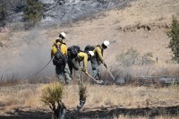
Camp Fire Evening Update 5/27/25: Containment Jumps to 47% on the Camp Fire
May 27, 2025 0 Comments
Acres 720 Cause: Under investigation Containment: 47% Total personnel: 147 Structures Damaged: 4 Start Date: Sunday, May 25, 2025Location: Fort Stanton – Snowy River Cave National Conservation Area Fire Update Crews made significant progress today securing large portions of the fire line on the north and south sides of the fire. Fire containment increased to […]
Continue readingCamp Fire Morning Update 05/27/25: Crews Secure Fire Lines on the Camp Fire
May 27, 2025 0 Comments
Acres: 720 Cause: Under investigation Containment: 4%Total personnel: 147 Structures Damaged: 4Start Date: May 25, 2025 Location: Black Jack Pershing Rd. and Bonito Loop, Fort Stanton, NM Fuels: Pinon-juniper, grass Fire Update Fire lines continue to hold. There was no fire spread overnight. Today fire crews will continue to secure the perimeter of the fire […]
Continue readingControlled Burn in Mora County, Circle E Ranch of Colorado LLC
May 27, 2025 0 Comments
Tuesday, May 27, 2025 Notification of a controlled burn in Mora County by Circle E Ranch of Colorado LLC. Mora County is aware and has approved this controlled burn. Latitude: 36.13418 Longitude 105.30702
Continue reading
Camp Fire Update 5/26/25: Work Continues on the Camp Fire Near Fort Stanton
May 26, 2025 0 Comments
Acres: 720 Cause: Under investigation Containment: 4% Total personnel: 96 Structures Damaged: 4Start Date: May 25, 2025Location: Black Jack Pershing Rd. and Bonito Loop, Fort Stanton, NMFuels: Pinon-juniper, grass Fire Update Crews were able to better map the fire perimeter today and the new total acreage is 720. Most of the burned acres occurred yesterday […]
Continue readingCamp Fire Update 5/26/25: Progress Made on the Camp Fire
May 26, 2025 0 Comments
Acres: 350 Cause: Under investigation Containment: 0% but will likely increase as the day progresses Total personnel for all incidents: 78Start Date: May 25, 2025 Location: Black Jack Pershing Rd. and Bonito Loop, Fort Stanton, NM Fuels: Pinon-juniper, grass Fire Update: Yesterday firefighters and air support responded to the Camp Fire in the Ft. Stanton […]
Continue readingMerrill Fire – Final Update
May 25, 2025 0 Comments
Zuni Mountains, New Mexico Albuquerque, NM – May 25, 2025: On May 23rd multiple resources responded to a fire start on private lands south of NM I-40, West of Grants, NM since named the Merrill Fire. The origin of the fire was on private lands crossing into adjacent Forest Service lands of the Mt Taylor […]
Continue readingFirefighters on Scene of Merrill Fire
May 24, 2025 0 Comments
Zuni Mountains, New Mexico Albuquerque, NM – May 24, 2025: Yesterday evening, multiple resources responded to a fire start on private lands south of NM I-40, West of Grants, NM since named the Merrill Fire. The origin of the fire was on private lands crossing into adjacent Forest Service lands of the Mt Taylor Ranger […]
Continue readingBLM Albuquerque and Las Cruces Districts implement fire restrictions
May 23, 2025 0 Comments
The Bureau of Land Management (BLM) will implement fire restrictions on May 23, 2025, to reduce the risk of wildfire on public lands in the Albuquerque and Las Cruces Districts. This includes public lands in Bernalillo, Catron, Cibola, Doña Ana, Hidalgo, Grant, Luna, McKinley, Otero, Sandoval, Sierra, Socorro, Torrance, and Valencia counties. Prohibited acts include: […]
Continue readingControlled Burn, Circle E Ranch of Colorado LLC
May 20, 2025 0 Comments
Tuesday, May 20, 2025 Notification of a controlled burn in Mora County by Circle E Ranch of Colorado LLC. Mora County is aware and has approved this controlled burn. Latitude: 36.13418 Longitude 105.30702
Continue readingMagdalena Ranger District to Implement Stage 1 Fire Restrictions
May 19, 2025 0 Comments
ALBUQUERQUE, NM – May 19, 2025 – The Cibola National Forest and National Grasslands will implement Stage 1 Fire Restrictions on all National Forest System (NFS) lands in the Magdalena Ranger District as described per order 03-03-03-25-08 and as shown on the attached map. This Order shall be in effect from Thursday May 22, 2025 […]
Continue readingMountainair and Sandia Ranger Districts to Implement Stage 2 Fire Restrictions
May 19, 2025 0 Comments
ALBUQUERQUE, NM – May 19, 2025 The Cibola National Forest and National Grasslands will implement Stage 2 Fire Restrictions on the Mountainair and Sandia Ranger Districts located within the State of New Mexico as described per order 03-03-00-25-07 and as shown on the attached maps. This Order will be in effect on May 22, 2025, […]
Continue readingLocal resources are responding to Outlaw, Gallinas, and Carrizo Fires
May 17, 2025 0 Comments
Local firefighting resources are responding to three wildland fires in the Grant County area, including the Carrizo, Outlaw, and Gallinas fires. The string of fires were started by lightning strikes early this morning. They are located east of San Lorenzo and south of New Mexico Highway 152. The Carrizo Fire is 20-acres, burning in grass, […]
Continue readingIron Fire Press Release – Tuesday, May 13, 2025
May 13, 2025 0 Comments
Wind Event Moves in as Team Prepares to Transfer Command to the Gila National Forest Acres: 482 Start Date: Sunday, May 4, 2025Location: 38 miles east of Glenwood, NM Personnel: 142Containment: 100% Cause: Lightning Summary: This will be the FINAL press release for the Iron Fire. The fire is 100% contained as of Monday afternoon. No […]
Continue readingCinder Cone Fire – Final Update 5/12/2025 PM Update
May 12, 2025 0 Comments
Cinder Cone Fire on Mt. Taylor Ranger District: Final Update Reported start date / time: May 11, 2025, 9:30am Cause: Unknown Size: 7.2 acres Location: Mt. Taylor Ranger District – Zuni Mountains near Quartz Hill Resources: Mt. Taylor Ranger District, Cibola County Emergency Services, Milan VFD, El Moro VFD Strategy: Full suppression Evacuations: NO Evacuations […]
Continue readingIron Fire Press Release – Sunday, May 11, 2025
May 12, 2025 0 Comments
Helicopters Support Final Operations as Resources Exit Fireline Safely Acres: 482 Start Date: Sunday, May 4, 2025 Location: 38 miles east of Glenwood, NM Personnel: 173 Containment: 92% Cause: Lightning Summary: Mop-up operations continue across the fire area, with crews now working to a depth of up to 100 feet where conditions allow. This effort […]
Continue readingIron Fire Press Release – Saturday, May 10, 2025
May 12, 2025 0 Comments
Ground Mapping Completed as Containment Increases Acres: 482 Start Date: Sunday, May 4, 2025 Location: 38 miles east of Glenwood, NM Personnel: 200 Containment: 77% Cause: Lightning Summary: Ground-based GPS mapping of the Iron Fire has been completed, providing a highly accurate and detailed representation of the final fire perimeter. The fire has been mapped […]
Continue readingIron Fire Press Release – Friday, May 9, 2025
May 12, 2025 0 Comments
Firefighters Begin Ground Mapping; Snow Lake Reopens for Public Use Acres: 637 Start Date: Sunday, May 4, 2025 Location: 38 miles east of Glenwood, NM Personnel: 183 Containment: 45% Cause: Lightning Summary: Firefighters initiated a ground-based GPS perimeter walk yesterday to improve the accuracy of fire mapping. While the effort is still underway, the northern […]
Continue readingNew Start on Mt. Taylor Ranger District: Cinder Cone Fire Update
May 11, 2025 0 Comments
Reported start date / time: May 11, 2025, 9:30am Cause: Unknown Size: 7.2 acres Location: Mt. Taylor Ranger District – Zuni Mountains near Quartz Hill Resources: Mt. Taylor Ranger District, Cibola County Emergency Services, Milan VFD, El Moro VFD Strategy: Full suppression Evacuations: NO Evacuations are currently in effect Values at risk: Paxton Springs Subdivision, […]
Continue reading


