
ROSWELL, N.M. – In March, the Bureau of Land Management plans to conduct a prescribed burn operation about 33 miles northwest of Roswell in Chaves County. The operation will take place within an area of 587 acres but will only burn about 25% of the land within that area. The operation is weather dependent and […]
Continue reading
Archive | Prescribed Burns RSS feed for this section
BLM plans prescribed burn activities in Eddy County
 February 21, 2026
  0 Comments
CARLSBAD, N.M. – Beginning in February, the Bureau of Land Management plans to conduct prescribed burn operations in Eddy County. Specifically, the BLM plans operations at the Black River Recreation Area on 105 acres; at Cottonwood Springs south of Carlsbad on 350 acres; and at Hay Hollow on 105 acres. The operations, which may continue […]
Continue readingBLM plans prescribed burn activities in Lincoln County
February 17, 2026 0 Comments
ROSWELL, N.M. – Beginning in February, the Bureau of Land Management plans to conduct prescribed burn operations in Lincoln County. Specifically, the BLM plans operations at the Fort Stanton – Snowy River Cave National Conservation Area on 2,026 acres within four burn units. The operations, which will continue through March, are weather dependent and will take […]
Continue readingBLM plans prescribed burn activities in Chaves County
February 17, 2026 0 Comments
ROSWELL, N.M. – Beginning in February, the Bureau of Land Management plans to conduct prescribed fire operations in Chaves County. Specifically, the operations are planned to take place on 5,343 acres in the Lesser Prairie-Chicken Habitat Preservation Area of Critical Environmental Concern, near U.S. Route 380 east of Roswell. Many refer to the area as the […]
Continue readingGila National Forest to begin prescribed burns near Mimbres
January 5, 2026 0 Comments
MIMBRES, N.M., Jan. 5 – Due to favorable weather conditions with increased precipitation forecasted this week, the Wilderness Ranger District on the Gila National Forest plans to implement prescribed fire operations on Wednesday and Thursday of this week, Jan. 7 and 8, pending all required approvals. We estimate this work to continue through the month […]
Continue readingPrescription Burns in Quemado RD (Gila National Forest) postponed until further notice
December 15, 2025 0 Comments
The Quemado Ranger District on the Gila National Forest is planning to start prescribed fire operations this winter, continuing through the winter as weather conditions allow and pending all required approvals. We use prescribed fires to help reduce overgrown vegetation to help protect local communities, infrastructure and natural resources from wildfires. Prescribed fires planned for […]
Continue reading Gila National Forest to begin prescribed fires near Mimbres
December 9, 2025 0 Comments
The Wilderness Ranger District on the Gila National Forest is planning prescribed fire operations beginning Dec. 14 and continuing through the month of December, pending all required approvals and as weather conditions allow. We use prescribed fires to help reduce overgrown vegetation to help protect local communities, infrastructure and natural resources from wildfires. Prescribed fires […]
Continue readingBLM plans prescribed fire activities in Lincoln County
July 31, 2025 0 Comments
Public Input & Action BLM Roswell Field Office Media Contact: Wendy Brown, 575-627-0259, wabrown@blm.gov July 31, 2025 ROSWELL, N.M. – Beginning in August, the Bureau of Land Management plans to conduct prescribed fire operations in Lincoln County at the Fort Stanton – Snowy River Cave National Conservation Area. The operations may continue through late September, […]
Continue readingControlled Burn, Circle E Ranch of Colorado LLC
May 20, 2025 0 Comments
Tuesday, May 20, 2025 Notification of a controlled burn in Mora County by Circle E Ranch of Colorado LLC. Mora County is aware and has approved this controlled burn. Latitude: 36.13418 Longitude 105.30702
Continue readingNational Park Service Planning Second Prescribed Fire at El Malpais National Monument
May 10, 2024 Comments Off on National Park Service Planning Second Prescribed Fire at El Malpais National Monument
National Park Service Planning Second Prescribed Fire at El Malpais National Monument May 10, 2024 Contact: El Malpais Visitor Center, 505.876.2783, Lafe Sackett, 505.783.4290 Grants, NM – The National Park Service is preparing to conduct a prescribed fire on the north side of El Malpais National Monument which is tentatively scheduled to occur in late […]
Continue readingValles Caldera National Preserve Begins Prescribed Burns on San Antonio Mountain
January 14, 2024 0 Comments
Valles Caldera National Preserve News Release Release Date: January 12, 2024 Contact: Dave Krueger, Chief of Interpretation (vall_news@nps.gov) Jemez Springs, NM – With good snow conditions, National Park Service fire managers plan to start burning piles on 225 acres in the San Antonio Mountain Pile Unit of Valles Caldera National Preserve as early as Tuesday, January 16. […]
Continue readingValles Caldera Plans 2023-24 Winter Prescribed Burns
December 1, 2023 0 Comments
Valles Caldera National Preserve News Release Release Date: November 30, 2023 Contact: Dave Krueger, Chief of Interpretation (vall_news@nps.gov) Valles Caldera Plans 2023-24 Winter Prescribed Burns Jemez Springs, NM – The National Park Service plans to implement prescribed burn projects in Valles Caldera National Preserve beginning December 2023 through the end of the 2023-24 winter season as […]
Continue readingBLM plans prescribed burn activities in Chaves County
September 25, 2023 0 Comments
The Pecos District Fire Program plans to burn piles of slashed Juniper trees nine-miles south of Dunken, N.M. This project consists of burning 20 acres of piles created during a tree removal project and should take one day to complete, weather permitting. The burn will begin Sept. 26. Once ignitions are complete, crews will remain […]
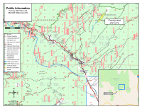
Continue readingWilderness Ranger District continues prescribed burning this week – Projects along New Mexico Highway 35 will reduce hazardous fuels near private lands
May 5, 2023 0 Comments
May 3, 2023 – The Gila National Forest, Wilderness Ranger District continues burning this week on the 165-acre Heifer Prescribed Fire project – located adjacent to Gattons Park, and the 1000-acre Gravel Prescribed Fire unit located off the Lincoln Canyon Road (USFS Road 4079-T). The project areas will be signed and posted for public awareness during prescribed fire activities.
Continue readingBLM Rio Puerco Field Office to implement three prescribed fires
December 8, 2022 0 Comments
Throughout the winter season, the Bureau of Land Management (BLM) will implement three prescribed fires, depending on weather conditions. The Mesa Chivato Prescribed Fire will be within the Ignacio Chavez and Chamisa Wilderness Study Areas, west of Highway 550 and 15 miles southwest of San Luis, in Sandoval and McKinley counties. The project is part of a […]
Continue readingPrescribed Fire Planned on State Trust Land – South of Pie Town, NM
November 10, 2022 0 Comments
The New Mexico State Land Office (NMSLO) is planning a collaborative prescribed fire scheduled for Nov. 11-17, 2022, on approximately 400 acres of state trust land near Mangas Divide (approximately 16 miles southwest of Pie Town, NM in Catron County). The project is being implemented in the fall while there is an opportunity to safely and responsibly meet burn objectives and […]
Continue readingBLM plans prescribed fire in Catron County, Nov.-Dec. 2022
October 21, 2022 0 Comments
Beginning November 1 and ending December 31, the Bureau of Land Management (BLM) Socorro Field Office plans to burn piles of juniper and piñon cuttings in three locations in Catron County, weather permitting. Details on each location and size are as follows: Active ignition will take one to five days, with some smoke visible in the […]
Continue readingPartners to Conduct Fall Season Prescribed Fire at Cottonwood Gulch’s Basecamp
September 20, 2022 0 Comments
Cottonwood Gulch Expeditions, Forest Stewards Guild, The Ember Alliance, The Nature Conservancy, and collaborative partners to implement a broadcast burn at Cottonwood Gulch’s Basecamp this fall season. Santa Fe, NM – Cottonwood Gulch Expeditions is partnering with the Forest Stewards Guild (the Guild), The Ember Alliance, The Nature Conservancy, McKinley County, and a diverse group […]
Continue readingBLM plans prescribed burn activities in Chaves and Lincoln counties
March 24, 2022 0 Comments
The Bureau of Land Management (BLM) will conduct prescribed fire operations beginning this week and lasting through May. The agency plans to burn approximately 1,400 acres throughout Chaves and eastern Lincoln counties. The operations are weather dependent and will take several days to complete. Smoke from the burn may be visible from Roswell, Midway, Dexter, […]
Continue reading


