
CARLSBAD, N.M. – Due to high fire danger, the Bureau of Land Management is implementing fire restrictions on public land at the Black River Management Area in Eddy County. The restrictions go into effect at 8 a.m. April 1 and will remain in effect until further notice. Prohibited acts include: Also note that Fire Prevention […]
Continue reading
Archive | Southern New Mexico RSS feed for this section


BLM implements fire restrictions at Fort Stanton-Snowy River Cave NCA and Lincoln Tracts
 March 24, 2026
  0 Comments
ROSWELL, N.M. – Due to high fire danger, the Bureau of Land Management is implementing fire restrictions on public land at the Fort Stanton – Snowy River Cave National Conservation Area and the BLM-Rio Bonito Acquired Lands in Lincoln County. The restrictions go into effect at 8 a.m. March 25 and will remain in effect […]
Continue readingBLM Pecos District plans prescribed burn northwest of Roswell
March 4, 2026 0 Comments
ROSWELL, N.M. – In March, the Bureau of Land Management plans to conduct a prescribed burn operation about 33 miles northwest of Roswell in Chaves County. The operation will take place within an area of 587 acres but will only burn about 25% of the land within that area. The operation is weather dependent and […]
Continue readingBLM plans prescribed burn activities in Eddy County
February 21, 2026 0 Comments
CARLSBAD, N.M. – Beginning in February, the Bureau of Land Management plans to conduct prescribed burn operations in Eddy County. Specifically, the BLM plans operations at the Black River Recreation Area on 105 acres; at Cottonwood Springs south of Carlsbad on 350 acres; and at Hay Hollow on 105 acres. The operations, which may continue […]
Continue readingBLM plans prescribed burn activities in Lincoln County
February 17, 2026 0 Comments
ROSWELL, N.M. – Beginning in February, the Bureau of Land Management plans to conduct prescribed burn operations in Lincoln County. Specifically, the BLM plans operations at the Fort Stanton – Snowy River Cave National Conservation Area on 2,026 acres within four burn units. The operations, which will continue through March, are weather dependent and will take […]
Continue readingBLM plans prescribed burn activities in Chaves County
February 17, 2026 0 Comments
ROSWELL, N.M. – Beginning in February, the Bureau of Land Management plans to conduct prescribed fire operations in Chaves County. Specifically, the operations are planned to take place on 5,343 acres in the Lesser Prairie-Chicken Habitat Preservation Area of Critical Environmental Concern, near U.S. Route 380 east of Roswell. Many refer to the area as the […]
Continue readingBLM plans prescribed fire activities in Lincoln County
July 31, 2025 0 Comments
Public Input & Action BLM Roswell Field Office Media Contact: Wendy Brown, 575-627-0259, wabrown@blm.gov July 31, 2025 ROSWELL, N.M. – Beginning in August, the Bureau of Land Management plans to conduct prescribed fire operations in Lincoln County at the Fort Stanton – Snowy River Cave National Conservation Area. The operations may continue through late September, […]
Continue reading BLM implements fire restrictions at Fort Stanton – Snowy River NCA and Lincoln Tracts
March 10, 2025 0 Comments
Due to high fire danger and prolonged drought, the Bureau of Land Management (BLM) is implementing fire restrictions on public land at the Fort Stanton – Snowy River Cave National Conservation Area and BLM lands around the community of Lincoln. The restrictions go into effect at 8 a.m. March 10 and will remain in effect until further notice.
Continue reading Apple Tree Fire, June 21 Update
July 21, 2023 0 Comments
Start Date / Time: July 18, 2023, 9:00 pm Cause: Lightning Size: 62 acres Containment: 2% Location: East of Sacramento Lookout Tower, 6 mi. north of the community of Timberon, 3.5 miles southeast of Sunspot, NM. Fire Strategy: Confine and contain Resources: 1 type-1 crew, 1 type-2 crew, 1 fuels crew, 1 dozer, 2 engines, 1 module, additional […]
Continue readingPeppin Canyon Fire Update: 6/12/22, 11am
June 12, 2022 0 Comments
Jurisdiction: Lincoln National Forest, Smokey Bear Ranger District Size: 2.5 acres Cause: Lightning Date/Time Detected: June 11, 2022, 3:00 pm Location: North side of the Capitan Wilderness.Map of the fire’s location: https://maps.nwcg.gov/sa/#/%3F/%3F/33.5984/-105.3212/12 Firefighting Resources: 1 wildland fire module, 1 engine, 1 repel crew, 2 helicopters. Fuel Type: The fire is in a burn scar and is consuming […]
Continue reading Black Fire Daily Update: 5/27/22
May 27, 2022 0 Comments
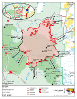
Firefighters working day and night to contain the Black FireCritical fire weather anticipated through the weekend Acres: 191,459 acres Location: 31 miles NW of Truth or Consequences Containment: 13% Personnel: 784 Start Date: Friday, May 13, 2022 Cause: Human-caused, under investigation Fuels: Timber and tall grass Structures Lost: 2 Overview: The Black Fire has over […]
Continue reading Prescribed Burns Scheduled on the Lincoln National Forest, Smokey Bear Ranger District
February 7, 2022 0 Comments
Prescribed Burns West of Ruidoso Ruidoso, NM – Feb. 7, 2022—The Smokey Bear Ranger District on the Lincoln National Forest is planning to conduct prescribed burns in the Grindstone and Perk Canyon areas west of Ruidoso as early as tomorrow, Tuesday, February 8. Prescribed burning will continue throughout winter and spring as conditions allow. Crews […]
Continue readingBLM NM Transfers Fire Engine to White Oaks Fire District
February 3, 2022 0 Comments
On January 20, BLM New Mexico transferred a fire engine to White Oaks Fire District (FD), located in Lincoln County, New Mexico, through the BLM’s Rural Fire Readiness (RFR) program. The transfer took place at the Lincoln County Office of Emergency Services in Ruidoso. The White Oaks FD and Lincoln County have a strong working […]
Continue reading Prescribe Burn Scheduled on the Lincoln National Forest, Sacramento Ranger District
January 19, 2022 0 Comments
Pile Burning in La Laz and Maruche Canyons ALAMOGORDO, NM – Jan. 19, 2022 —Fire managers on the Lincoln National Forest are planning to prescribe burn piles of slash in La Laz and Maruche Canyons, 2—3 miles north of High Rolls, beginning this week in advance of warmer, drier weather come summer. Approximately 146 acres […]
Continue readingNew Fire Start: Cora Dutton Fire, Lincoln National Forest, Smokey Bear Ranger District
December 30, 2021 0 Comments
Incident Name – Cora Dutton Fire Jurisdiction: Lincoln National Forest, Smokey Bear Ranger District Size: 21 Acres Cause: Human Caused Date/Time Detected: Dec. 30, 2021, 1:50 pm Location: 1/2 mile south of Nogal Lake off of Highway 37. Near Ranchos Camp and Cora Dutton. Firefighting Resources: Forest Service and Lincoln County firefighters are on scene. Fuel Type: […]
Continue readingCathey Vista 4 Fire Update
November 23, 2021 0 Comments
Name: Cathey Vista 4 Fire Location: Near Cathy Vista and Cathey Canyon Trail (T105A) on the Sacramento Ranger District, Lincoln National Forest Size: 0.75 acres Cause: Unknown Update: Firefighters have stopped forward progress of the Cathey Vista 4 Fire, previously called the Cathy Vista Fire. The fire is burning in dead and down woody debris […]
Continue readingGila NF: Hazardous Fuel Reduction Project planned for Poverty Creek Wildland Urban Interface
October 15, 2021 0 Comments
Truth or Consequences, NM. October 15, 2021. The Gila National Forest, Black Range Ranger District is planning a hazardous fuels reduction project, estimated at 150 acres in the Poverty Creek Wildland Urban Interface (WUI). The Black Range Ranger District is continuing work on reducing hazardous fuels, including prescribed burning, for the fall/winter of 2021-2022 on […]
Continue readingThree Rivers Fire Update – May 13, 2021
May 13, 2021 0 Comments
Updates will now be released every other day unless there is a significant change to report. Acres: 7,040 acres Containment: 50% Vegetation: Grass, dead/down timber, and mixed conifer. Start Date: April 26, 2021 Cause: Unknown, Under Investigation Origin Location: ½ mile north of Three Rivers Campground; fire spread towards Ski Apache and the South Fork/Bonito area. Ruidoso, New Mexico, May […]
Continue readingThree Rivers Fire Update – May 11, 2021
May 11, 2021 0 Comments
Updates will now be released every other day unless there is a significant change. Acres: 7,040 acres Containment: 50% Vegetation: Grass, dead/down timber, and mixed conifer. Start Date: April 26, 2021 Cause: Unknown, Under Investigation Origin Location: ½ mile north of Three Rivers Campground; fire spread towards Ski Apache and the South Fork/Bonito area. Ruidoso, New Mexico, May 11, 2021 – On Sunday, May […]
Continue readingThree Rivers Fire Update – May 3, 2021
May 3, 2021 0 Comments
Acres: 7,119 Percent Containment: 23% Date/Time Detected: 8:42 am, April 26, 2021 Resources: 317 Vegetation: Grass, dead/down timber, mixed conifer Cause: Unknown, under investigation Origin/Location: ½ mile north of Three Rivers Ruidoso, New Mexico, March 3, 2021 – Strong wind gusts yesterday tested the fire lines constructed by fire crews over the past several days. […]
Continue reading


