
MIMBRES, N.M., Jan. 5 – Due to favorable weather conditions with increased precipitation forecasted this week, the Wilderness Ranger District on the Gila National Forest plans to implement prescribed fire operations on Wednesday and Thursday of this week, Jan. 7 and 8, pending all required approvals. We estimate this work to continue through the month […]
Continue reading
Archive | Forest Service RSS feed for this section
Prescription Burns in Quemado RD (Gila National Forest) postponed until further notice
 December 15, 2025
  0 Comments
The Quemado Ranger District on the Gila National Forest is planning to start prescribed fire operations this winter, continuing through the winter as weather conditions allow and pending all required approvals. We use prescribed fires to help reduce overgrown vegetation to help protect local communities, infrastructure and natural resources from wildfires. Prescribed fires planned for […]
Continue reading Gila National Forest to begin prescribed fires near Mimbres
December 9, 2025 0 Comments
The Wilderness Ranger District on the Gila National Forest is planning prescribed fire operations beginning Dec. 14 and continuing through the month of December, pending all required approvals and as weather conditions allow. We use prescribed fires to help reduce overgrown vegetation to help protect local communities, infrastructure and natural resources from wildfires. Prescribed fires […]
Continue readingPrepared at Home: Spark Safety Not Wildfire
March 29, 2025 0 Comments
Are you prepared for a power outage during wildfire season? Whether an unexpected outage occurs from a wildfire or is a temporary action by your utility company to prevent wildfires, you may be impacted. Consider that an outage can impact lighting, heating, cooling, communication, food and medicine refrigeration, cooking and medical equipment. The American Red […]
Continue readingOn the Road: Spark Safety Not Wildfire
March 29, 2025 0 Comments
Did you know? Wildfires started by vehicles is one of the highest causes in New Mexico. You can Spark Safety Not Wildfire by:
Continue readingPrepared Worker: Spark Safety Not Wildfire
March 28, 2025 0 Comments
Getting outside for spring projects? Managing a crew? If using equipment, remember these safety tips:
Continue readingPrepared Camper: Spark Safety Not Wildfire
March 27, 2025 0 Comments
Concerned with winds picking up on your trip? Skip the campfire, use a propane fire ring instead! Just like with a campfire, place in cleared area, keep it maintained, and never leave it running unattended! The best part is you can just turn it off. Campfire Safety The prepared camper’s checklist:
Continue readingCampfire Safety: Spark Safety Not Wildfire
March 26, 2025 0 Comments
Campfires and outdoor recreation are the 2nd largest category of wildfires caused by people in the southwest. Buried embers can smolder for days. Always drown, stir, feel for heat, and repeat until cold. #sparksafetynotwildfire
Continue readingBurn Barrel Safety: Spark Safety Not Wildfires
March 25, 2025 0 Comments
Thinking about using a burn barrel? Clear 10 feet to mineral soil around the barrel. Make sure it’s properly ventilated and has a 1/8” screen cover to prevent ember escape. Check for holes that would allow embers to escape and screen those areas also or replace the barrel. Always keep water and tools nearby! Spark […]
Continue readingBurn Debris Safely: Southwest Wildfire Awareness Week
March 24, 2025 0 Comments
Did you know? Debris and open burning are the top cause of human-caused fires in the Southwest. Backyard debris burning video from Smokey Bear and the Ad Council. Stay safe and protect your property while burning debris by following these six tips:
Continue readingJoin Us! SW Wildfire Awareness Week, March 24-29, 2025
March 24, 2025 0 Comments
Today kicks off the Southwest Wildfire Awareness Week. This year’s theme is “Spark Safety Not Wildfires,” focused on the three top causes of wildfires in New Mexico: 1)Debris and Open Burning, 2)Campfires, and 3)Equipment/vehicles. Recognizing that conditions in the West remain warm and dry, residents have an opportunity to take proactive steps. From the desert […]
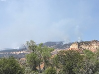
Continue reading Indios Fire Update, May 23, 2024
May 23, 2024 0 Comments
Acres: 851 Start Date: 5/19/2024 Location: 7 miles north of the village of Coyote, N.M. Personnel: 127 Containment: 0% Fuels: Timber, litter, understory Resources: 3 crews | 1 helicopter | 5 engines| 1 road grader | 2 masticators Highlights: The Northern New Mexico Type 3 team, Incident Commander Luke McLarty, assumed command of the […]
Continue readingSpring is a time for action: SW Wildfire Awareness Week is coming
March 12, 2024 0 Comments
With the weather warming, the start of spring winds, and Southwest Wildfire Awareness Week at the end of the month, now is the time for residents of the southwest to take proactive steps against destructive wildfire. From the desert to the bosque to the mountains, individuals and communities shouldn’t feel helpless; they can learn how […]
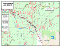
Continue readingWilderness Ranger District continues prescribed burning this week – Projects along New Mexico Highway 35 will reduce hazardous fuels near private lands
May 5, 2023 0 Comments
May 3, 2023 – The Gila National Forest, Wilderness Ranger District continues burning this week on the 165-acre Heifer Prescribed Fire project – located adjacent to Gattons Park, and the 1000-acre Gravel Prescribed Fire unit located off the Lincoln Canyon Road (USFS Road 4079-T). The project areas will be signed and posted for public awareness during prescribed fire activities.
Continue readingPrevent Equipment Ignitions: SW Wildfire Awareness Week
March 28, 2023 0 Comments
At home or work, maintain spark arresters on chainsaws, generators, and other small equipment. One less spark, one less wildfire! (NMfireinfo.com) #PreventWildfires #NMFire #SouthwestWildfireAwarenessWeek
Continue readingPrevent Vehicle Ignitions: SW Wildfire Awareness Week
March 28, 2023 0 Comments
Is your vehicle road-worthy? Prevent wildfires by performing a pre-trip vehicle check. Ensure optimal tire pressure & secure tow chains, so they won’t drag. One Less Spark, One Less Wildfire. Learn more at https://goo.gl/kCkMQH #OneLessSparkNM #SouthwestWildfireAwarenessWeek
Continue reading2022 NM Wildland Urban Fire Summit Registration Now Open!
October 17, 2022 0 Comments
Wildfire Preparedness is Year-Round: Remove Dead Plants and Debris from Property
October 6, 2022 0 Comments
As fall approaches and cooler temperatures set in, wildfire season can seem like a distant concern. However, this is a great time to begin preparations for the next fire season and clean up around your home. The 2022 Wildfire Preparedness is Year-Round campaign provides monthly wildfire preparedness tasks that follow the changing seasons. The October […]
Continue readingWildfire Preparedness is Year-Round: Skip the Fireworks to Support Firefighters
June 30, 2022 0 Comments
Fireworks are a popular Fourth of July tradition. Over the years, many of us have personally experienced close calls and disasters related to firework-ignited fires – a stray ember on a rooftop, burnt grass, smoldering casings and other potential ignition sources. With an early start to the 2022 wildfire season, your NM wildfire cooperators and […]
Continue readingPeppin Canyon Fire Update: 6/12/22, 11am
June 12, 2022 0 Comments
Jurisdiction: Lincoln National Forest, Smokey Bear Ranger District Size: 2.5 acres Cause: Lightning Date/Time Detected: June 11, 2022, 3:00 pm Location: North side of the Capitan Wilderness.Map of the fire’s location: https://maps.nwcg.gov/sa/#/%3F/%3F/33.5984/-105.3212/12 Firefighting Resources: 1 wildland fire module, 1 engine, 1 repel crew, 2 helicopters. Fuel Type: The fire is in a burn scar and is consuming […]
Continue reading


