
Size: 2.5 acres Cause: Lightning Date/Time Detected: June 11, 2022, 3:00 pm Location: North side of the Capitan Wilderness. Map of the fire’s location: https://maps.nwcg.gov/sa/#/%3F/%3F/33.5984/-105.3212/12 Firefighting Resources: 1 wildland fire module, 1 engine, 1 repel crew, 2 helicopters. Fuel Type: The fire is in a burn scar and is consuming brush and dead-and-down and dead-standing […]
Continue reading
Tag Archives: Smokey Bear Ranger District
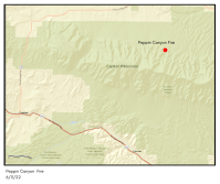


Peppin Canyon Fire Update: 6/12/22, 11am
 June 12, 2022
  0 Comments
Jurisdiction: Lincoln National Forest, Smokey Bear Ranger District Size: 2.5 acres Cause: Lightning Date/Time Detected: June 11, 2022, 3:00 pm Location: North side of the Capitan Wilderness.Map of the fire’s location: https://maps.nwcg.gov/sa/#/%3F/%3F/33.5984/-105.3212/12 Firefighting Resources: 1 wildland fire module, 1 engine, 1 repel crew, 2 helicopters. Fuel Type: The fire is in a burn scar and is consuming […]
Continue reading Peppin Canyon Fire Update: 6/11/22, 8pm
June 11, 2022 0 Comments
Jurisdiction: Lincoln National Forest, Smokey Bear Ranger District Size: 2.5 acres Cause: Lightning Location: North side of the Capitan Wilderness.Map of the fire’s location: https://maps.nwcg.gov/sa/#/%3F/%3F/33.5984/-105.3212/12 Firefighting Resources: 1 wildland fire module, 1 engine, 1 repel crew, 1 type-3 helicopter. 2 single-engine airtankers. Fuel Type: The fire is in a burn scar and is burning in brush and dead and down […]
Continue readingNew Start-Peppin Canyon Fire, Lincoln National Forest
June 11, 2022 0 Comments
Incident Name – Peppin Canyon Fire Jurisdiction: Lincoln National Forest, Smokey Bear Ranger District Size: 2 acres Date/Time Detected: June 11, 2022, 3:00 pm Cause: Lightning Location: North side of the Capitan Wilderness Firefighting Resources: County and Forest Service firefighting resources. Type 3 helicopter. Air Attack. Fuel Type: The fire is in a burn scar and is […]
Continue readingLincoln National Forest in Stage 2 Fire Restrictions
April 28, 2022 0 Comments
The Lincoln National Forest joins other forest and parks in New Mexico who are implementing strict fire restrictions among a flurry of wildfires across the state. The Lincoln National Forest is entering Stage 2 fire restrictions just a week after going into Stage 1 restrictions. Under stage 2 fire restrictions the following is prohibited All […]
Continue readingNogal Canyon Fire Update: April 13, 10am
April 13, 2022 0 Comments
Firefighters Work to Contain Nogal Canyon Fire Location: Nogal Canyon Start date: April 13, 2022 Cause: Downed Powerlines Size: 400 acres Containment: 0% Resources: Lincoln County and US Forest Service Vegetation: Pinon/Juniper/Ponderosa Pine Capitan, NM April 13, 2022, 10:00 am. Yesterday, winds of 45 mph, with gusts from 50-90 mph, were responsible for downed power […]
Continue reading Prescribed Burns Scheduled on the Lincoln National Forest, Smokey Bear Ranger District
February 7, 2022 0 Comments
Prescribed Burns West of Ruidoso Ruidoso, NM – Feb. 7, 2022—The Smokey Bear Ranger District on the Lincoln National Forest is planning to conduct prescribed burns in the Grindstone and Perk Canyon areas west of Ruidoso as early as tomorrow, Tuesday, February 8. Prescribed burning will continue throughout winter and spring as conditions allow. Crews […]
Continue readingNew Fire Start: Cora Dutton Fire, Lincoln National Forest, Smokey Bear Ranger District
December 30, 2021 0 Comments
Incident Name – Cora Dutton Fire Jurisdiction: Lincoln National Forest, Smokey Bear Ranger District Size: 21 Acres Cause: Human Caused Date/Time Detected: Dec. 30, 2021, 1:50 pm Location: 1/2 mile south of Nogal Lake off of Highway 37. Near Ranchos Camp and Cora Dutton. Firefighting Resources: Forest Service and Lincoln County firefighters are on scene. Fuel Type: […]
Continue readingLincoln National Forest Prescribed Fire Near Cora Dutton Schedule for Sept 21, 2021
September 20, 2021 0 Comments
Fire managers on the Lincoln National Forest will conduct a prescribed burn 4 miles southwest of Capitan, NM near Dutton Ranch beginning tomorrow, September 21, 2021. Firefighters will be burning piles of cut vegetation (aka slash piles) resulting from past thinning activities. Prescribed fires reduce hazardous fuels, improve wildlife habitat, and create healthier, more resilient […]
Continue readingLincoln National Forest-Outlaw Fire: Final Post
June 15, 2021 0 Comments
This will be the final post for the Outlaw Fire unless there is a significant change. Fire Update: After more accurate GPS mapping, the Outlaw Fire was determined to be approximately 10 acres in size. Crews were able to construct fireline around the entire perimeter of the fire to reinforce the retardant that was dropped […]
Continue readingLincoln National Forest: Outlaw Fire Evening Update 6/14/2021
June 14, 2021 0 Comments
Fire Update: The Outlaw Fire is now 30 acres. The fire’s incident commander will release a containment number tomorrow morning once ground crews complete their work this evening. The fire, which was detected this morning, is burning four miles southeast of White Oaks and 10 miles northwest of Capitan. Today, four wildland fire engines, one helicopter, […]
Continue reading Lincoln National Forest: New Fire Start NW of Capitan, NM
June 14, 2021 0 Comments
Firefighters are on the scene of the Outlaw Fire approximately 4 miles southeast of White Oaks, NM and 10 miles northwest of Capitan, NM. The lightning-caused fire was detected during a routine flyover by an airplane known to the firefighting community as an air attack aircraft earlier today. Upon arrival on the ground, firefighters discovered […]
Continue readingNew Fire Start-Harrison Fire-Lincoln National Forest, Capitan Mt. Wilderness
May 17, 2021 0 Comments
A 1-acre fire has been detected in the Capitan Mountains in the wilderness area up in Kyle Harrison Canyon. Firefighters are responding to the fire. The fire is located in the 2004 Peppin Fire scar. Smoke can be seen from the north side of the mountain. Fire Name: The Harrison Fire Incident Detected: May 17, […]
Continue readingThree Rivers Fire Update – May 13, 2021
May 13, 2021 0 Comments
Updates will now be released every other day unless there is a significant change to report. Acres: 7,040 acres Containment: 50% Vegetation: Grass, dead/down timber, and mixed conifer. Start Date: April 26, 2021 Cause: Unknown, Under Investigation Origin Location: ½ mile north of Three Rivers Campground; fire spread towards Ski Apache and the South Fork/Bonito area. Ruidoso, New Mexico, May […]
Continue readingThree Rivers Fire Update – May 11, 2021
May 11, 2021 0 Comments
Updates will now be released every other day unless there is a significant change. Acres: 7,040 acres Containment: 50% Vegetation: Grass, dead/down timber, and mixed conifer. Start Date: April 26, 2021 Cause: Unknown, Under Investigation Origin Location: ½ mile north of Three Rivers Campground; fire spread towards Ski Apache and the South Fork/Bonito area. Ruidoso, New Mexico, May 11, 2021 – On Sunday, May […]
Continue readingThree Rivers Fire Update – May 4, 2021
May 4, 2021 0 Comments
Acres: 7,020 acres Containment: 23% Resources: 284 Vegetation: Grass, dead/down timber, and mixed conifer. Start Date: April 26, 2021: 8:00 am Cause: Unknown, Under Investigation Origin Location: ½ mile north of Three Rivers Campground; fire has spread towards both Ski Apache and the South Fork/Bonito area. Ruidoso, New Mexico, May 4, 2021 – Moderate winds […]
Continue readingThree Rivers Fire Update – May 3, 2021
May 3, 2021 0 Comments
Acres: 7,119 Percent Containment: 23% Date/Time Detected: 8:42 am, April 26, 2021 Resources: 317 Vegetation: Grass, dead/down timber, mixed conifer Cause: Unknown, under investigation Origin/Location: ½ mile north of Three Rivers Ruidoso, New Mexico, March 3, 2021 – Strong wind gusts yesterday tested the fire lines constructed by fire crews over the past several days. […]
Continue readingThree Rivers Fire – Weather & Fire Behavior
May 2, 2021 0 Comments
Ruidoso, New Mexico, May 2, 2021 – Dan Pearson, Three Rivers Fire Behavior Analyst, is responsible forcollecting weather data, predicting fire growth, and developing strategic and tactical fire behaviorinformation. He looks at the interaction of topography, fuels, and weather to determine what the fire’s effectswill be. All this critical information is used by incident managers […]
Continue readingThree Rivers Fire Update – May 2, 2021
May 2, 2021 0 Comments
Acres: 7,119 Percent Containment: 19% Date/Time Detected: 8:42 am, April 26, 2021 Resources: 337 Vegetation: Grass, dead/down timber, mixed conifer Cause: Unknown, under investigation Origin/Location: ½ mile north of Three Rivers Ruidoso, New Mexico, March 2, 2021 – A Red Flag Warning has been issued by the National Weather Service for today. This means warm […]
Continue readingThree Rivers Fire Update – May 1, 2021
May 1, 2021 0 Comments
Acres: 6,951 Percent Containment: 13% Date/Time Detected: 8:42 am, April 26, 2021 Resources: 361 Vegetation: Grass, dead/down timber, mixed conifer Cause: Unknown, under investigation Origin/Location: ½ mile north of Three Rivers Ruidoso, New Mexico, May1, 2021 – Firefighters continue to make progress in their work to contain the Three Rivers Fire that has been active […]
Continue reading


