
CARLSBAD, N.M. – Due to high fire danger, the Bureau of Land Management is implementing fire restrictions on public land at the Black River Management Area in Eddy County. The restrictions go into effect at 8 a.m. April 1 and will remain in effect until further notice. Prohibited acts include: Also note that Fire Prevention […]
Continue reading
Archive | Southeast NM RSS feed for this section


BLM Pecos District plans prescribed burn northwest of Roswell
 March 4, 2026
  0 Comments
ROSWELL, N.M. – In March, the Bureau of Land Management plans to conduct a prescribed burn operation about 33 miles northwest of Roswell in Chaves County. The operation will take place within an area of 587 acres but will only burn about 25% of the land within that area. The operation is weather dependent and […]
Continue readingBLM plans prescribed burn activities in Eddy County
February 21, 2026 0 Comments
CARLSBAD, N.M. – Beginning in February, the Bureau of Land Management plans to conduct prescribed burn operations in Eddy County. Specifically, the BLM plans operations at the Black River Recreation Area on 105 acres; at Cottonwood Springs south of Carlsbad on 350 acres; and at Hay Hollow on 105 acres. The operations, which may continue […]
Continue readingBLM plans prescribed burn activities in Lincoln County
February 17, 2026 0 Comments
ROSWELL, N.M. – Beginning in February, the Bureau of Land Management plans to conduct prescribed burn operations in Lincoln County. Specifically, the BLM plans operations at the Fort Stanton – Snowy River Cave National Conservation Area on 2,026 acres within four burn units. The operations, which will continue through March, are weather dependent and will take […]
Continue readingBLM plans prescribed burn activities in Chaves County
February 17, 2026 0 Comments
ROSWELL, N.M. – Beginning in February, the Bureau of Land Management plans to conduct prescribed fire operations in Chaves County. Specifically, the operations are planned to take place on 5,343 acres in the Lesser Prairie-Chicken Habitat Preservation Area of Critical Environmental Concern, near U.S. Route 380 east of Roswell. Many refer to the area as the […]
Continue readingBLM plans prescribed fire activities in Lincoln County
July 31, 2025 0 Comments
Public Input & Action BLM Roswell Field Office Media Contact: Wendy Brown, 575-627-0259, wabrown@blm.gov July 31, 2025 ROSWELL, N.M. – Beginning in August, the Bureau of Land Management plans to conduct prescribed fire operations in Lincoln County at the Fort Stanton – Snowy River Cave National Conservation Area. The operations may continue through late September, […]
Continue readingCarlsbad Caverns National Park Lifts Some Fire Restrictions Due to Recent Rain
June 30, 2022 0 Comments
News Release Date: June 30, 2022 Contact: Michael Larson, Public Information Officer, 575-236-1356 During the past two weeks, Carlsbad Caverns National Park received 2.26 inches of rain, reducing the fire danger. As a result, effective July 1, the park will lift the following fire restrictions: Reopen Carlsbad Caverns Wilderness Area and all backcountry areas to day use. This […]
Continue readingPeppin Canyon Fire Update: 6/12/22, 11am
June 12, 2022 0 Comments
Jurisdiction: Lincoln National Forest, Smokey Bear Ranger District Size: 2.5 acres Cause: Lightning Date/Time Detected: June 11, 2022, 3:00 pm Location: North side of the Capitan Wilderness.Map of the fire’s location: https://maps.nwcg.gov/sa/#/%3F/%3F/33.5984/-105.3212/12 Firefighting Resources: 1 wildland fire module, 1 engine, 1 repel crew, 2 helicopters. Fuel Type: The fire is in a burn scar and is consuming […]
Continue readingCarlsbad Caverns National Park Implements Additional Fire Restrictions Due to Extreme Fire Danger
May 26, 2022 0 Comments
FOR IMMEDIATE RELEASE May 24, 2022 Contact: Laura Steele, Acting Chief Ranger, 575-236-1426, laura_steele@nps.gov CARLSBAD, New Mexico — Extreme fire danger continues to affect Carlsbad Caverns National Park. As a result, effective May 25, the following additional restrictions are in effect: Closure of Carlsbad Caverns Wilderness Area and all backcountry areas to day use. This includes access to all permit […]
Continue readingCarlsbad Caverns National Park Implements Additional Preventative Measures Due to Increasing Fire Danger
April 21, 2022 0 Comments
Carlsbad Caverns National Park News Release FOR IMMEDIATE RELEASE April 21, 2022 Contact: Laura Steele, Acting Chief Ranger, 575-236-1426, laura_steele@nps.gov Additional Preventative Measures Implemented Due to Increasing Fire Danger CARLSBAD, New Mexico—As a result of increasing fire danger at Carlsbad Caverns National Park, overnight camping is prohibited, permitting of overnight backcountry trips is suspended, and propane stoves are prohibited. The previously issued preventative […]
Continue readingCarlsbad Caverns National Park Implements Preventative Measures Due to Extreme Fire Danger
April 14, 2022 0 Comments
Carlsbad Caverns National Park News Release FOR IMMEDIATE RELEASE April 14, 2022 Contact: Laura Steele, Acting Chief Ranger, 575-236-1426, laura_steele@nps.gov CARLSBAD, New Mexico—Due to extreme fire danger, Carlsbad Caverns National Park will implement the following preventative measures beginning on Friday, April 15: Closure of Walnut Canyon Desert Drive due to tall grass in some parking areas Charcoal and wood fires are prohibited Smoking is prohibited, except […]
Continue reading Prescribe Burn Scheduled on the Lincoln National Forest, Sacramento Ranger District
January 19, 2022 0 Comments
Pile Burning in La Laz and Maruche Canyons ALAMOGORDO, NM – Jan. 19, 2022 —Fire managers on the Lincoln National Forest are planning to prescribe burn piles of slash in La Laz and Maruche Canyons, 2—3 miles north of High Rolls, beginning this week in advance of warmer, drier weather come summer. Approximately 146 acres […]
Continue readingNew Fire Start: Cora Dutton Fire, Lincoln National Forest, Smokey Bear Ranger District
December 30, 2021 0 Comments
Incident Name – Cora Dutton Fire Jurisdiction: Lincoln National Forest, Smokey Bear Ranger District Size: 21 Acres Cause: Human Caused Date/Time Detected: Dec. 30, 2021, 1:50 pm Location: 1/2 mile south of Nogal Lake off of Highway 37. Near Ranchos Camp and Cora Dutton. Firefighting Resources: Forest Service and Lincoln County firefighters are on scene. Fuel Type: […]
Continue readingAble Fire Update, August 20, 2020: Lincoln National Forest, Sacramento Ranger District
August 20, 2020 0 Comments
Incident Name: Able Fire Jurisdiction: Sacramento Ranger District, Lincoln National Forest Size: 8 acres Cause: Lightning Date Detected: August 18, 2020 Location: near Scott Able Canyon Lat/Long: 32°42’56.0″N 105°43’53.0″W Firefighting Resources: 1 Type-6 Engine, 1 hand crew, support personnel (16 total personnel) Fuel Type: grass, pine and juniper forest Values at Risk: no structures at […]
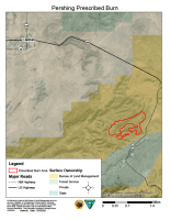
Continue reading BLM prescribed burn planned in Lincoln County
July 30, 2020 0 Comments
Beginning in August, the Bureau of Land Management (BLM) will be conducting prescribed burn operations about 10 miles northeast of Ruidoso and 6 miles southeast of Capitan in Lincoln County. The 206-acre Pershing slash pile unit is located within the Fort Stanton-Snowy River Cave National Conservation Area. This operation is weather dependent and will take […]
Continue readingKeep Fall Season Wildfire Safety in Mind, Oct. 7, 2019
October 7, 2019 0 Comments
As the fall season begins, land managers would like to remind the public to practice wildfire safety while enjoying the outdoors. Federal and state wildfire cooperators in New Mexico urge caution for those participating in hunting and other outdoor activities to go prepared to avoid sparking a fire. Just one small spark or heat from […]
Continue readingBLM, Fire Prevention, Fire Restrictions, Forest Service, Lincoln National Forest, National Park Service, New Mexico State Land Office, NM Fire Info, NM Game and Fish, NM State Forestry, Northcentral NM, Restrictions, Southeast NM, Southern New Mexico, Southern NM, Southwest NM, US Fish and Wildlife Service, USDI-BIA, West Central NM
Prescribed burn planned in Lincoln County
October 3, 2019 0 Comments
Beginning in October, the Bureau of Land Management (BLM) will be conducting prescribed burn operations about 10 miles northeast of Ruidoso and 6 miles southeast of Capitan in Lincoln County. The 1,130 acre project will take place within the Fort Stanton-Snowy River Cave National Conservation Area. These operations are weather dependent and will take several […]
Continue readingLincoln National Forest- Guadalupe Ranger District- Rawhide Fire 8/23/2019
August 23, 2019 0 Comments
Incident Name – Rawhide Fire Jurisdiction: Lincoln National Forest, Guadalupe Ranger District Size: 9214 Acres Cause: Lightning Date/Time Detected: Aug 8, 2019, 10:00 pm Location: 5 miles NW of Sitting Bull Falls near Rawhide Canyon. Values at Risk: None. Fire Update 8/23/2019: Smoke was visible the past two days on the Rawhide Fire as it […]
Continue readingLincoln National Forest- Smokey Bear Ranger District- Lone Mountain Fire Update 6/29/2019
June 29, 2019 0 Comments
Incident Name – Lone Mountain Fire Jurisdiction: Lincoln National Forest, Smokey Bear Ranger District Size: 1350 acres Cause: Lightning Date/Time Detected: May 26, 2019 Location: 6 miles north of White Oaks, NM. Lat/Long: 33.80809, -105.7386 Legal Description: T6S, R12E, SESW Sec 1 Fuel Type: Pinyon/Juniper, Grass, Ponderosa Pine Values at Risk: None Fire Update: The […]
Continue readingLincoln National Forest- Smokey Bear Ranger District- Lone Mountain Fire Update 6/28/2019
June 28, 2019 0 Comments
Incident Name – Lone Mountain Fire Jurisdiction: Lincoln National Forest, Smokey Bear Ranger District Size: 1100 acres Cause: Lightning Date/Time Detected: May 26, 2019 Location: 6 miles north of White Oaks, NM. Lat/Long: 33.80809, -105.7386 Legal Description: T6S, R12E, SESW Sec 1 Fuel Type: Pinyon/Juniper, Grass, Ponderosa Pine Values at Risk: None Fire Update: The […]
Continue reading


