

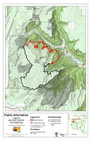
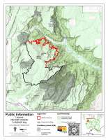
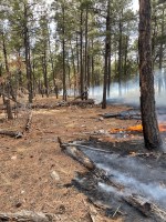
Strategic firing operations strengthen planned containment lines on Laguna Fire Acres: 16,934 Start Date: 06/25/2025 Location: Gallina, NM Cause: Lightning Personnel: 297 Fuels: Oak brush, Piñon-juniper, and mixed conifer Containment: 55% Resources: 2 crews | 9 engines | 4 helicopters | 2 unmanned aircraft system | 2 water tenders | 2 dozer | 3 ambulance […]
Continue reading
Archive | Active Wildfire RSS feed for this section


Laguna Wildfire Daily Update – July 22, 2025
 July 22, 2025
  0 Comments
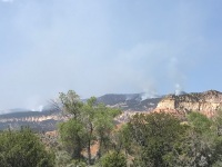
Aerial operations support full suppression efforts, increasing smoke in the area. Acres: 16,835 Start Date: 06/25/2025 Location: Gallina, NM Cause: Lightning Personnel: 320 Fuels: Oak brush, Piñon-juniper, and mixed conifer Containment: 55% Resources: 2 crews | 14 engines | 4 helicopters | 2 unmanned aircraft system | 2 water tenders | 2 dozer | […]
Continue readingLaguna Wildfire Daily Update – July 21, 2025
July 21, 2025 0 Comments
Planned fire operations may increase smoke in the area. Acres: 16,713 Start Date: 06/25/2025 Location: Gallina, NM Cause: Lightning Personnel: 325 Fuels: Oak brush, Piñon-juniper, and mixed conifer Containment: 55% Resources: 2 crews | 14 engines | 4 helicopters | 2 unmanned aircraft system | 5 water tenders | 2 dozer | 3 ambulance […]
Continue readingLaguna Wildfire Daily Update July 20, 2025
July 20, 2025 0 Comments
Increased smoke can be expected in the coming days as firefighters work to contain the fire. Acres: 16,713 Start Date: 06/25/2025 Location: Gallina, NM Cause: Lightning Personnel: 315 Fuels: Oak brush, Piñon-juniper, and mixed conifer Containment: 55% Resources: 2 crews | 14 engines | 4 helicopters | 2 unmanned aircraft system | 5 water […]
Continue reading Laguna Wildfire Daily Update – July 19, 2025
July 19, 2025 0 Comments
Smoke production is expected to increase this weekend. Acres: 16,004Start Date: 06/25/2025Containment: 47%Location: Gallina, NMCause: LightningPersonnel: 298Fuels: Oak brush, Piñon-juniper, and mixed coniferResources: 2 crews | 12 engines | 3 helicopters | 1 unmanned aircraft system | 4 water tenders | 2 dozer | 4 ambulance Highlights: Crews continue full suppression with strategic ignitions. Surrounding communities may experience and increase in smoke production […]
Continue reading Laguna Wildfire Daily Update – July 18, 2025
July 18, 2025 0 Comments
Acres: 16,004Start Date: 06/25/2025Containment: 44%Location: Gallina, NMCause: LightningPersonnel: 324Fuels: Oak brush, Piñon-juniper, and mixed coniferResources: 3 crews | 12 engines | 3 helicopters | 1 unmanned aircraft system | 3 water tenders | 2 dozer | 4 ambulance Highlights: Crews continue to prep and improve defensible space around cultural structures. Rain, heavy in some areas, […]
Continue reading Laguna Wildfire Daily Update – July 17, 2025
July 17, 2025 0 Comments
Southwest Area Incident Management Team 1 – Daily Update for July 16th, 2025 Acres: 15,714Start Date: 06/25/2025Containment: 44%Location: 4 miles northeast of Gallina, NMCause: LightningPersonnel: 286Fuels: Oak brush, Piñon-juniper, and mixed coniferResources: 4 crews | 9 engines | 3 helicopters | 1 unmanned aircraft system | 3 water tenders | 2 dozer | 4 ambulances […]
Continue reading Laguna Wildfire Daily Update – July 16, 2025
July 16, 2025 0 Comments
Southwest Area Incident Management Team 1 – Daily Update for July 16th, 2025 Acres: 15,714Start Date: 06/25/2025Containment: 40%Location: 4 miles northeast of Gallina, NMCause: LightningPersonnel: 291Fuels: Oak brush, Piñon-juniper, and mixed coniferResources: 5 crews | 8 engines | 4 helicopters | 1 unmanned aircraft system | 3 water tenders | 2 dozer | 4 ambulances […]
Continue reading Fire Start – Mountainair Ranger District (Manzano Unit)
March 18, 2025 0 Comments
New Fire Start on the Mountainair Ranger District:Ox Fire Reported start date / time: March 18, 2025 / 1600 Cause: Undetermined. Size: Approximately 3-4 acres Location: Manzano Mountains south of Ox Canyon within the 2007 Ojo Peak Fire scar on the Mountainair Ranger District – New Mexico – Cibola National Forest & National Grasslands. […]
Continue readingEncerrita Fire command transferred back to local unit due to decreased fire activity
June 25, 2024 0 Comments
El Malpais National Monument News Release For Immediate Release: June 25, 2024 Contact: El Malpais National Monument Visitor Center, 505-876-2783 Encerrita Fire command transferred back to local unit due to decreased fire activity GRANTS, NM — The Encerrita Fire again had very little activity on Monday as the area again received additional rainfall. The fire […]
Continue readingJune 24 Encerrita Fire Update, 10:00 a.m.
June 24, 2024 0 Comments
The Encerrita fire is 2,496 acres, and 0% contained. The fire area received more precipitation this weekend which kept fire activity at a minimum. On Sunday, the helicopter assigned to the incident flew the fire’s perimeter and observed minimal smoke and fire behavior. Firefighters continued line construction on the north and west sides of the […]
Continue readingFirefighters on the Encerrita Fire aided by wet weather
June 23, 2024 0 Comments
The 2,496 acres, 0% contained, Encerrita Fire has received a notable amount of precipitation over the past several days, with more precipitation in the forecast over the coming week. The previously issued “Ready” evacuation notice for residents north of the fire was rescinded on Saturday, June 22nd. The welcomed precipitation has significantly decreased fire […]
Continue readingEncerrita Fire area receives significant precipitation
June 22, 2024 0 Comments
El Malpais National Monument received significant precipitation yesterday with approximately 0.5” of rain falling in the area of the Encerrita Fire. Flooding was reported in the nearby town of Grants. The Encerrita Fire remains south and east of Highway 53. On Friday, before the rain event, firefighters were able to take advantage of favorable weather […]
Continue readingFrontal passage gives firefighters an edge on Encerrita Fire
June 21, 2024 0 Comments
For Immediate Release: June 21, 2024 Contact: El Malpais National Monument Visitor Center, 505-876-2783 Frontal passage gives firefighters an edge on Encerrita Fire Grants, NM —The Encerrita Fire only gained 3 acres on Thursday due to higher humidity that followed a frontal passage. The 2282-acre lightning-caused fire is located in El Malpais National Monument, 15 […]
Continue readingEncerrita Fire Update – Thursday June 20
June 20, 2024 0 Comments
As forecasted, winds ahead of the frontal passage Wednesday night led to increased fire activity on the lightning-caused Encerrita Fire, located 15 miles south-southwest of Grants. As the fire grew northward, pushed by a strong south wind, firefighters were able to hold the fire south and east of Highway 53. Crews were assisted by the […]
Continue readingEncerrita Fire Wednesday Evening Fire Update
June 19, 2024 0 Comments
Grants, NM – The Encerrita Fire was more active today due to gusty winds from the south resulting in the closure of Highway 53 south of Grants. The fire made a wind-driven run to the north that bumped the south side of the highway this afternoon. Fire is burning along the edge of the highway […]
Continue readingAdditional firefighters arrive to Encerrita Fire ahead of weather change
June 19, 2024 0 Comments
El Malpais National Monument News Release For Immediate Release: June 19, 2024 Contact: El Malpais National Monument Visitor Center, (505) 876-2783 Additional firefighters arrive to Encerrita Fire ahead of weather change Grants, NM —Additional crews arrived to the Encerrita Fire on Tuesday, bringing the total number of firefighters to 99 on the 1541-acre lightning-caused fire […]
Continue readingEncerrita Fire Update, June 18
June 18, 2024 0 Comments
Additional crews arrived on Monday and Tuesday morning to assist local firefighters working on the Encerrita Fire currently burning on El Malpais National Monument. The lightning-caused fire was discovered on June 15 and is estimated to be approximately 1300 acres as of Tuesday morning. The fire remains on NPS lands and does not pose an […]
Continue readingLightning-caused fire discovered on El Malpais National Monument
June 17, 2024 0 Comments
El Malpais National Monument News Release For Immediate Release: June 17, 2024 Contact: El Malpais National Monument Visitor Center, 505-876-2783 Grants, NM —National Park Service staff discovered a lightning-caused fire burning on El Malpais National Monument lands on the afternoon of Saturday, June 15. The Encerrita Fire, reported by the Oso Lookout, is located approximately […]
Continue reading Indios Fire Update, May 23, 2024
May 23, 2024 0 Comments
Acres: 851 Start Date: 5/19/2024 Location: 7 miles north of the village of Coyote, N.M. Personnel: 127 Containment: 0% Fuels: Timber, litter, understory Resources: 3 crews | 1 helicopter | 5 engines| 1 road grader | 2 masticators Highlights: The Northern New Mexico Type 3 team, Incident Commander Luke McLarty, assumed command of the […]
Continue reading


