
Location: On the north side of New Mexico Highway 511, approximately one mile south of the Colorado border. The area is entirely on BLM-managed lands. Reported start date: Aug. 13, 2023 at 7 p.m. Size: Approximately 70 acres Containment: A percentage of containment has not been set as this fire is being managed for resource benefits but crews are […]
Continue reading
Archive | Active Wildfire RSS feed for this section


West Fork Fire Final Update
 August 11, 2023
  0 Comments
Location: Eight miles north of Navajo Dam, near mile-marker 20. Reported start date: Aug. 7, 2023, at 5 p.m. Size: 43 acres Containment: 90 percent containment Cause: Lightning strike. Vegetation: Juniper, grass and brush. Fire Behavior: The West Fork Fire is exhibiting low fire behavior associated with winds produced by passing thunderstorms. Resources: Bureau of Land Management and San Juan County […]
Continue readingLake Fire Update – Aug. 8, 7pm
August 9, 2023 0 Comments
Location: Middle Mesa, northwest of Navajo Lake in San Juan County, N.M. The fire crosses lands managed by the Bureau of Land Management and the Bureau of Reclamation. Reported start date: Aug. 2, 2023 Size: 73 acres Containment: 90 percent contained. Cause: Lightning strike. Vegetation: Juniper, grass and brush. Fire Behavior: The Lake Fire is exhibiting low fire behavior associated […]
Continue readingLake Fire Update – Aug. 8
August 8, 2023 0 Comments
Location: Middle Mesa, northwest of Navajo Lake in San Juan County, N.M. The fire crosses lands managed by the Bureau of Land Management and the Bureau of Reclamation. Reported start date: Aug. 2, 2023 Size: 73 acres Containment: 75 percent contained. Cause: Lightning strike. Vegetation: Juniper, grass and brush. Fire Behavior: The Lake Fire is exhibiting low to moderate fire […]
Continue readingNEW: West Fork Fire, San Juan County, NM – Aug. 8
August 8, 2023 0 Comments
Location: Eight miles north of Navajo Dam, near mile-marker 20. Reported start date: Aug. 7, 2023, at 5 p.m. Size: Estimated 45 acres Containment: Zero percent containment Cause: Lightning strike. Vegetation: Juniper, grass and brush. Fire Behavior: The West Fork Fire is exhibiting moderate fire behavior associated with winds produced by passing thunderstorms. Resources: Bureau of Land Management and San Juan […]
Continue readingLake Fire Update – Aug. 7
August 7, 2023 0 Comments
Location: Middle Mesa, northwest of Navajo Lake in San Juan County, N.M. The fire crosses lands managed by the Bureau of Land Management and the Bureau of Reclamation. Reported start date: Aug. 2, 2023 Size: 73 acres Containment: 20 percent contained. The crews expect to reach 50 percent containment by this evening. Cause: Lightning strike Vegetation: Juniper, grass and […]
Continue readingPeppin Canyon Fire Final Update: 6/13/22, 9:15 am
June 13, 2022 0 Comments
Size: 2.5 acres Cause: Lightning Date/Time Detected: June 11, 2022, 3:00 pm Location: North side of the Capitan Wilderness. Map of the fire’s location: https://maps.nwcg.gov/sa/#/%3F/%3F/33.5984/-105.3212/12 Firefighting Resources: 1 wildland fire module, 1 engine, 1 repel crew, 2 helicopters. Fuel Type: The fire is in a burn scar and is consuming brush and dead-and-down and dead-standing […]
Continue readingPeppin Canyon Fire Update: 6/12/22, 11am
June 12, 2022 0 Comments
Jurisdiction: Lincoln National Forest, Smokey Bear Ranger District Size: 2.5 acres Cause: Lightning Date/Time Detected: June 11, 2022, 3:00 pm Location: North side of the Capitan Wilderness.Map of the fire’s location: https://maps.nwcg.gov/sa/#/%3F/%3F/33.5984/-105.3212/12 Firefighting Resources: 1 wildland fire module, 1 engine, 1 repel crew, 2 helicopters. Fuel Type: The fire is in a burn scar and is consuming […]
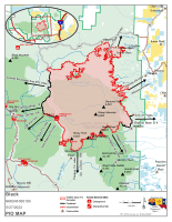
Continue readingBlack Fire Daily Update – May 30, 2022
May 30, 2022 0 Comments
Containment Increases on the Black Fire Despite Windy Conditions Daily Update 5/30/2022 Acres: 241,403 acres Location: 31 miles NW of Truth or Consequences Containment: 26% Personnel: 753 Start Date: Friday, May 13, 2022 Cause: Human-caused, under investigation Fuels: Timber and tall grass Structures Lost: 2 Overview: A real-time, interactive evacuation map is now available. The map provides current information on evacuation […]
Continue readingBlack Fire Update – May 29, 2022
May 29, 2022 0 Comments
Red flag conditions continue New interactive evacuation map available Daily Update 5/29/2022 Acres: 228,311 acres Location: 31 miles NW of Truth or Consequences Containment: 19% Personnel: 756 Start Date: Friday, May 13, 2022 Cause: Human-caused, under investigation Fuels: Timber and tall grass Structures Lost: 2 Overview: A new evacuation Area 12 has been added to […]
Continue reading Bear Trap Fire update for May 29, 2022
May 29, 2022 0 Comments
Acres: 38,225 acres Containment: 75% Cause: Undetermined Total Personnel: 357 Start Date: May 1, 2022 Location: San Mateo Mountains, Magdalena Ranger District, Socorro County, NM Fuels: Pine, Pinyon-Juniper and Grass Highlights: Fire lines were tested by high winds Saturday and held up well as more than three-quarters of the fire now is considered contained. Crews […]
Continue readingBlack Fire Evening Update – Updated Evacuations for March 28, 2022
May 28, 2022 0 Comments
Evacuation levels changing again Afternoon Update 5/28/2022 Announcement: Effective immediately, the Black Fire is implementing additional evacuations. In coordination with Sierra County Sheriff’s Office, the evacuation status for the following area have changed: Area 3: The northern most one-mile-wide piece is now in a GO evacuation. This includes the Murden property. The following areas are under […]
Continue readingBlack Fire Daily Update – May 28, 2022
May 28, 2022 0 Comments
Additional Evacuations Ordered Progress Made on the West and Northeast Sides of the Black Fire Daily Update 5/28/2022 Acres: 212,118 acres Location: 31 miles NW of Truth or Consequences Containment: 18% Personnel: 806 Start Date: Friday, May 13, 2022 Cause: Human-caused, under investigation Fuels: Timber and tall grass Structures Lost: 2 Overview: On the evacuation map, Area 11 that was in […]
Continue reading Black Fire Daily Update: 5/27/22
May 27, 2022 0 Comments
Firefighters working day and night to contain the Black FireCritical fire weather anticipated through the weekend Acres: 191,459 acres Location: 31 miles NW of Truth or Consequences Containment: 13% Personnel: 784 Start Date: Friday, May 13, 2022 Cause: Human-caused, under investigation Fuels: Timber and tall grass Structures Lost: 2 Overview: The Black Fire has over […]
Continue reading Bear Trap Fire update May 27, 2022
May 27, 2022 0 Comments
Acres: 38,091 acres Containment: 41% Cause: Undetermined Total Personnel: 428 Start Date: May 1, 2022 Location: San Mateo Mountains, Magdalena Ranger District, Socorro County, NM Fuels: Pine, Pinyon-Juniper and Grass Highlights: Thursday was a solid day on the Bear Trap Fire as crews patrolled fire containment lines and conducted mop up operations along the southern […]
Continue readingBlack Fire Daily Update: 5/26/22
May 26, 2022 0 Comments
Acres: 179,539 acres Containment: 13% Location: 31 miles NW of Truth or Consequences Personnel: 777 Structures Lost: 2 Fuels: Timber and tall grass Cause: Human-caused, under investigation Overview: Personnel conducted firing operations along Turkey Creek Road to keep the fire south of State Highway 59 and west of State Highway 52. The rugged nature, inaccessible […]
Continue readingBlack Fire Evacuation Update – 8 p.m. May 25, 2022
May 25, 2022 0 Comments
Additional evacuations issued on the Black Fire Afternoon Update 5/25/2022 8:00 pm Announcement: Effective immediately, the Black Fire is implementing additional evacuations. Evacuations: In coordination with Grant County Sheriff’s Office, the evacuation status for the following areas have changed: Area 8: The area east of Forest Road 150 is now in a GO evacuation. The area […]
Continue readingBlack Fire Evacuation Update – May 25, 2022
May 25, 2022 0 Comments
Evacuation Update: Effective at 10 pm, Tuesday, May 24, 2022, additional evacuations have been implemented because of fire activity on the Black Fire. In coordination with Grant, Catron, and Sierra counties, the following areas are under a level of evacuation status: GO – Area 1: New: The Area 1 Go has expanded north. The area […]
Continue readingBlack Fire Update – May 25, 2022
May 25, 2022 0 Comments
Evacuations updated as containment steadily increases; Warming trend will bring active fire behavior Daily Update 5/25/2022 Acres: 167,378 acres Location: 31 miles NW of Truth or Consequences Containment: 14% Personnel: 747 Start Date: Friday, May 13, 2022 Cause: Human-caused, under investigation Fuels: Timber and tall grass Structures Lost: 2 Evacuation Update: Effective at 10 pm, Tuesday, May 24, 2022, additional evacuations […]
Continue readingBlack Fire Update – May 24, 2022
May 24, 2022 0 Comments
Active Fire Behavior Continues; Red Flag Warning Issued Today Daily Update 5/24/2022 Acres: 154,911 acres Location: 31 miles NW of Truth or Consequences Containment: 11% Personnel: 646 Start Date: Friday, May 13, 2022 Cause: Human caused, under investigation Fuels: Timber and tall grass Structures Lost: 2 Overview: There is red flag warning in effect today from 12 pm-8 pm. A shift […]
Continue reading


