
 May 26, 2022
Acres: 179,539 acres
Containment: 13%
Location: 31 miles NW of Truth or Consequences
Personnel: 777
Structures Lost: 2
Fuels: Timber and tall grass
Cause: Human-caused, under investigation
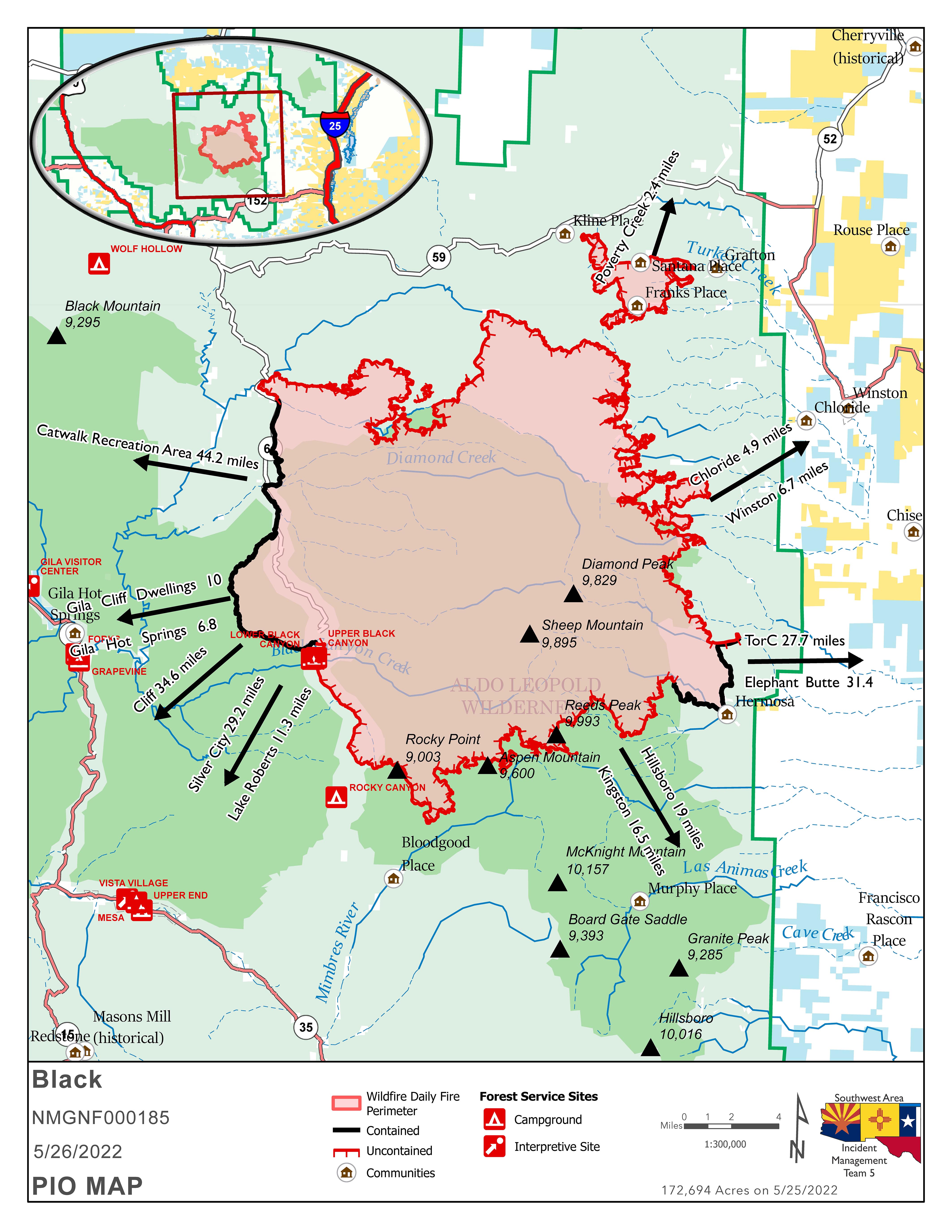
Overview: Personnel conducted firing operations along Turkey Creek Road to keep the fire south of State Highway 59 and west of State Highway 52. The rugged nature, inaccessible terrain, and the sheer size of the Black Fire makes gaining containment a slow process. The Black Fire encompasses more than 200 miles of containment lines, a distance that is farther than that of Truth or Consequences to Santa Fe.
Community Meeting: Thursday, May 26, 2022, at the Ralph Edward Civic Center 400 W 4th Street, Truth or Consequences, NM at 7:00 pm or watch it online at the Gila National Forest Facebook at https://www.facebook.com/GilaNForest. You do not need a Facebook account to view the meeting.
Fire Update: Overnight, personnel conducted firing operations northeast of the primary fire to keep the Black Fire south of Highway 59 and west of Highway 52. These operations were conducted in part by an Unmanned Aerial System (UAS) – also known as a drone, dropping spherical plastic balls that ignite when they hit the ground. The drone can cover more area in a shorter time than firefighters can on the ground, lowering the overall risk to pilots and firefighters. In combination with handlines, this firing operation created an area northeast of the fire to try to slow the fire’s progression.
Today: Expect the Black Fire to continue to move north and south. Crews are patrolling and monitoring after yesterday’s firing operations northeast of the main fire. South of the fire, a Structure Assessment Group is identifying homes, infrastructure, and outbuildings and ways to protect them. Crews are also preparing for firing operations south of the fire off Forest Road 150. Crews are scouting containment lines used on the Silver Fire in 2013 in hopes of utilizing them rather than creating new containment lines. Helicopters conducting bucket drops and super scooper aircraft using water from nearby lakes will be used on the north and south sides of the fire when needed. Fire activity on the east side of the fire has slowed over the past few days but will continue to progress into canyons as it finds vegetation to burn. Fire activity on the southeast corner of the fire near Hermosa has also slowed; however, crews continue to patrol the area for hotspots. Containment lines on the west side along Forest Road 150 continue to hold.
Weather: Temperatures will reach 90 degrees today. Winds will be lighter out of the west-southwest at 10 mph. Relative humidity will be 7%. This warming trend will bring critical fire weather as the week progresses.
Evacuation Update: The following areas are under evacuation status in coordination with Grant, Catron, and Sierra counties. Please reference the evacuation map.
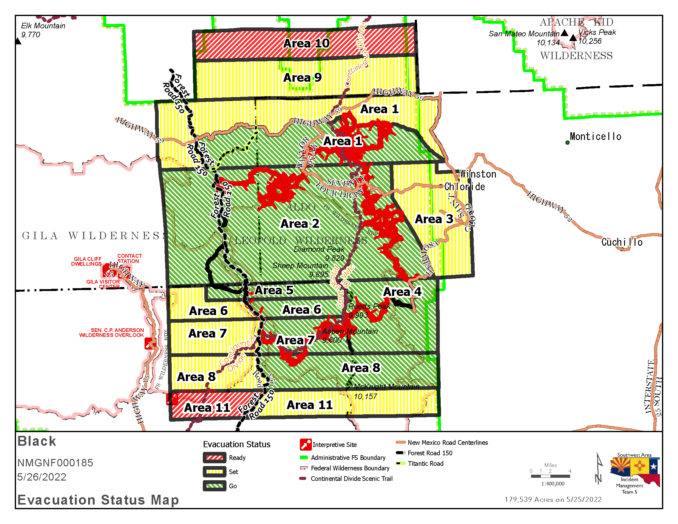
GO – Area 1: The area runs from Burnt Cabin west along the south side of NM Highway 59 to the junction with Forest Road 150, then south along the east side of Forest Road 150 back to where it connects back to Area 2.
Area 2: Existing area 2 evacuations remain in place.
Area 4: Areas in Sierra County, from the Continental Divide Scenic Trail to just east of the Gila National Forest Boundary, including Hermosa and Mud Spring Mountain.
Area 5: Areas in Grant County, including the Forest Road 150 corridor 1.5 south of Tom Moore Trailhead.
Area 6: East of Forest Road 150 to the Continental Divide Scenic Trail.
Area 7: East of Forest Road 150 to the Continental Divide Scenic Trail.
Area 8: The area east of Forest Road 150 to the Gila National Forest Boundary, including the Continental Divide Scenic Trail, Victorio Park Mountain, Flagpole Mountain, and Pack Trail.
SET –
Area 1: Encompassing parts of Catron and Sierra Counties, including Beaverhead and Poverty Creek.
Area 3: Areas in Sierra County, including Winston and Chloride.
Area 6: The area west of Forest Road 150 in Grant County.
Area 7: The area west of Forest Road 150, including the Rocky Canyon Campground.
Area 8: The area west of Forest Road 150, beginning at the south end of Area 7, approximately four miles south, and approximately 9-10 miles west.
Area 9: From the north edge of Area 1, running north along the Forest Boundary four miles, then east approximately 24 miles then south back to the Area 1 set northern edge.
Area 11: The area three miles south of the existing Area 8 on the east side of Forest Road 150. This includes Cooney, McKnight Cabin, the Continental Divide Scenic Trail, and Kelly Mesa.
READY –
Area 10: From the northern edge of Area 9, north three miles, then east approximately 24 miles, then south three miles to the edge of Area 9.
Area 11: From the southern edge of Area 8, south three miles and then east to Forest Road 150. This includes V Cross Ranch, Lake Roberts, and Roberts Dip.
The sheriffs of Grant, Catron, and Sierra counties use the Ready, Set, Go evacuation program. For more information, visithttps://www.emnrd.nm.gov/sfd/fire-prevention-programs/ready-set-go-new-mexico/
Road Closures: Highway 59 is closed from the 59/52 intersections west to the 59/150 intersection. Forest Road 150 is closed where it intersects Mimbres Trail. I-25 and other state highways remain open. As the fire continues to increase in size, a larger area closure is currently being identified that would better ensure fire fighter and public safety.
Smoke Outlook: Winston and surrounding area will see unhealthy conditions again today with periods of hazardous conditions in the mid-morning hours. Magdalena and Socorro will see good air quality in the morning, switching to moderate in the afternoon. Possible periods of Unhealthy for Sensitive Groups (USG) later in the afternoon with light winds out of the west-southwest. Truth or Consequences will see smoke impacts early this morning. Increased fire activity will produce periods of USG in the area late in the day. Low lying areas and drainages will see increased smoke. Caballo will see periods of USG smoke throughout the day. Gila Cliff Dwelling may see some periods of USG smoke with increased fire activity on the southwest part of the fire. Hanover will see USG smoke along the Mimbres river drainage later in the afternoon. Increased fire activity will bring periods of Unhealthy for Sensitive Groups (USG) south of the fire. Silver City will have good air quality for the early morning, switching to moderate mid-day.
Aviation Restrictions: Airtankers, helicopters, water scoopers, and Unmanned Aerial Systems are assisting firefighters’ suppression efforts. A 24-hour Temporary Flight Restriction (TFR) over the Black Fire restricts entry to non-fire aircraft, including civilian drones. Remember, if you fly, we can’t.
Fire Restrictions:
The Gila National Forest is under Stage 2 Fire Restrictions.
Visit https://www.fs.usda.gov/alerts/gila/alerts-notices/?aid=73002 for more information.
The New Mexico State Forester has implemented statewide fire restrictions. More information: https://www.emnrd.nm.gov/sfd/find-current-fire-restrictions/
More Information:
Inciweb: https://inciweb.nwcg.gov/incident/8103/
Facebook: https://www.facebook.com/GilaNForest
Twitter: https://twitter.com/gilanforest


Comments are closed.