
 May 24, 2022
Active Fire Behavior Continues; Red Flag Warning Issued Today
Daily Update 5/24/2022
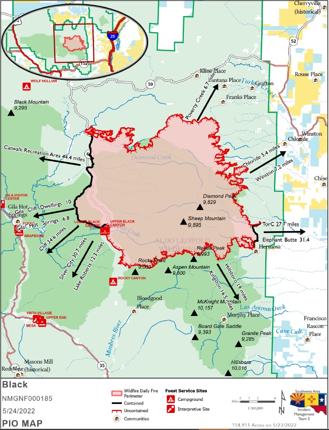
| Acres: 154,911 acres Location: 31 miles NW of Truth or Consequences Containment: 11% Personnel: 646 | Start Date: Friday, May 13, 2022 Cause: Human caused, under investigation Fuels: Timber and tall grass Structures Lost: 2 |
Overview: There is red flag warning in effect today from 12 pm-8 pm. A shift in winds may push the fire in different directions than the past week. Firefighters assisted by aircraft have been working to suppress this fire since it was discovered by building firelines ahead of the fire, as well as direct line closer to the fire where safely possible. Firefighters are challenged by the size of the fire, rough terrain and limited access.
Fire Update: The Black Fire showed active fire behavior Monday, with increased activity on the northeast side of the fire in Beyer’s Run and the southwest corner. Fire progression on the east has slowed.
Active fire behavior is anticipated on the northeast side of the fire today. North of the fire, crews continue to work on Road 59 by building firelines with bull dozers to prevent the fire from moving farther north. Firefighters will be conducting firing operations along Turkey Creek Road to strengthen firelines. Crews on the northwest side of the fire will be mopping up after firing operations yesterday and will continue to construct fireline along Titanic Road. Firefighters continue to identify structures in need of protection. The south side of the fire will back down into the Silver Fire scar. Crews are using Road 150 as a containment feature and continue to build firelines off it. As weather gets hotter, the fire is expected to make short uphill runs.
Evacuations: In coordination with Grant, Catron, and Sierra counties, the following areas are under evacuation status as of 3 pm on Sunday, May 22. Please reference the evacuation map.
GO – Area 1: New: Starting from Taylor Peak northeast to Kline Mountain, then east to Turkey Creek, following the Bear Creek Road southeast tying back into the north end of Area 3. The Area 1 portion, including Taylor Ranch and Alexander Peak, remains in GO. The line extends north along the Titanic Road, then east approximately eight miles before heading southeast, tying back into Area 2. The rest of Area 2 remains in Go. The rest of Area 1 remains in Set, and encompasses parts of Catron and Sierra Counties, including Beaverhead and Poverty Creek.
GO – Area 6: No Change: Area 6 east of Forest Road 150 is now in Go. The area west of Forest Road 150 remains in set. This area is in Grant County.
GO – Area 4: No Change: Areas in Sierra County, including Hermosa and Mud Spring Mountain.
GO – Area 5: No Change: Areas in Grant County, including 150 corridor 1.5 south of Tom Moore Trailhead.
GO – Area 7: Change: Area 7 east of Forest Road 150, including the Continental Divide Scenic Trail.
SET – Area 7: Change: Area 7 west of Forest Road 150, including the Rocky Canyon Campground.
SET – Area 3: No Change: Areas in Sierra County, including Winston and Chloride.
SET – Area 8: New: Area beginning at the south end of Area 7, four miles south, then east approximately 27 miles. The area now includes Victorio Park Mountain, Flagpole Mountain, and Pack Trail.
The sheriffs of Grant, Catron, and Sierra counties use the Ready, Set, Go evacuation program. For more information visit https://www.emnrd.nm.gov/sfd/fire-prevention-programs/ready-set-go-new-mexico/.
Weather: Today, winds will shift and blow from the west and northwest. A Red Flag Warning is in effect. Breezy west and southwest winds will return to the fire area on Friday through the weekend. Temperatures will continue to climb as the week goes on.
Road Closures: Highway 59, is closed from the 59/52 intersections west to the 59/150 intersection. Forest Service Road 150 is closed where it intersects Mimbres Trail. I-25 and other state highways remain open.
Smoke: Cloud cover will hold smoke close to the ground, keeping it from lifting and dissipating. Winston and surrounding areas will see unhealthy conditions again today with periods of hazardous air quality in the mid-morning hours. Magdalena and Socorro will see moderate to good air quality today. Increased fire activity will bring periods of Unhealthy Air Quality for Sensitive Groups south of the fire. Truth or Consequences will see smoke impacts late in the evening as winds switch to northwest.
Visit the Southern New Mexico Smoke Outlook website for additional information.
Aviation Restrictions: Airtankers, helicopters, and water scoopers are assisting firefighters’ suppression efforts. There is a Temporary Flight Restriction (TFR) over the Black Fire to allow official aviation resources to operate safely.
Fire Restrictions: The Gila National Forest is under Stage 2 Fire Restrictions. Visit https://www.fs.usda.gov/alerts/gila/alerts-notices/?aid=73002 for more information. The New Mexico State Forester has implemented statewide fire restrictions. More information: https://www.emnrd.nm.gov/sfd/find-current-fire-restrictions/.
More Information:
Inciweb: https://inciweb.nwcg.gov/incident/8103/
New Mexico Fire information: https://nmfireinfo.com/
Facebook: https://www.facebook.com/GilaNForest
Twitter: https://twitter.com/gilanforest
Phone Lines: Public: 575-249-1264; Media: 575-249-1294; Hours: 8 am – 8 pm
Email: 2022.black@firenet.gov


Comments are closed.