
 May 29, 2022
Red flag conditions continue
New interactive evacuation map available
Daily Update 5/29/2022
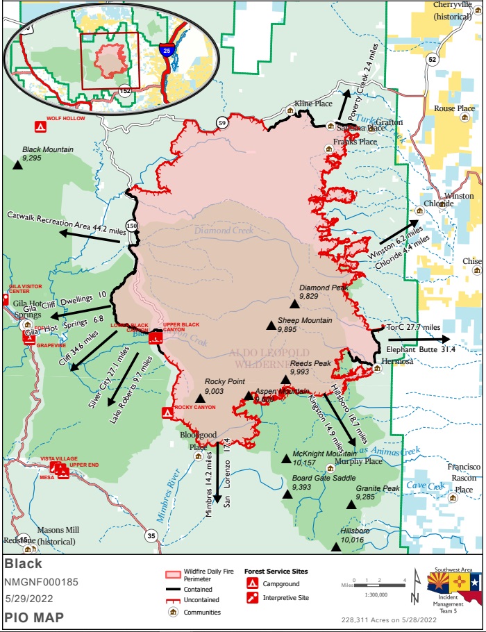
Acres: 228,311 acres
Location: 31 miles NW of Truth or Consequences
Containment: 19%
Personnel: 756
Start Date: Friday, May 13, 2022
Cause: Human-caused, under investigation
Fuels: Timber and tall grass
Structures Lost: 2
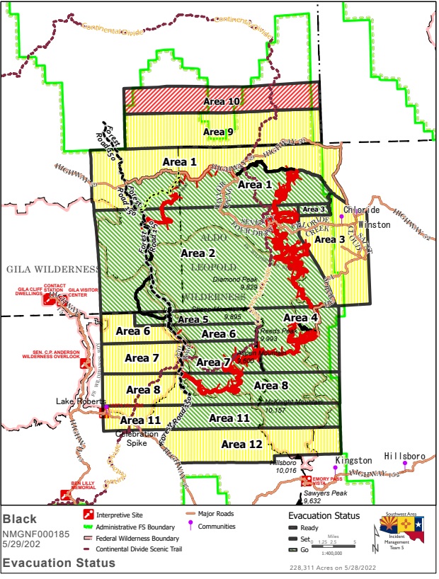
Overview: A new evacuation Area 12 has been added to SET. A real-time, interactive evacuation map is now available. The map provides the most up-to-date information available for evacuation status for the Black Fire. This new tool serves as a helpful resource for communities during the incident.
Fire Update: The Black Fire exhibited active fire behavior yesterday with extended downslope pushes through drainages on the east side of the Continental Divide, continued spread to the south through heavy dead and down fuels, and uphill runs on the northwest flank. Crews are constructing direct and indirect control lines, using hand and aerial ignitions to strengthen existing firelines, and patrolling and mopping up in several areas across the fire.
- North: Overnight, personnel worked to build on the success of yesterday’s operations, conducting hand and aerial ignitions to reduce fuel loads around Wall Lake and to the highway 70 control line. Today, active fire is expected through interior pockets of fuel within the Whitewater Canyon area on the northwest flank. Crews will patrol and secure the area, mopping up where needed.
- South: The Black Fire continues to burn within the Silver Fire scar. Today, firefighters will conduct hand ignitions to connect the fire’s edge along the Continental Divide Trail (CDT) to constructed control lines downslope. Crews will also secure Rocky Canyon and complete prepping infrastructure and other values at risk.
- East: Yesterday, active fire behavior was observed as it continued moving toward the Mineral Creek area. Last night, hand ignition operations were conducted near Hermosa to respond to the rapidly moving main fire. Today, fire is expected to spread downslope, up to 1-2 miles, within the Palomas Creek drainage and the Mineral Creek area. Firefighters will continue to monitor and work to secure the area.
- West: Containment lines continue to hold. Crews will patrol, secure, and monitor the fire perimeter south of Meown along Forest Road 150 and areas to the northwest where overnight burn operations were conducted.
Weather: Red flag warning continues. High temperatures, gusty winds, and low humidity add to active fire behavior. Temperatures: 81-85 degrees. Winds: Gusts up to 40mph from the southwest. Relative Humidity: 7-11%.
Evacuation Update: The following areas are under evacuation status Grant, Catron, and Sierra counties. Please reference the Ready, Set, Go evacuation map, or view the interactive map.
GO –
Area 1: The area runs from Burnt Cabin west along the south side of NM Highway 59 to the junction with
Forest Road 150, then south along the east side of Forest Road 150 back to where it connects back to
Area 2.
Area 2: Existing area 2 evacuations remain in place.
Area 3: The northernmost one-mile-wide piece is now in a GO evacuation. This includes the Murden
property.
Area 4: Areas in Sierra County, from the Continental Divide Scenic Trail to just east of the Gila National Forest
Boundary, including Hermosa and Mud Spring Mountain.
Area 5: Areas in Grant County, including the Forest Road 150 corridor 1.5 south of Tom Moore Trailhead.
Area 6: East of Forest Road 150 to the Continental Divide Scenic Trail.
Area 7: East of Forest Road 150 to the Continental Divide Scenic Trail.
Area 8: The area east of Forest Road 150 to the Gila National Forest Boundary, including the Continental
Divide Scenic Trail, Victorio Park Mountain, Flagpole Mountain, and Pack Trail.
Area 11: South of Area 8 on the east side of Forest Road 150. This includes Cooney, McKnight Cabin, The
Continental Divide Scenic Trail and Kelly Mesa.
SET –
Area 1: Encompassing parts of Catron and Sierra Counties, including Beaverhead and Poverty Creek.
Area 3: The remaining areas in Sierra County, including Winston and Chloride.
Area 6: The area west of Forest Road 150 in Grant County.
Area 7: The area west of Forest Road 150, including the Rocky Canyon Campground.
Area 8: The area west of Forest Road 150, beginning at the south end of Area 7, then approximately four miles south, and approximately 9-10 miles west.
Area 9: From the north edge of Area 1, running north along the Forest Boundary four miles, east approximately 24 miles, then south back to the Area 1 set northern edge.
Area 11: The area south of Area 8 on the west side of Forest Road 150. This includes V Cross Ranch, Lake Roberts, and Sapillo Campground.
Area 12: South of Area 11. East of Forest Road 150 and east of State Highway 35 and Forest Road 150, approximately 4 miles wide, including private property on the east side of the Highway 35 and Forest Road 150.
READY –
Area 10: From the northern edge of Area 9, north three miles, then east approximately 24 miles, then south three miles to the edge of Area 9.
The sheriffs of Grant, Catron, and Sierra counties use the Ready, Set, Go evacuation program. For more information, visit https://www.emnrd.nm.gov/sfd/fire-prevention-programs/ready-set-go-new-mexico/
Closures: Highway 59 is closed from Mud Hole west to the 59/150 intersection Poverty Creek residents may access their property. Forest Road 150 is also closed at the North Star Helispot due to fire activity. I-25 and other state highways remain open. As a result of continued fire growth, an area closure has been implemented for public and firefighter safety. Visit: https://www.fs.usda.gov/alerts/gila/alerts-notices/?aid=73018 for additional information.
Smoke: Magdalena will continue to see good air quality in the area most of the day, with west-southwest winds pushing smoke to the northeast. Socorro will see periods of moderate to USG (unhealthy for sensitive groups) with west southwest winds pushing smoke northeast. Winston and Chloride will start the day with USG air quality clearing as winds pick up around noon. This morning, Gila Cliff Dwellings will see good air quality with periods of moderate smoke backing into areas when the winds change out of the northwest to west-southwest. Mimbres, Hanover, and San Lorenzo along the Mimbres River drainage will see Good Air Quality with high winds from the southwest, clearing out the drainages and low-lying areas. Truth or Consequences and Caballo will have moderate air quality with possible periods of USG. Blowing dust and debris will also reduce air quality and visibility today. Current Smoke Outlook for Southern New Mexico (airfire.org).
Aviation Restrictions: Aircraft are assisting firefighters’ suppression efforts as weather conditions allow. A 24-hour Temporary Flight Restriction (TFR) over the Black Fire restricts entry to non-fire aircraft, including civilian drones. Unauthorized aircraft could lead fire managers to suspend aerial wildfire suppression operations until the aircraft has left the airspace and they are confident it won’t return. Suspending air operations could decrease the effectiveness of wildfire suppression operations, allowing wildfires to grow larger, and in some cases, unduly threaten lives, property, and valuable natural and cultural resources. Remember, if you fly, we can’t.
Fire Restrictions:
- The Gila National Forest in Stage 2 Fire Restrictions: https://www.fs.usda.gov/alerts/gila/alerts-notices/?aid=73002
- NM Forestry Division state-wide fire restrictions: https://www.emnrd.nm.gov/sfd/find-current-fire-restrictions/
More Information:
- New Mexico Fire information: https://nmfireinfo.com/
- Facebook: https://www.facebook.com/GilaNForest
- Twitter: https://twitter.com/gilanforest
- Smoke Info: https://outlooks.airfire.org/outlook/dde9ec52
- NM Road Information: www.nmroads.com/
- Interactive Evacuation Map: https://nifc.maps.arcgis.com/apps/webappviewer/index.html?id=d375d3d880a649aa914f693db309b892
- Area Closure: https://www.fs.usda.gov/alerts/gila/alerts-notices/?aid=73018


Comments are closed.