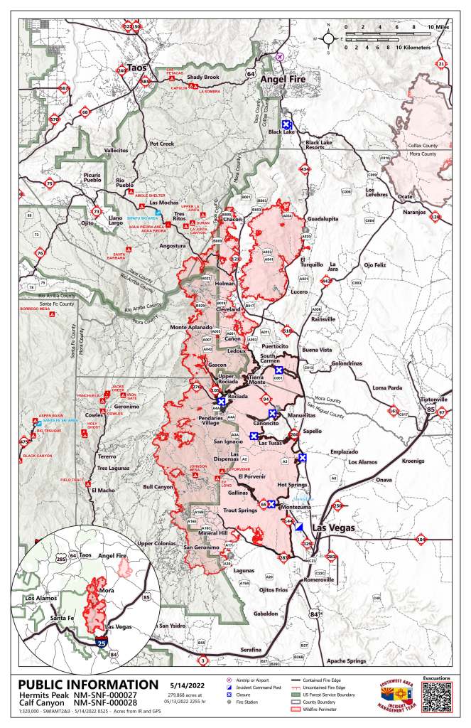
May 14, 2022, Daily Update, 09:00AM

Acres: 279,868 acres – Containment: 27% – Total personnel: 1,924
Start Date: Hermits Peak: April 6, 2022; Calf Canyon: April 19, 2022
Cause: Hermits Peak: spot fires from prescribed burn; Calf Canyon: under investigation
Location: Located near Gallinas Canyon – Fuels: Heavy mixed conifer, ponderosa pine, brush, and grass
Highlights: Today, the incoming Type 1 Southwest Incident Management Team 1 (SWIMT 1) and Type 1 California Team 2 are shadowing the current teams to ensure a seamless transition Sunday. Active fire behavior is predicted today with critically dry relative humidity and higher temperatures; however, with less wind, the fire isn’t expected to grow significantly. Yesterday, every aircraft assigned to the incident was over the fire throughout the day. With similar conditions today, helicopters and fixed-wing aircraft will be up again to support the firefighters on the ground. Residents of San Miguel, Mora, Taos, and Colfax counties should remain on high alert for changes to evacuation statuses and road closures.
Operations: On the north, structure protection crews are working around Angostura to prepare homes and values as fire pushes toward the Angostura Trail today. Firefighters are working in the areas of Chacon, Holman, Cleveland, and Mora along the fire’s edge to mitigate impacts. Yesterday, the fire stayed out of the Chacon valley as it moved north. Above Mora, crews are constructing additional dozer lines as the fire backs down Comanche Canyon. Firefighters continue to work in the Highway 518, 121, 434, and 442 corridors up to and around Black Lake. Today, the fire is predicted to end up near Guadalupita South, and structure protection groups are doing lots of work there. Crews worked west from the Cooks Peak Fire and east from the Hermits Peak and Calf Canyon fire to open dozer lines and connect roads, meeting in the middle. Towards Highway 442, crews are finishing tying in line with Martinez Ranch Road.
On the south, crews are monitoring around Mineral Hills and San Geronimo to make sure nothing else is threatened. The fire remains active around Barillas Peak. Large and Very Large Air tankers (LATs and VLATs) were able to drop retardant on that line yesterday to assist ground crews. Firefighters are working directly on this edge, and additional lines are being constructed to the south. Crews are also creating a dozer line to the wilderness boundary above Bull Canyon and connecting some roads and trails. The fire has crossed the crest at Elk Mountain and is moving slowly into an old fire scar. There will be a lot of smoke coming from this area. Around Rociada and Gascon, firefighters are still working to secure the fire’s edge. The fire continues to move into the Pecos Wilderness in areas along the northwestern side.
Evacuations: For an interactive map collection, including the evacuation map, scan the QR code at the top of the page or go to https://tinyurl.com/HermitsPeak. Follow Taos County (https://www.facebook.com/profile.php?id=100064642843163), San Miguel County (www.facebook.com/smcso.nm), and Mora County (www.facebook.com/moracountysheriffoffice) Sheriff’s Office Facebook pages for the latest updates.
Weather: On the southern end, west to southwest winds 15 to 20 mph, gusts to 27. On the northern end, north to northwest winds 10 to 15 mph, gusts to 28. Maximum temperatures upper 60’s to mid-80’s. Minimum relative humidity 5 to 13%.
Restrictions: A new Carson National Forest closure order includes the entire Camino Real Ranger District. Forest-wide Stage 2 fire restrictions have been implemented. Full closure order and map: www.fs.usda.gov/alerts/carson/alerts-notices
The Santa Fe National Forest closure order includes the entire Pecos/Las Vegas Ranger District. Forest-wide Stage 2 fire restrictions have been implemented. Full closure order and map: www.fs.usda.gov/detail/santafe/alerts-notices/?cid=stelprd3802009.
Smoke: An interactive smoke map at https://fire.airnow.gov/ allows you to zoom into your area to see the latest smoke conditions.
Fire Information: Fire Information Office Hours: 8:00 AM – 8:00 PM | Phone: 505-356-2636 | Email: 2022.hermitspeak@fire.gov Inciweb (inciweb.nwcg.gov/incident/8069/) |SFNF Facebook| Twitter| SFNF website|New Mexico Fire Information website.
# # #


 May 14, 2022


Comments are closed.