
 July 2, 2026
July 2, 2026
Northern New Mexico Type 3 Incident Management Team
STEVEN GRIEGO – INCIDENT COMMANDER
Acres: 4,291 Start Date: June 26, 2026
Containment: 0% Fuels: Timber, grass and understory
Cause: Undetermined Personnel: 252
Location: 15 miles west of Tres Piedras, north of Hwy 64
Highlights: Cooler temperatures and recent precipitation have moderated fire behavior, enabling firefighters to secure and hold portions of the fire perimeter. Firefighters are taking advantage of these favorable conditions and continue to strengthen and secure fire lines where needed. Updated perimeter mapping reflects recent UAS (unmanned aircraft system) infrared data and completed firing operations, providing a more accurate representation of the fire’s size and extent. Light smoke may still be visible as interior fuels continue to consume within the perimeter, even in areas with little to no active fire growth. As suppression objectives are met, firefighters are beginning suppression repair in portions of the fire area. A road closure for the Beehive Fire remains in effect until further notice for public safety.
Operations: Yesterday, crews completed planned firing operations along the western perimeter to remove unburned vegetation between the fire’s edge and established fire line, further strengthening containment. Firefighters continue to patrol, hold, and secure established fire lines. Crews are also conducting mop-up operations, extinguishing remaining hotspots to prevent further fire spread. On the southeastern flank, firefighters have transitioned to suppression repair activities, including repairing established fire lines, naturalizing disturbed areas and implementing measures to reduce erosion and other impacts from suppression efforts where firefighting operations are complete.
Smoke: For current smoke conditions, view the interactive smoke map at https://fire.airnow.gov/. Learn more about protecting yourself from wildfire smoke and its health impacts at https://nmtracking.org/environment/air/FireAndSmoke.html.
Weather: Thursday will be even drier than Wednesday, with single-digit humidity expected for up to six hours and breezy southwest winds returning. These conditions can quickly dry vegetation, increase fire activity in unburned interior pockets and carry smoke farther downwind. The warmer, drier pattern is expected to continue through the end of the week and could challenge containment and holding efforts, making continued patrol, mop-up and securing of fire lines especially important.
Safety: For your safety, visitors should be aware of ongoing fire suppression activities in the Hopewell Lake area, where crews are using heavy equipment and aircraft to support firefighting operations. Hikers on the Continental Divide National Scenic Trail are encouraged to bypass the section between Hopewell Lake and the Rio Grande National Forest until fire activity and suppression operations have subsided. Motorists are urged to slow down and use caution on Highways 64 and 285, where periods of heavy smoke may reduce visibility and create hazardous driving conditions.
Fire Restrictions & Closures: A Beehive Fire road closure is in effect as of yesterday, July 1, 2026. The closure includes Forest Service Roads 83, 421, 576 and 133, from Highway 64 to its intersection with Forest Service Road 133E1. The Carson National Forest is currently in Stage 2 fire restrictions. You can find more information at: https://bit.ly/CarsonNF-Fire-Restrictions. Fireworks are ILLEGAL on National Forest Land. Violating this regulation poses a great risk for wildland fire potential and public safety.
Fire Information: 505-278-7205/ www.facebook.com/CarsonNF / 2026.beehive.nm@firenet.gov / nmfireinfo.com / https://bit.ly/Beehive-Fire-2026
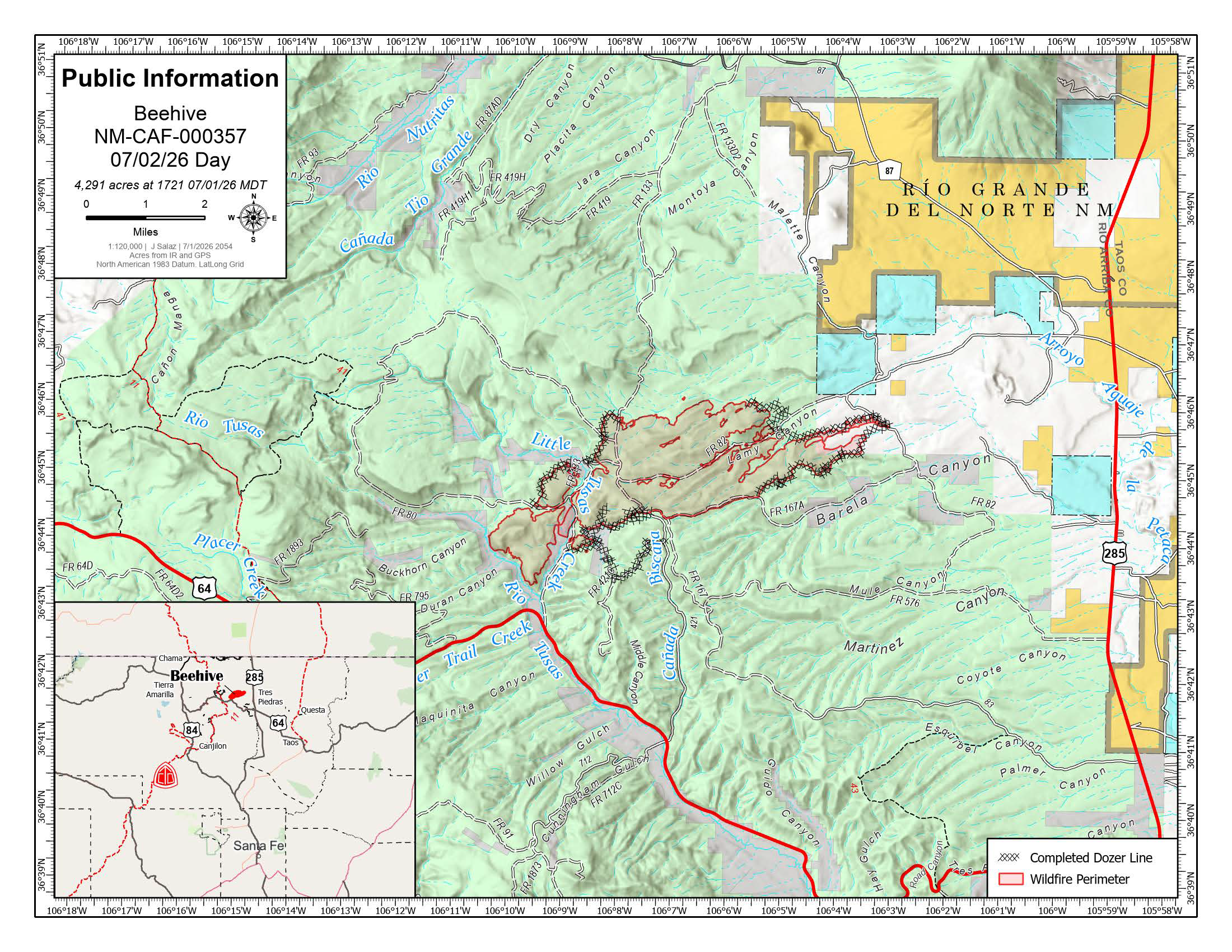
Updated public information map for the Beehive Fire as of July 2, 2026. The fire is estimated at 4,291 acres and remains north of Highway 64 in the Tusas Valley, approximately 15 miles west of Tres Piedras, New Mexico. The map displays the current wildfire perimeter and completed dozer line locations supporting containment efforts.


Comments are closed.