
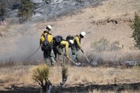
ROSWELL, N.M. – In March, the Bureau of Land Management plans to conduct a prescribed burn operation about 33 miles northwest of Roswell in Chaves County. The operation will take place within an area of 587 acres but will only burn about 25% of the land within that area. The operation is weather dependent and […]
Continue reading
Tag Archives: BLM

BLM plans prescribed burn activities in Eddy County
 February 21, 2026
  0 Comments
CARLSBAD, N.M. – Beginning in February, the Bureau of Land Management plans to conduct prescribed burn operations in Eddy County. Specifically, the BLM plans operations at the Black River Recreation Area on 105 acres; at Cottonwood Springs south of Carlsbad on 350 acres; and at Hay Hollow on 105 acres. The operations, which may continue […]
Continue readingBLM plans prescribed burn activities in Lincoln County
February 17, 2026 0 Comments
ROSWELL, N.M. – Beginning in February, the Bureau of Land Management plans to conduct prescribed burn operations in Lincoln County. Specifically, the BLM plans operations at the Fort Stanton – Snowy River Cave National Conservation Area on 2,026 acres within four burn units. The operations, which will continue through March, are weather dependent and will take […]
Continue readingCamp Fire Update 5/29/25: Command of the Camp Fire Transitions Back to BLM
May 29, 2025 0 Comments
This will be the last fire update for the Camp Fire unless there is a significant change. Acres: 877 Cause: Under investigation Containment: 76% Total personnel: 69 Structures Damaged: 5Start Date: May 25, 2025 Location: Fort Stanton – Snowy River Cave National Conservation Area Fire Update Command of the Camp Fire, which started on Sunday, […]
Continue readingCamp Fire Update 5/28/25: Rob Jaggers Campground and Fort Stanton Reopen Tomorrow
May 28, 2025 0 Comments
Acres: 877 Cause: Under investigation Containment: 70% Total personnel: 120 Structures Damaged: 4Start Date: May 25, 2025 Location: Fort Stanton – Snowy River Cave National Conservation Area Fire Update Containment continues to increase as crews make progress on securing the fire line. The fire has not spread for several days however, after more accurate GIS […]
Continue reading Camp Fire Evening Update 5/27/25: Containment Jumps to 47% on the Camp Fire
May 27, 2025 0 Comments
Acres 720 Cause: Under investigation Containment: 47% Total personnel: 147 Structures Damaged: 4 Start Date: Sunday, May 25, 2025Location: Fort Stanton – Snowy River Cave National Conservation Area Fire Update Crews made significant progress today securing large portions of the fire line on the north and south sides of the fire. Fire containment increased to […]
Continue readingCamp Fire Morning Update 05/27/25: Crews Secure Fire Lines on the Camp Fire
May 27, 2025 0 Comments
Acres: 720 Cause: Under investigation Containment: 4%Total personnel: 147 Structures Damaged: 4Start Date: May 25, 2025 Location: Black Jack Pershing Rd. and Bonito Loop, Fort Stanton, NM Fuels: Pinon-juniper, grass Fire Update Fire lines continue to hold. There was no fire spread overnight. Today fire crews will continue to secure the perimeter of the fire […]
Continue reading BLM implements fire restrictions at Fort Stanton – Snowy River NCA and Lincoln Tracts
March 10, 2025 0 Comments
Due to high fire danger and prolonged drought, the Bureau of Land Management (BLM) is implementing fire restrictions on public land at the Fort Stanton – Snowy River Cave National Conservation Area and BLM lands around the community of Lincoln. The restrictions go into effect at 8 a.m. March 10 and will remain in effect until further notice.
Continue readingPrescribed fire planned in Lincoln County (July-Sept. 2021)
July 8, 2021 0 Comments
Beginning this week, and continuing through September, the Bureau of Land Management (BLM) will conduct prescribed fire operations about 10 miles northeast of Ruidoso and 6 miles southeast of Capitan in Lincoln County. The 714-acre Zamora slash pile unit is located within the Fort Stanton-Snowy River Cave National Conservation Area. This operation is weather dependent […]
Continue readingBLM New Mexico restricts exploding targets
March 9, 2021 0 Comments
The Bureau of Land Management New Mexico State Office has issued a fire prevention order prohibiting the use of exploding targets on BLM-managed lands throughout the state. The order takes effect on March 10, 2021 and expires on Dec. 31, 2021. Exploding targets are commercially available binary explosives commonly consisting of ammonium nitrate and […]
Continue readingPrescribed burn planned for Sandoval County Spring 2020
January 15, 2020 0 Comments
Beginning Jan. 24 thru April 30, the Bureau of Land Management’s (BLM) Rio Puerco Field Office will conduct a prescribed burn at the Perea Nature Area on approximately 20 acres of salt cedar and Russian olive tree piles. The project is located along the Perea Nature Trail, which is within the Rio Salado Riparian area, […]
Continue readingBLM to implement prescribed fire in McKinley and Sandoval counties
November 21, 2019 0 Comments
Beginning Nov. 25 – Dec. 23, the Bureau of Land Management Rio Puerco Field Office, in cooperation with the New Mexico Department of Game and Fish, plans to conduct the Mesa Chivato prescribed fire on approximately 500 acres within the Ignacio and Chamisa Wilderness Study Areas. Fire managers estimate it will take approximately 2-4 days to […]
Continue readingNPS and BLM Conduct Prescribed Fire at El Malpais National Monument
June 19, 2019 0 Comments
The National Park Service at El Malpais National Monument and the Bureau of Land Management’s El Malpais National Conservation Area are conducting a prescribed fire on the west side of the national monument near the junction of County Road (CR) 42 and the Big Tubes turn-off. This prescribed burn is being called the Rendija Fire […]
Continue readingBLM to Continue Prescribed Fire in Cibola County in May-June
May 9, 2019 0 Comments
This month and into June, the Bureau of Land Management Rio Puerco Field Office plans to continue a prescribed fire in Cibola County, weather permitting. The burn, which will occur in the 4,000 acre Chain of Craters-Rendija prescribed fire project, will be conducted in several phases. The project area is located within the El Malpais […]
Continue readingBLM Prescribed Burn Planned in Lincoln County
September 1, 2016 0 Comments
Prescribed Burn Planned in Lincoln County Beginning in September 2016, the Bureau of Land Management (BLM) will be conducting prescribed burn operations about 10 miles northeast of Ruidoso in Lincoln County within the Fort Stanton-Snowy River Cave National Conservation Area. The Bench Three prescribed fire will be 350 acres of hand piles above the […]
Continue readingBLM Plans Prescribed Burn in Socorro County
April 21, 2016 0 Comments
BLM Plans Prescribed Burn in Socorro County Socorro, NM – The Bureau of Land Management’s Socorro Field Office is planning a prescribed burn of up to 100 acres in Socorro County between late April and the end of May, weather permitting. The burn includes the 100 acre Wolf Wells Prescribed Burn located 12 miles […]
Continue reading


