
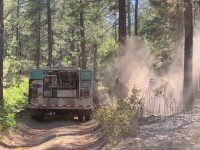
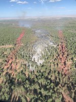
Aerial operations support full suppression efforts, increasing smoke in the area. Acres: 16,835 Start Date: 06/25/2025 Location: Gallina, NM Cause: Lightning Personnel: 320 Fuels: Oak brush, Piñon-juniper, and mixed conifer Containment: 55% Resources: 2 crews | 14 engines | 4 helicopters | 2 unmanned aircraft system | 2 water tenders | 2 dozer | […]
Continue reading
Tag Archives: wildfire
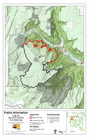


Laguna Wildfire Daily Update – July 21, 2025
 July 21, 2025
  0 Comments
Planned fire operations may increase smoke in the area. Acres: 16,713 Start Date: 06/25/2025 Location: Gallina, NM Cause: Lightning Personnel: 325 Fuels: Oak brush, Piñon-juniper, and mixed conifer Containment: 55% Resources: 2 crews | 14 engines | 4 helicopters | 2 unmanned aircraft system | 5 water tenders | 2 dozer | 3 ambulance […]
Continue reading Laguna Wildfire Daily Update – July 19, 2025
July 19, 2025 0 Comments
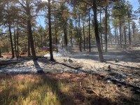
Smoke production is expected to increase this weekend. Acres: 16,004Start Date: 06/25/2025Containment: 47%Location: Gallina, NMCause: LightningPersonnel: 298Fuels: Oak brush, Piñon-juniper, and mixed coniferResources: 2 crews | 12 engines | 3 helicopters | 1 unmanned aircraft system | 4 water tenders | 2 dozer | 4 ambulance Highlights: Crews continue full suppression with strategic ignitions. Surrounding communities may experience and increase in smoke production […]
Continue reading Paradise Fire for June 1, 2025
June 1, 2025 0 Comments
Now at 87% Containment Acres: 727 Start Date: Monday, May 26, 2025 Location: 13 miles south of Quemado, NM Personnel: 125 Containment: 87% Cause: Human-caused, under investigation Summary: The Paradise Fire north of Quemado Lake is holding at 727 acres and is now 87% contained. Firefighters have completed dozer line repair work and chipping and […]
Continue reading Paradise Fire Update for May 31
May 31, 2025 0 Comments
Now 74% Contained Acres: 727 Start Date: Monday, May 26, 2025 Location: 13 miles south of Quemado, NM Personnel: 127 Containment: 74% Cause: Human-caused, under investigation Summary: The Paradise Fire is now 74% contained. This morning, Incident Commander Marcus Cornwell transferred command of the Gila Las Cruces Type 3 Incident Management Team to Dustin Roper. […]
Continue reading Paradise Fire update for May 30
May 30, 2025 0 Comments
Now 30% Contained Acres: 727 Start Date: Monday, May 26, 2025 Location: 13 miles south of Quemado, NM Personnel: 147 Containment: 30% Cause: Human-caused, under investigation Summary: The Paradise Fire is holding at 727 acres, and crews have increased containment to 30%. Firefighters are working to hold and secure fire lines, while mopping up areas […]
Continue readingEncerrita Fire Update, June 18
June 18, 2024 0 Comments
Additional crews arrived on Monday and Tuesday morning to assist local firefighters working on the Encerrita Fire currently burning on El Malpais National Monument. The lightning-caused fire was discovered on June 15 and is estimated to be approximately 1300 acres as of Tuesday morning. The fire remains on NPS lands and does not pose an […]
Continue readingLightning-caused fire discovered on El Malpais National Monument
June 17, 2024 0 Comments
El Malpais National Monument News Release For Immediate Release: June 17, 2024 Contact: El Malpais National Monument Visitor Center, 505-876-2783 Grants, NM —National Park Service staff discovered a lightning-caused fire burning on El Malpais National Monument lands on the afternoon of Saturday, June 15. The Encerrita Fire, reported by the Oso Lookout, is located approximately […]
Continue readingNew Mexicans Have Tough Choices
June 24, 2022 0 Comments
Today, the Gila National Forest lifted fire restrictions. While the fire danger on the forest has decreased from “extreme” to “moderate”, the potential for large wildfires remains. The public is urged to remain vigilant when they visit the forest. Remember to use any fire source in a cautious manner. Never leave a campfire unattended. When […]
Continue readingGila National Forest Lifts Stage II Fire Restrictions
June 24, 2022 0 Comments
Silver City, NM – June 24 — The Gila National Forest has lifted all fire restrictions as of 8:00 a.m. today. Forest leadership made the decision to lift stage II restrictions based on several factors, including a favorable monsoonal weather forecast, lesser occurrence of human caused wildfires, and adequate firefighting staffing. Fire managers will continue […]
Continue readingNew Start-Peppin Canyon Fire, Lincoln National Forest
June 11, 2022 0 Comments
Incident Name – Peppin Canyon Fire Jurisdiction: Lincoln National Forest, Smokey Bear Ranger District Size: 2 acres Date/Time Detected: June 11, 2022, 3:00 pm Cause: Lightning Location: North side of the Capitan Wilderness Firefighting Resources: County and Forest Service firefighting resources. Type 3 helicopter. Air Attack. Fuel Type: The fire is in a burn scar and is […]
Continue reading Bear Trap Fire update for May 29, 2022
May 29, 2022 0 Comments
Acres: 38,225 acres Containment: 75% Cause: Undetermined Total Personnel: 357 Start Date: May 1, 2022 Location: San Mateo Mountains, Magdalena Ranger District, Socorro County, NM Fuels: Pine, Pinyon-Juniper and Grass Highlights: Fire lines were tested by high winds Saturday and held up well as more than three-quarters of the fire now is considered contained. Crews […]
Continue reading Bear Trap Fire update May 27, 2022
May 27, 2022 0 Comments
Acres: 38,091 acres Containment: 41% Cause: Undetermined Total Personnel: 428 Start Date: May 1, 2022 Location: San Mateo Mountains, Magdalena Ranger District, Socorro County, NM Fuels: Pine, Pinyon-Juniper and Grass Highlights: Thursday was a solid day on the Bear Trap Fire as crews patrolled fire containment lines and conducted mop up operations along the southern […]
Continue readingGila NF: Johnson Fire Update for June 11, 2021
June 11, 2021 0 Comments
Friday, June 11, 2021 Visit the New Mexico Fire Information website at http://www.nmfireinfo.com Inciweb: https://inciweb.nwcg.gov/incident/7493/ Fire Phone 575-519-0103 JOHNSON FIRE Location: Johnson Canyon, west of McKenna Park. 11 miles west of Gila Cliff Dwellings, Wilderness Ranger District, Catron County, NM Start Date: May 20, 2021 Size: ~ 50,384 Cause: Lightning […]
Continue readingGila NF: Drummond Fire Update, June 10, 2021
June 10, 2021 0 Comments
Date: June 10, 2021 Announcement: Unless significant fire activity increases on the Drummond Fire, news releases will occur only as changes develop during the next week. Location: The Drummond Fire is one mile south of Emory Pass on the Gila National Forest, Black Range Ranger District, Sierra County, NM Start Date: May 19, 2021 Size: […]
Continue readingSpring Fire Update: 2/6/21, 9:15 am
February 6, 2021 0 Comments
Jurisdiction: State/Private and Lincoln National Forest Size: 17 acres Cause: Human Caused, Structure Fire Date/Time Detected: 8:30pm Feb. 5, 2021 Location: Near Hay Canyon Rd and Agua Chiquita Rd (near Sacramento, NM) Firefighting Resources: 2 Type-6 engines, numerous volunteer fire departments, miscellaneous personnel. Additional resource including personnel, a bulldozer and water tenders have been ordered and […]
Continue reading Ojo de los Casos Fire will Transition to Type 4 Incident Tomorrow
July 14, 2020 0 Comments
Mountainair, NM – For Immediate Release – Moderate winds tested the fire once again yesterday. It remains at 180 acres, and containment has increased to 59%. Today, the Albuquerque Zone Type 3 Incident Management Team will prepare to transition command of the Ojo de los Casos Fire back to the jurisdictional agencies, which include the […]
Continue reading Winds test Ojo de los Casos Fire lines
July 13, 2020 0 Comments
Mountainair, NM – For Immediate Release – Strong wind gusts yesterday tested fire lines constructed by fire crews over the past five days. Fire lines withstood the test, and the Ojo de los Casos fire is still at 180 acres and is now 50% contained. There is a 30% chance of rain expected today along […]
Continue reading Ojo de los Casos Crews Assist in Mutual Aid Fire
July 12, 2020 0 Comments
Mountainair, NM – For Immediate Release – Great progress is still being made in containing the Ojo de los Casos Fire. The fire, burning on the Mountainair Ranger District of the Cibola National Forest and private lands protected by New Mexico State Forestry, remains at 180 acres and is 38% contained. Yesterday firefighters continued fireline […]
Continue reading How a “dirty burn” affects wildfire containment percentage
July 11, 2020 0 Comments
Wildfire perimeters aren’t always easy to define. When drawn on a public map, they are often depicted as one simple line to describe the outermost bounds of the area that is burning. However, fire may not burn evenly throughout the interior of that fire, so things might look quite different on the ground. The reasons […]
Continue reading


