
 June 28, 2016
PRESCRIBED FIRE UPDATE, June 28, 2016 6:00 pm: Firefighters successfully treated 5 acres today. They will temporarily suspend further ignition operations until AFTER the Fourth of July holiday. Their accomplishment today brings the total number of acres treated to 10. They will continue to burn piles when burning conditions are favorable and firefighting resources are available.
PRESCRIBED FIRE UPDATE, June 28, 2016 10:30 am: Ignitions are underway on the Cox Canyon piles.
Sacramento Ranger District: Cox Canyon, 100 acres: piled slash, this unit is located along Highway 130 and is approximately 3 miles southeast of Cloudcroft.
Smoke will be visible from Cloudcroft and the surrounding area during ignitions.
During a wildfire or prescribed fire, if visibility becomes lower because of smoke, please visit the NM Department of Health’s smoke page: https://nmtracking.org/fire
PIO: Loretta Benavidez, llbenavidez@fs.fed.us 575-430-5546
PRESCRIBED FIRE UPDATE, June 26, 2016 6:00 pm: Firefighters ceased ignitions early this afternoon and continued with patrolling and monitoring efforts within the project area. They were successful in treating an additional 2 acres in the Cox Canyon prescribed fire project area. All operations went well today. They will continue to assess weather and fuel conditions so that they can resume ignitions as conditions are favorable for doing so. Recent moisture in the area has resulted in favorable burning conditions for pile burning.

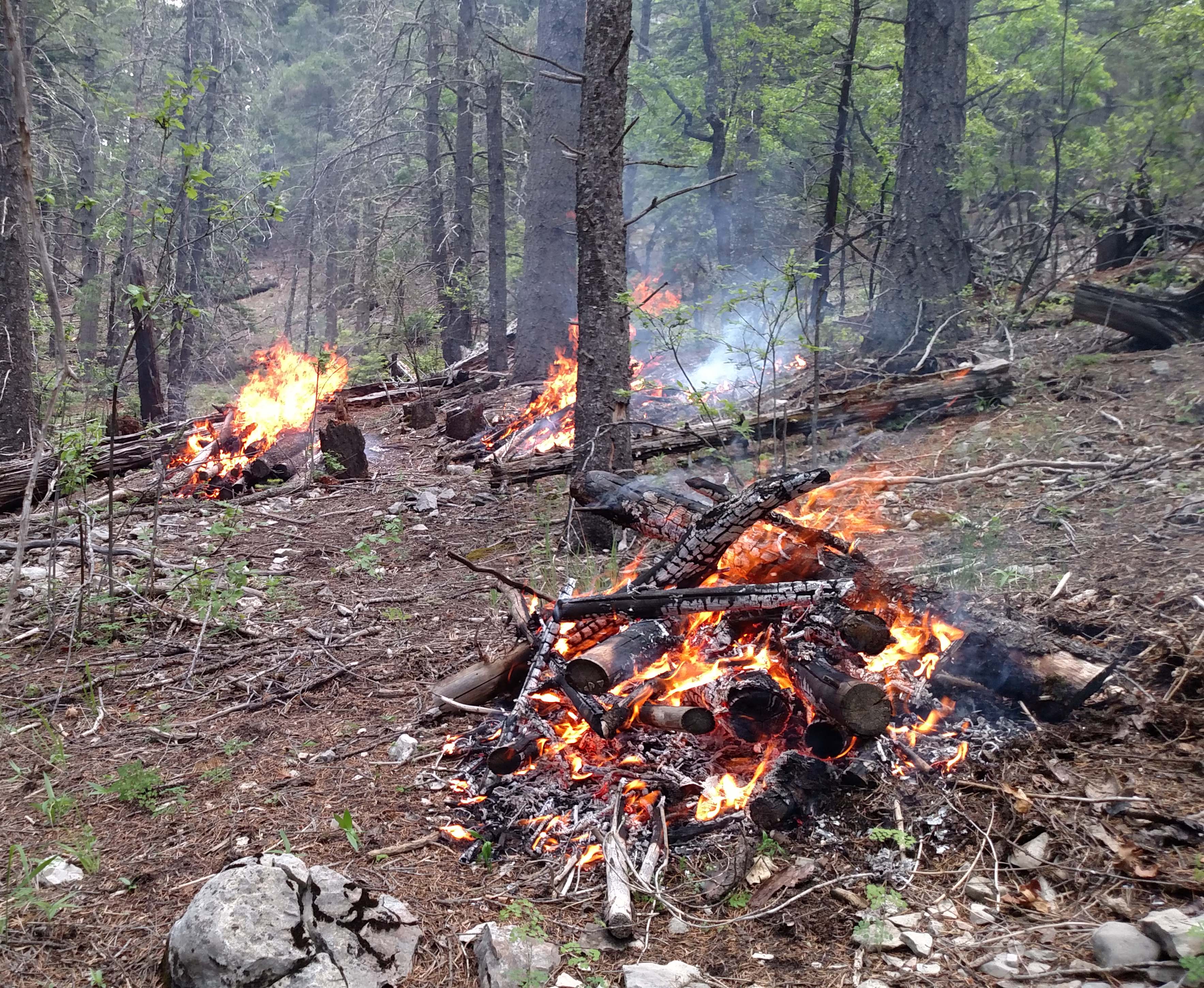
Cox Canyon – Rx Pile Burning – 06/26/16
UPDATE, June 26, 2016 10:45 am: Firefighters are resuming ignitions on the Cox Canyon Prescribed Fire project today. Recent moisture in the area resulted in favorable burning conditions for pile burning. Firefighters will ignite piles within the project area only when conditions are favorable as designated in the burn plan.
Sacramento Ranger District: Cox Canyon, 100 acres: piled slash, this unit is located along Highway 130 and is approximately 3 miles southeast of Cloudcroft.
Smoke will be visible from Cloudcroft and the surrounding area during ignitions.
During a wildfire or prescribed fire, if visibility becomes lower because of smoke, please visit the NM Department of Health’s smoke page: https://nmtracking.org/fire
UPDATE, June 12, 2016, 3:30 P.M.: Ignitions have ended for today on the Cox Canyon Prescribed Fire project. An additional 1.5 acres were burned today. With anticipated hotter and drier weather there will not be further burning in this project area this week. With more favorable conditions, burning may resume in the coming weeks or months.
UPDATE, June 12, 2016, 11:30 A.M.: Ignitions are underway again today (6/12/16) on the Cox Canyon Prescribed Fire project. Smoke will be visible during ignitions.
UPDATE, June 11, 2016, 3:30 P.M.: Ignitions are complete for today on the Cox Canyon Prescribed Fire project. Firefighters stopped burning around noon due to rain in the project area. They successfully burned approximately 1.5 acres of slash piles along Highway 130 near mile marker 5. Burning will continue tomorrow in the same area if weather conditions are favorable.
Slash piles burning in the Cox Canyon Prescribed Fire Project
UPDATE, June 11, 2016, 11:30 A.M.: Ignitions are underway on the Cox Canyon Prescribed Fire project. Firefighters are igniting piles of slash. Smoke will be visible during ignitions. They plan to cease ignitions early this afternoon and continue working on the project tomorrow.
During a wildfire or prescribed fire, if visibility becomes lower because of smoke, please visit the NM Department of Health’s smoke page: https://nmtracking.org/fire

Firefighters igniting slash piles on the Cox Canyon Prescribed Fire Project
UPDATE, June 10, 2016, 3:40 P.M.:
Ignition of the Cox Canyon prescribed fire is planned for Saturday, June 11, if conditions are favorable and may continue through early next week depending on the weather. The burn area consists of piles of slash located along Highway 130 approximately 3 miles southeast of Cloudcroft, NM. Approximately 100 acres are targeted for the prescribed burn which is intended to reduce fuel loads, minimize potential wildfire risks, protect communities, and create openings to improve wildlife habitat.
Public Information Officer: Loretta Benavidez, 575-430-5546, llbenavidez@fs.fed.us
ALAMOGORDO, CLOUDCROFT, NM, – For Immediate Release – With the arrival of moisture and lower fire danger, fire officials on the Lincoln National Forest are planning to resume prescribed burning operations on projects within the Sacramento Ranger District as a tool to promote forest health. Ignitions will take place during the months of June, July and August as weather conditions permit.
Sacramento Ranger District Prescribed Fire Projects:
- Cox Canyon, 100 acres: piled slash, this unit is located along Highway 130 and is approximately 3 miles southeast of Cloudcroft, NM.
- School, 12 acres: piled slash, this unit is located along Highway 130 and is approximately 1 mile south of Cloudcroft.
- Rice, 53 acres: piled slash, this unit is located along Highway 6563 (Sunspot Highway) and is approximately 10 miles south of Cloudcroft and one mile north of the Sunspot Observatory.
- Carissa, 243 acres: piled slash, this unit is located 11 miles southwest of Weed, NM and one half mile northwest of the Carissa Lookout Tower.
The prescribed burns involve the elimination of slash piles generated from thinning projects to reduce fuel loads, minimize potential wildfire risks, protect communities, and create openings to improve wildlife habitat. Ignition is dependent on favorable conditions, including fuel moisture levels, air quality and weather forecasts. Fire managers will monitor conditions closely to ensure public and firefighter safety, good smoke dispersal, and achievement of the desired effects identified in the burn plan.
During ignition operations, smoke may be visible from Cloudcroft, Weed, and surrounding areas. Smoke may settle into drainages and lower elevations at night, but is expected to dissipate by late-morning, as daytime temperatures increase. In the event that smoke is encountered on travel ways, motorists are advised to reduce travel speeds and turn lights on. During a wildfire or prescribed fire, if visibility becomes lower because of smoke, please visit the NM Department of Health’s smoke page: https://nmtracking.org/fire
Prescribed fire updates for the Lincoln National Forest will be posted on https://nmfireinfo.com/. The public and media are discouraged from entering into the areas where prescribed burning is taking place for their own safety and that of the firefighters. If there are questions, please contact Loretta Benavidez, Public Affairs Officer at 575-434-7290.
For more information about the Lincoln National Forest, visit www.fs.usda.gov/lincoln or follow us on Twitter: http://twitter.com/LincolnUSForest


Comments are closed.