
 June 8, 2020
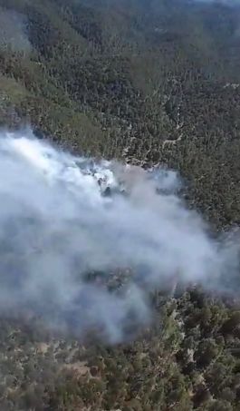
Smoke seen rising above the Tortolita Fire on 6/7/20
Incident Name – Tortolita Fire
Jurisdiction: State, Lincoln National Forest, Smokey Bear Ranger District
Size: 5 acres. (4.5 acres on private land. 0.5 acres on US Forest Service Land)
Containment: 50%
Cause: Unknown, Under Investigation
Date/Time Detected: 6/7/2020 3:45 pm
Location: Approximately 2 miles southwest of Nogal, NM. Between Church Mountain and Nogal Peak.
Lat/Long: 33°32’7.37″N, 105°43’57.71″W
Firefighting Resources: 2 engines plus support personnel, 2 patrol units, 1 smokejumper crew. Total personnel approximately 28.
Fuel Type: Pine, Pinyon-Juniper, Brush
Values at Risk: Private land, and at least 1 structure. Land improvements (ex. fences). 2 structures burned on 6/7/20.
Fire Update: The quick response of fire crews yesterday established control lines around the Tortolita Fire. Yesterday, two single-engine airtankers dropped four loads of water on the fire while ground crews built control lines. The lines held through the night and the fire remains at 5 acres in size and is 50 percent contained. Crews worked into the evening on the fire, which is burning 2 miles southwest of Nogal, New Mexico. Today, fire personnel will continue to extinguish hot spots. Temperatures today at the fire are expected to be in the 80s with winds gusting up to 25 miles per hour.
The wildfire is burning in an area with pine trees, pinyon-juniper, and brush. Two engines plus support personnel, two patrol units, and one smokejumper crew are currently assigned to the fire. Two structures burned yesterday and a third structure in the area remains.
Smoke may be visible from Nogal, NM, Highway 37, Nogal Canyon Road, and surrounding communities.
Please visit the NM Department of Health’s smoke page for information on protecting your health during fires and on smoky days: https://nmtracking.org/fire.
Another update can be expected tomorrow afternoon.
Tortolita Fire Map June 8 2020
PIO: Laura Rabon, 505-681-2837 laura.rabon@usda.gov


Comments are closed.