
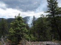
Location: 40 miles southeast of Reserve, New Mexico, near Snow Lake Start Date: June 7, 2017 Size: 11 acres Contained: 0% Cause: Lightning Vegetation: Standing snags, downed logs, and grass Resources: Incident Commander Type 4, 6 Firefighters The Teacher Fire is a lightning-caused fire that is being managed utilizing a confinement strategy. […]
Continue reading
Archive | NM Fire Info RSS feed for this section

Gila National Forest – Baca Fire, 6/8/2017
 June 9, 2017
  0 Comments
Location: Quemado Ranger District on the Gila National Forest 6 miles northeast of Quemado Lake Catron County, New Mexico Start Date: May 12, 2017 Size: 11,092 acres Cause: Lightning Vegetation: Ponderosa Pine, grass, and mixed conifer Smoke: Smoke is visible within the surrounding area of Quemado, Horse Springs and Pie Town, NM. Resources: 2 […]
Continue readingCarson National Forest Prepares to Utilize Bonita Fire for Multiple Resource Objectives
June 8, 2017 0 Comments
El Rito, NM – June 8, 2017 – For Immediate Release. Fire managers on the Carson National Forest have begun assessment and preparation to manage the lightning-caused Bonita Fire on the El Rito Ranger District to achieve multiple resource objectives on the landscape. Based on current and forecasted conditions, fire personnel could manage up to […]
Continue readingGila National Forest – Baca Fire June 7, 2017 @ 1700
June 8, 2017 0 Comments
Location: Quemado Ranger District on the Gila National Forest 6 miles northeast of Quemado Lake Catron County, New Mexico Start Date: May 12, 2017 Size: 11,092 acres Cause: Lightning Vegetation: Ponderosa Pine, grass, and mixed conifer Smoke: Smoke is visible within the surrounding area of Quemado, Horse Springs and Pie Town, NM. Resources: 2 […]
Continue reading Bonita Fire Continues to Burn
June 7, 2017 0 Comments
El Rito, NM, June 6th, 2017—For Immediate Release. Fire crews continue to monitor the Bonita Fire located on the El Rito Ranger District. The wildfire has increased in size to approximately 20 acres and is burning in a remote area. Fire behavior is low to moderate and is backing and creeping. Smoke-sensitive individuals and people […]
Continue readingGila National Forest – Corral Fire, June 6, 2017 @ 1700
June 6, 2017 0 Comments
June 6 PIO mapLocation: Wilderness Ranger District on the Gila National Forest in the Gila Wilderness Start Date: June 4, 2017 Size: 720 acres Cause: Lightning Containment: 0% Resources: Monitor status only Vegetation: Grass, pinon jumper and ponderosa pine stringers in the drainages Summary: The Corral Fire is burning on National Forest lands in […]
Continue readingGila National Forest – Baca Fire, June 6, 2017 @ 1700
June 6, 2017 0 Comments
Location: Quemado Ranger District on the Gila National Forest 6 miles northeast of Quemado Lake, Catron County, New Mexico Start Date: May 12, 2017 Size: 9,833 acres Cause: Lightning Vegetation: Ponderosa Pine, grass, and mixed conifer Smoke: Smoke is visible within the surrounding area of Quemado, Horse Springs and Pie Town, NM. Resources: 1 Wildland […]
Continue readingGila National Forest – Corral Fire
June 5, 2017 0 Comments
Location: Wilderness Ranger District on the Gila National Forest in the Gila Wilderness Start Date: June 4, 2017 Size: 100 acres Cause: Lightning Containment: 0% Resources: Monitor status only Vegetation: Grass, pinon jumper and ponderosa pine stringers in the drainages Summary: The Corral Fire is burning on National Forest lands in the Gila Wilderness. […]
Continue readingGila National Forest – Baca Fire June 5, 2017 @ 1300
June 5, 2017 0 Comments
Baca Fire, June 5, 2017 at 1300 Location: Quemado Ranger District on the Gila National Forest 6 miles northeast of Quemado Lake, Catron County, NM Start Date: May 12, 2017 Size: 8,800 acres Cause: Lightning Vegetation: Ponderosa Pine, grass, and mixed conifer Smoke: Smoke is visible within the surrounding area of Quemado, Horse Springs and […]
Continue readingGila National Forest – Baca Fire Update 6/4/2017
June 4, 2017 0 Comments
Location: Quemado Ranger District on the Gila National Forest 6 miles northeast of Quemado Lake Catron County, New Mexico Start Date: May 12, 2017 Size: 6,800 acres Cause: Lightning Containment:14% Vegetation: Ponderosa Pine, grass, and mixed conifer Smoke: Smoke may be visible within the surrounding area of Quemado, Pie Town, Horse Springs, and Datil, NM Resources: […]
Continue readingWildfire Mitigation Guide Available Free Online
June 2, 2017 0 Comments
The 2017 version of the Wildland Urban Interface Wildfire Mitigation Desk Reference Guide is now available online. This free guide provides basic background information on helpful programs and terminology for community members or fire departments who are seeking to enhance their community’s wildfire mitigation efforts. It is produced by the National Wildfire Coordinating Group, providing national […]
Continue readingLincoln National Forest – NEW FIRE reported on Sacramento Ranger District – 6/01/17 4:45 pm FIRST AND FINAL Fire Update
June 1, 2017 0 Comments
New Wildfire reported on the Sacramento Ranger District – BIRTHDAY FIRE: Fire Update – 6/01/17 – 4:45 pm – The Birthday Fire was reported at 3:02 pm on 6/1/17. It is located about 3 miles NW of Mayhill – (Lat 32 deg, 54 min, 56.91 sec x Long 105 deg, 31 min, 32.15 sec; Legal […]
Continue readingCoyote Ranger District Will Look for Windows to Continue Prescribed Burning
June 1, 2017 0 Comments
SANTA FE, NM – June 1, 2017 – For Immediate Release. Fire managers on the Coyote Ranger District, Santa Fe National Forest, are watching the weather and other factors to identify optimal windows to continue work on previously announced prescribed burns this spring. Yesterday, crews completed approximately 50 acres on the French Mesa unit. If […]
Continue readingLincoln National Forest – 5/31/17 1:15 pm Prescribed Fire Update – Lucas Well Pile Burn Project: Ignitions on hold
May 31, 2017 0 Comments
Smokey Bear Ranger District – Lucas Well Pile Burn project located 9 miles east of Ruidoso Prescribed Fire Update -5/31/17 1:15pm – Piles are burning well. Firefighters will not resume ignition operations until more humidity or precipitation is forecasted. Possibly will wait for onset of monsoons to resume ignitions. The primary objectives of this prescribed […]
Continue reading Are Potential Wildfire Dangers Lurking Around Your Home?
May 31, 2017 0 Comments
Wildfire season is nearly upon us but it doesn’t have to be a disaster. While New Mexico State Forestry and its interagency partners are well prepared for the season, the little things you do now can make a big difference. Our friends at PNM have some tips on how simply trimming your trees could help prevent […]
Continue readingCoyote Ranger District Plans Prescribed Burn This Week
May 30, 2017 0 Comments
SANTA FE, NM – May 30, 2017 – For Immediate Release. Fire managers on the Coyote Ranger District, Santa Fe National Forest, hope to take advantage of favorable conditions, including fuel moisture levels, air quality and forecasted weather, to conduct one of three previously announced prescribed burns as early as tomorrow, May 31. Fire managers […]
Continue readingLincoln National Forest – 5/30/17 10:30 am – FINAL Fire Update “Little John” fire on Sacramento Ranger District
May 30, 2017 0 Comments
Sacramento Ranger District – Little John Fire FINAL FIRE UPDATE: 5/30/17 10:30 am – The Little John Fire was 100% contained at 9:45 pm on May 29 at less than 3/10 of an acre. Light rain helped with the suppression efforts. Firefighters are returning to the fire today and possibly tomorrow to patrol the area. […]
Continue reading Final Hondito Wildfire Update 5/28/2017
May 28, 2017 0 Comments
Final Hondito Wildfire Update Location: Tres Piedras Ranger Station Hondito Canyon 4 miles southwest of Tres Piedras 2 miles North of Las Tablas Size: 7,020 acres* Size changed due to accurate GPS mapping Cause: Lightning Start Date: May 15, 2017 Taos, NM – For Immediate Release Hondito wildfire area will continue to be patrolled […]
Continue readingPrescribed Burn Planned for Luera Mountains on State Trust Land South of Datil, NM
May 27, 2017 0 Comments
Contact: Mark Meyers, Forester (505) 946-7082 The New Mexico State Land Office is preparing for a prescribed burn from May 30-June 10, 2017 on state trust land approximately 30 miles south of Datil, NM in the Luera Mountains. The intent of the burn is to reintroduce fire into the ecosystem. Returning fire to the area after […]
Continue reading Hondito Wildfire Update
May 26, 2017 0 Comments
Location: Tres Piedras Ranger Station Hondito Canyon 4 miles southwest of Tres Piedras 2 miles North of Las Tablas Size: 7,020 acres* Size changed due to accurate GPS mapping Cause: Lightning Start Date: May 15, 2017 Taos, NM – For Immediate Release- Increasing temperatures and accompanied winds are in the extended forecast, which […]
Continue reading


