
Wilderness District fire managers estimate the McKenna Fire has grown to 1,900 acres since it was first reported Friday, May 7 in the Gila Wilderness. The fire is located about eight miles west of the Gila Cliff Dwellings National Monument. The McKenna Fire is being managed for multiple objectives that will help reduce exposure to […]
Continue reading
Archive | NM Fire Info RSS feed for this section
Valles Caldera National Preserve Plans Prescribed Burn For Valle Grande
 May 9, 2016
  0 Comments
The Valles Caldera National Preserve is planning to implement a prescribed burn project on the preserve that will begin as soon as Wednesday, May 11 and be completed within two to three days. The prescribed burn will target up to 1,471 acres of grass in the Valle Grande, adjacent to NM Highway 4 between mile […]
Continue reading Prescribed Burn Planned on the Santa Fe National Forest Española Ranger District
May 9, 2016 0 Comments
Santa Fe, NM – May 9, 2016 – For Immediate Release. Fire managers on the Santa Fe National Forest hope to take advantage of current conditions to conduct the previously announced Mesitas prescribed burn on the Española Ranger District this week. The 1,700-acre treatment area is located approximately six miles southwest of Abiquiu, 15 miles […]
Continue readingWildfire spreads at Guadalupe Mountains National Park
May 9, 2016 0 Comments
Salt Flat, Texas – The Coyote Peak wildfire burning in Guadalupe Mountains National Park reported Sunday, May 8 has grown to over 4500 acres and has advanced into New Mexico and is now on to State and private lands. No buildings, dwellings or structures have been affected by the fire. High winds continue to push […]
Continue readingMay 8 Coyote Fire PM Update
May 8, 2016 0 Comments
A lightning ignited fire was discovered near Coyote Peak in the northwest corner of Guadalupe Mountains National Park at 1:30 p.m. on Saturday, May 7. As of Sunday afternoon, May 8, the Coyote Peak fire is estimated to have burned approximately 3000 acres. High winds are pushing the fire north and east across the park […]
Continue readingCoyote Fire information is available on Inciweb.
May 8, 2016 0 Comments
Updates on the Coyote Fire, burning in Guadalupe Mountains National Park, near the NM/TX border, is available at http://inciweb.nwcg.gov/incident/4719/.
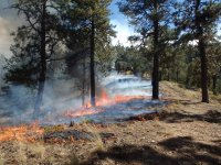
Continue readingGila National Forest – Lightning sparks McKenna Fire in Gila Wilderness
May 7, 2016 0 Comments
The Bearwallow Fire Lookout reported the McKenna Fire Friday, May 6. Today’s flight shows the fire has grown to 400 acres. It’s located in the Gila Wilderness approximately 10 miles west of the Gila Cliff Dwellings National Monument. The fire is being managed for multiple resource objectives. http://tinyurl.com/jebmf93
Continue readingFinal Update: Horseshoe Fire on Santa Fe National Forest 100% Contained
May 6, 2016 0 Comments
Final update 8:30 p.m. Location: Jemez Ranger District of the Santa Fe National Forest West of the community of La Cueva and east of Forest Road 376 Latitude and Longitude: 35°52’30″N 106°39’18″W Start Date: May 6, 2016 Size: Approximately 2.3 total acres Percent Contained: 100% as of 7:30 p.m. Cause: Downed power line Growth Potential: Low […]
Continue readingHorseshoe Fire on Santa Fe National Forest
May 6, 2016 0 Comments
May 6, 2016; 6:00 p.m. Location: Jemez Ranger District of the Santa Fe National Forest Near Fenton Ranch and the Rio Cebolla (additional information on location is expected soon) Start Date: May 6, 2016 Size: Approximately 1.3 acres at 6 p.m. Percent Contained: 0% Cause: Downed power line Growth Potential: Moderate Vegetation: Ponderosa pine, pine […]
Continue readingPrescribed Burn Planned for Buckman, West of Santa Fe, NM
May 5, 2016 0 Comments
The Bureau of Land Management (BLM) Taos Field Office Fire Crew will conduct a prescribed burn at Buckman, west of Santa Fe, New Mexico, during the month of May, weather permitting. The objectives of the burn are to remove slash (limbs and branches) created as part of a riparian restoration project, reduce wildfire risk, and […]
Continue readingLincoln National Forest – Guadalupe Ranger District – 5/1/16 – 3:45 PM FINAL UPDATE ON GOAT Rx
May 1, 2016 0 Comments
5/1/2016 – 3:45 PM PRESCRIBED FIRE UPDATE: Low level cloud cover over the Goat Rx has assisted firefighters in mop-up efforts. There are very few smokes visible at this time. Firefighters will continue to mop-up, monitor conditions, and patrol the area for the next few days. This will be the FINAL UPDATE unless there is a significant […]
Continue readingLincoln National Forest – FIRE UPDATE – 4/27/16 11:55 AM – Inspiration Fire is 100% Contained!
April 27, 2016 0 Comments
Inspiration Fire Jurisdiction: Lincoln National Forest, Smokey Bear Ranger District Date/Time Detected: 4/25/16 8:34 pm Location: Approximately 1 mile southeast of Ruidoso Downs, NM Lat/Long: 33 deg, 19 min, 17.8 sec X 105 105, 34 min, 50.53 min Legal Description: T11S, R14E, Sec 28 Firefighting Resources: The US Forest Service hotshot crew will transfer command back […]
Continue readingLincoln National Forest – FIRE UPDATE 4/26/16 – 11:00 am Pendleton Fire 100% Contained at 1 acre!
April 26, 2016 0 Comments
“Pendleton Fire” Jurisdiction: Lincoln National Forest, Sacramento Ranger District Date/Time Detected: 4/25/16 1:50 pm Location: Approximately 4 miles southwest of Weed, NM and 15 miles southeast of Cloudcroft, NM Lat/Long: 32 deg, 46 min, 40.26 sec X 105 deg, 34 min, 59.51 min Legal Description: T18S, R13E, Sec 2 Firefighting Resources: At this time, one […]
Continue readingCameron Creek Rx Fire – Closure Order Lifted
April 25, 2016 0 Comments
The area closure for the Cameron Creek Rx Fire will be lifted Tuesday, April 26. http://tinyurl.com/jedbt43
Continue readingLincoln National Forest – FINAL FIRE UPDATE: 4/23/16 11:00 am – Gilson Canyon Fire
April 22, 2016 0 Comments
Fire Update: 4/22/16 11:00 am “Gilson Canyon Fire” Jurisdiction: Lincoln National Forest, Guadalupe Ranger District Date/Time Detected: 4/20/16 3:05 pm Location: Approximately 6 miles northeast of Queen, NM and east of Sitting Bull Falls Recreation Area Lat/Long: 32 deg, 14 min, 32.31 sec X 104 deg, 41’ 26.89 min Legal Description: T24S, R22E, Sec 3 Firefighting […]
Continue readingGila National Forest – new fire
April 21, 2016 0 Comments
Resources responded to the Rael Fire on the Reserve Ranger District Thursday afternoon. Forward progress has been stopped. The Rael Fire is estimated at 64 acres, located 18 miles southeast of Apache Creek and south of Highway 12.
Continue readingGila National Forest – Cameron Creek Rx Fire update
April 21, 2016 0 Comments
Fire managers completed 200 acres Thursday bringing the total to 1,100 acres completed. No ignitions are planned for Friday. Crews will monitor and patrol the project.
Continue readingBLM Plans Prescribed Burn in Socorro County
April 21, 2016 0 Comments
BLM Plans Prescribed Burn in Socorro County Socorro, NM – The Bureau of Land Management’s Socorro Field Office is planning a prescribed burn of up to 100 acres in Socorro County between late April and the end of May, weather permitting. The burn includes the 100 acre Wolf Wells Prescribed Burn located 12 miles […]
Continue readingPrescribed Burn Planned for Centennial Bombing Range
April 21, 2016 0 Comments
Prescribed Burn Planned for Centennial Bombing Range Las Cruces, NM – On April 27, the Bureau of Land Management (BLM) is planning a prescribed burn in the Centennial Bombing Range on the McGregor Range, weather permitting. Centennial is approximately 20 miles northeast of Oro Grande, New Mexico, in Otero County. An anticipated 500 acres […]
Continue readingGila National Forest – Cameron Creek Rx Fire update
April 20, 2016 0 Comments
Fire managers have completed approximately 900 acres on the Cameron Creek Rx Fire, six miles north and east of Silver City. Smoke is drifting east of the project area. Operations will continue Thursday.
Continue reading


