
Additional Evacuations Ordered Progress Made on the West and Northeast Sides of the Black Fire Daily Update 5/28/2022 Acres: 212,118 acres Location: 31 miles NW of Truth or Consequences Containment: 18% Personnel: 806 Start Date: Friday, May 13, 2022 Cause: Human-caused, under investigation Fuels: Timber and tall grass Structures Lost: 2 Overview: On the evacuation map, Area 11 that was in […]
Continue readingIncendios de Hermits Peak y Calf Canyon 28 de mayo de 2022, Actualización diaria
 May 28, 2022
  0 Comments
Acres: 314,228 | Contención: 48% | Total del personal: 2,950 Fecha de inicio: Hermits Peak: 6 de abril 2022; Calf Canyon: 19 de abril 2022 | Causa: Hermits Peak: Fuegos salpicados por quemaduras prescritas; Calf Canyon: Restos de un incendio prescrito | Ubicación: Cerca de Gallinas Canyon | Combustibles: Mezcla de coníferas, pino ponderosa, arbustos […]
Continue readingHermits Peak and Calf Canyon Fires May 28, 2022, Daily Update
May 28, 2022 0 Comments
Acres: 314,228 | Containment: 48% | Total personnel: 2,950Start Date: Hermits Peak: April 6, 2022; Calf Canyon: April 19, 2022 | Cause: Hermits Peak: Spot fires from prescribed burn; Calf Canyon: Holdover fire from prescribed pile burn | Location: Located near Gallinas Canyon | Fuels: Heavy mixed conifer, ponderosa pine, brush, and grass Highlights: A […]
Continue readingCerro Pelado Fire
May 28, 2022 0 Comments
Daily Update Saturday, May 28, 2022 Information Phone Line: 505-312-4593Email: 2022.CerroPelado@firenet.gov InciWeb: https://inciweb.nwcg.gov/incident/8075/ Facebook: https:/facebook.com/2022.Cerropeladofire Twitter: https:/twitter.com/SantafeNF INCIDENT STATISTICS: Current Size: 45,605 AcresCurrent Containment: 95%Start Date: April 22, 2022 Cause: UnknownTotal personnel: 463 WEATHER AND FIRE BEHAVIOR Temperatures will continue to increase over the fire area with relative humidity remaining in the single digits. Fire activity has […]
Continue readingCerro Pelado Post-Fire BAER SBS Map Released, May 27, 2022
May 27, 2022 0 Comments
May 27, 2022 BAER Information: (707) 853-4243 CERRO PELADO POST-FIRE BAER SOIL BURN SEVERITY MAP RELEASED SANTA FE, NM – May 27, 2022 – Burned Area Emergency Response (BAER) specialists from the USDA Forest Service and the US Department of Interior assessment teams have completed data gathering and analysis for the Cerro Pelado Fire. The […]
Continue reading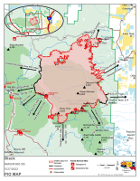
Black Fire Daily Update: 5/27/22
May 27, 2022 0 Comments
Firefighters working day and night to contain the Black FireCritical fire weather anticipated through the weekend Acres: 191,459 acres Location: 31 miles NW of Truth or Consequences Containment: 13% Personnel: 784 Start Date: Friday, May 13, 2022 Cause: Human-caused, under investigation Fuels: Timber and tall grass Structures Lost: 2 Overview: The Black Fire has over […]
Continue readingHermits Peak and Calf Canyon Fires, May 27, 2022
May 27, 2022 0 Comments
27 de mayo 2022, actualización diaria, 08:00AM Acres: 312,230 | Contención: 47% | Total de personal: 3,009 Fecha de inicio: Hermits Peak: 6 de abril 2022; Calf Canyon: 19 de abril 2022 | Causa: Hermits Peak: Fuegos salpicados por quemaduras prescritas; Calf Canyon: Bajo investigación | Ubicación: Cerca de Gallinas Canyon Combustibles: Mezcla de coníferas, […]
Continue readingFire Investigators Determine Cause of Calf Canyon Fire
May 27, 2022 0 Comments
SANTA FE, NM – May 27, 2022 – Forest Service fire investigators have determined that the Calf Canyon Fire on the Pecos/Las Vegas Ranger District of the Santa Fe National Forest (SFNF) was caused by a pile burn holdover from January that remained dormant under the surface through three winter snow events before reemerging in […]
Continue readingCerro Pelado Fire, May 27, 2022
May 27, 2022 0 Comments
Daily Update – Friday, May 27, 2022 Information Phone Line: 505-312-4593 | Email: 2022.CerroPelado@firenet.gov InciWeb: inciweb.nwcg.gov/incident/8075/ | Facebook: http://www.facebook.com/2022.CerroPeladoFire Twitter: twitter.com/SantafeNF INCIDENT STATISTICS: Current Size: 45,605 Acres | Current Containment: 92% |Start Date: April 22, 2022 Cause: Unknown Resources: 12 Type 2 hand crews, 18 engines, 1 bulldozer, 9 water tenders, 3 ambulances, 2 helicopters WEATHER AND FIRE BEHAVIOR Temperatures […]
Continue readingWildfire Preparedness is Year-Round: Know Before You Go!
May 27, 2022 0 Comments
As we gather to honor our fallen heroes this Memorial Day weekend and into the summer, support firefighters and protect your community by preventing any additional wildfire ignitions. We are experiencing historic levels of fire danger and restrictions and closures are in place in many areas across the state to prevent wildfires– in fact, many […]
Continue readingBLM strengthens fire restrictions and suspends firewood sales for Albuquerque District’s Rio Puerco and Socorro Field Offices
May 27, 2022 0 Comments
Due to increased fire danger and prolonged drought, the BLM’s Albuquerque District has updated Fire Prevention Order # NMA00000-22-01 and suspended sale of all fuelwood permits. The updated fire prevention order stipulates that cutting or grinding metal, or using a welder, either arc or gas, or operating acetylene or other torch with open flame (hot work) […]
Continue reading
Bear Trap Fire update May 27, 2022
May 27, 2022 0 Comments
Acres: 38,091 acres Containment: 41% Cause: Undetermined Total Personnel: 428 Start Date: May 1, 2022 Location: San Mateo Mountains, Magdalena Ranger District, Socorro County, NM Fuels: Pine, Pinyon-Juniper and Grass Highlights: Thursday was a solid day on the Bear Trap Fire as crews patrolled fire containment lines and conducted mop up operations along the southern […]
Continue readingHermits Peak and Calf Canyon Fires, May 27, 2022
May 27, 2022 0 Comments
May 27, 2022, Daily Update, 08:00AM Acres: 312,230 | Containment: 47% | Total personnel: 3,009 Start Date: Hermits Peak: April 6, 2022; Calf Canyon: April 19, 2022 | Cause: Hermits Peak: Spot fires from prescribed burn; Calf Canyon: Under investigation | Location: Located near Gallinas Canyon Fuels: Heavy mixed conifer, ponderosa pine, brush, and grass […]
Continue readingBlack Fire Daily Update: 5/26/22
May 26, 2022 0 Comments
Acres: 179,539 acres Containment: 13% Location: 31 miles NW of Truth or Consequences Personnel: 777 Structures Lost: 2 Fuels: Timber and tall grass Cause: Human-caused, under investigation Overview: Personnel conducted firing operations along Turkey Creek Road to keep the fire south of State Highway 59 and west of State Highway 52. The rugged nature, inaccessible […]
Continue readingCerro Pelado Fire Daily Update Thursday, May 26, 2022
May 26, 2022 0 Comments
INCIDENT STATISTICS: Current Size: 45,605 Acres Current Containment: 92% Start Date: April 22, 2022 Cause: Unknown Total personnel: 434 WEATHER AND FIRE BEHAVIOR There will be warmer weather over the fire area today with sunny skies in the morning. There is zero percent chance of precipitation, and the maximum temperature will reach into the low […]
Continue readingCarlsbad Caverns National Park Implements Additional Fire Restrictions Due to Extreme Fire Danger
May 26, 2022 0 Comments
FOR IMMEDIATE RELEASE May 24, 2022 Contact: Laura Steele, Acting Chief Ranger, 575-236-1426, laura_steele@nps.gov CARLSBAD, New Mexico — Extreme fire danger continues to affect Carlsbad Caverns National Park. As a result, effective May 25, the following additional restrictions are in effect: Closure of Carlsbad Caverns Wilderness Area and all backcountry areas to day use. This includes access to all permit […]
Continue readingAmended Stage II Fire Restrictions for Gila National Forest – Effective May 24, 2022
May 26, 2022 0 Comments
Gila National Forest Amends Stage II Fire Restriction Order Silver City, NM, May 24—With the Gila National Forest experiencing a very active fire season during unprecedented drought conditions, forest leadership has taken steps to decrease the chances of additional human-caused wildfires. The forest has amended the stage two fire restriction order, implemented initially on May […]
Continue readingHermits Peak and Calf Canyon Fires, May 26, 2022
May 26, 2022 0 Comments
May 26, 2022, Daily Update, 08:00AM Acres: 312,057| Containment: 46% | Total personnel: 3,091 Start Date: Hermits Peak: April 6, 2022; Calf Canyon: April 19, 2022 | Cause: Hermits Peak: Spot fires from prescribed burn; Calf Canyon: Under investigation | Location: Located near Gallinas Canyon Fuels: Heavy mixed conifer, ponderosa pine, brush, and grass Highlights: […]
Continue readingBear Trap Fire Update – May 26, 2022
May 26, 2022 0 Comments
Acres: 33,196 acres Containment: 28% Cause: Undetermined Total Personnel: 558 Start Date: May 1, 2022 Location: San Mateo Mountains, Magdalena Ranger District, Socorro County, NM Fuels: Pine, Pinyon-Juniper and Grass Highlights: Continued windy conditions Wednesday allowed for a good test of the fire perimeter. All containment lines held, including the area that was reestablished Tuesday […]
Continue readingBlack Fire Evacuation Update – 8 p.m. May 25, 2022
May 25, 2022 0 Comments
Additional evacuations issued on the Black Fire Afternoon Update 5/25/2022 8:00 pm Announcement: Effective immediately, the Black Fire is implementing additional evacuations. Evacuations: In coordination with Grant County Sheriff’s Office, the evacuation status for the following areas have changed: Area 8: The area east of Forest Road 150 is now in a GO evacuation. The area […]
Continue reading


