
Start Date / Time: May 20, 2024, approximately 3:45 p.m. Cause: Unknown, Under Investigation Size: 96 acres Location: 4 miles east of Cloudcroft Resources: Firefighters from US Forest Service, Volunteer Fire Departments, BLM, State, 2-dozer, 1 helicopter, additional aviation resources (as needed) Types of vegetation in the area (aka fuels): Mixed Conifer Containment: 12% Strategy: Full Suppression Road […]
Continue reading
Tag Archives: Lincoln National Forest


Moser Fire Evening Update, May 21, 2024
 May 20, 2024
  0 Comments
Start Date / Time: May 20, 2024, approximately 3:45 p.m. Cause: Unknown, Under Investigation Size: 96 acres Location: 4 miles east of Cloudcroft Resources: Firefighters from US Forest Service, Volunteer Fire Departments, BLM, State, 2-dozer, 1 helicopter, additional aviation resources (as needed) Types of vegetation in the area (aka fuels): Mixed Conifer Containment: 12% Strategy: Full Suppression Road […]
Continue readingApple Tree Fire, July 22 Update
July 22, 2023 0 Comments
Start Date / Time: July 18, 2023, 9:00 pm Cause: Lightning Size: 100 acres Containment: 2% Location: East of Sacramento Lookout Tower, 6 mi. north of the community of Timberon, 3.5 miles southeast of Sunspot, NM. Fire Strategy: Confine and contain Resources: 1 type-1 crew, 1 type-2 crew, 1 fuels crew, 1 dozer, 2 engines, 1 module, additional […]
Continue readingBird Fire Final Update: 6/12/22 10:45am
June 12, 2022 0 Comments
Jurisdiction: Lincoln National Forest, Sacramento Ranger District Size: 2 acres Cause: Lightning Date/Time Detected: June 11, 2022, 4:30 pm Location: Near Bird Spring in Dark Canyon between Highway 130 and Rd 233 (aka Dark Canyon Rd.) Google Map of the fire’s location Firefighting Resources: 2 Engines, 2 hotshot crews, 1 bulldozer Fuel Type: Dense dead and down […]
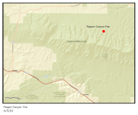
Continue reading Peppin Canyon Fire Update: 6/11/22, 8pm
June 11, 2022 0 Comments
Jurisdiction: Lincoln National Forest, Smokey Bear Ranger District Size: 2.5 acres Cause: Lightning Location: North side of the Capitan Wilderness.Map of the fire’s location: https://maps.nwcg.gov/sa/#/%3F/%3F/33.5984/-105.3212/12 Firefighting Resources: 1 wildland fire module, 1 engine, 1 repel crew, 1 type-3 helicopter. 2 single-engine airtankers. Fuel Type: The fire is in a burn scar and is burning in brush and dead and down […]
Continue readingNew Start: Bird Fire, Lincoln National Forest
June 11, 2022 0 Comments
Incident Name – Bird Fire Jurisdiction: Lincoln National Forest, Sacramento Ranger District Size: 2 acres Cause: Lightning Date/Time Detected: June 11, 2022, 4:30 pm Location: Near Bird Spring in Dark Canyon between Highway 130 and Rd 233 (aka Dark Canyon Rd.) Google Map of the fire’s location Firefighting Resources: 2 Engines, 1 hotshot crew. Fuel Type: Dense […]
Continue readingNew Start-Peppin Canyon Fire, Lincoln National Forest
June 11, 2022 0 Comments
Incident Name – Peppin Canyon Fire Jurisdiction: Lincoln National Forest, Smokey Bear Ranger District Size: 2 acres Date/Time Detected: June 11, 2022, 3:00 pm Cause: Lightning Location: North side of the Capitan Wilderness Firefighting Resources: County and Forest Service firefighting resources. Type 3 helicopter. Air Attack. Fuel Type: The fire is in a burn scar and is […]
Continue readingLincoln National Forest in Stage 2 Fire Restrictions
April 28, 2022 0 Comments
The Lincoln National Forest joins other forest and parks in New Mexico who are implementing strict fire restrictions among a flurry of wildfires across the state. The Lincoln National Forest is entering Stage 2 fire restrictions just a week after going into Stage 1 restrictions. Under stage 2 fire restrictions the following is prohibited All […]
Continue readingNogal Fire Update, April 17, 10 AM
April 17, 2022 0 Comments
Nogal Canyon Fire – Sunday, April 17, 2022 Daily Update Acres: 433Cause: Downed power linesContainment: 42%Start Date: April 12, 2022Personnel : 127Location/Origin: Nogal Canyon, west of CapitanFuels: Ponderosa pine, pinon and juniper, grassesStructures burned: 6 primary, 8 outbuildings Highlights: Firefighters have successfully contained 42% of the fire with a hand-built line along the ridge on […]
Continue readingMcBride Fire Update: April 17, 9:02 AM
April 17, 2022 0 Comments
McBride Fire – Sunday, April 17, 2022 Daily Update Acres: 6,159Cause: Under investigationContainment: 56%Start Date: April 12, 2022Location: Gavilan Canyon within the Village of RuidosoFuels: Timber, brush, grassesStructures burned: 207 primary structures, multipleoutbuildingsPersonnel: 381 Fatalities: 2 citizens Highlights: Yesterday, significant progress was made towards securing containment of the McBride fire. Due to a focused effort […]
Continue readingMcBride Fire Update: April 16, 10:20 AM
April 16, 2022 0 Comments
McBride Fire – April 16, 2022 Daily Update Acres: 6,195Cause: Under investigationContainment: 0%Start Date: April 12, 2022Location: Gavilan Canyon within the Village of RuidosoFuels: Timber, brush, grassesStructures burned: 207 primary structures, multipleoutbuildingsPersonnel: 299 Fatalities: 2 citizens Highlights: A Virtual Public Meeting will be held tonight at 6pm on Facebook. Questions can be submitted in advance […]
Continue readingNogal Fire Update: April 15, 10:10 AM
April 15, 2022 0 Comments
Nogal Fire April 15, 2022 Morning Update A Public meeting will be held on Facebook Saturday Evening at 6:00 PM for the Nogal and McBride Fires Acres: 427 Cause: Downed power lines Containment: 4% Start Date: April 12, 2022 Location/Origin: Nogal Canyon, west of Capitan Fuels: Ponderosa pine, pinon and juniper, grass Structures burned: 6 […]
Continue reading McBride Fire Update: April 15, 9:26 AM
April 15, 2022 0 Comments
McBride Fire – April 15, 2022 Morning Update A Public Meeting will be held on Facebook Saturday evening at 6:00 PM Acres: 6,167 Cause: Under investigation Containment: 0% Start Date: April 12, 2022 Location: Gavilan Canyon within Ruidoso Fuels: Timber, brush, dry grasses Structures burned: 207 primary structures, multiple outbuildings Fatalities: 2 Highlights: Yesterday favorable […]
Continue readingNogal Fire Update, April 14, 12 PM
April 14, 2022 0 Comments
Nogal Fire April 14, 2022 Daily Update Acres: 345 Cause: Downed power lines Containment: 4% Start Date: April 12, 2022 Location/Origin: Nogal Canyon Fuels: Ponderosa, pinon and juniper, dry grasses Structures Burned: 6 primary, 8 outbuildings Highlights: Yesterday fire activity decreased significantly on the Nogal Fire. Less severe wind conditions are enabling crews to […]
Continue readingMcBride Fire Update: April 14, 11:44 AM
April 14, 2022 0 Comments
McBride Fire Daily Update – April 14, 2022 Acres: 5,736 acres Cause: Under investigation Containment: 0% Start Date: April 12,2022 Location: Gavilan Canyon within the Village of Ruidoso Fuels: Timber, brush, dry grasses Structures burned: 207 primary structures, multiple outbuildings Fatalities: 2 Highlights: Yesterday firefighters continued to focus on structural point protection in the […]
Continue readingNogal Canyon Fire Update: April 13, 10am
April 13, 2022 0 Comments
Firefighters Work to Contain Nogal Canyon Fire Location: Nogal Canyon Start date: April 13, 2022 Cause: Downed Powerlines Size: 400 acres Containment: 0% Resources: Lincoln County and US Forest Service Vegetation: Pinon/Juniper/Ponderosa Pine Capitan, NM April 13, 2022, 10:00 am. Yesterday, winds of 45 mph, with gusts from 50-90 mph, were responsible for downed power […]
Continue reading16 Springs Prescribe Fire on the Sacramento Ranger District of the Lincoln National Forest Scheduled for Spring 2022
March 22, 2022 0 Comments
Fire officials on the Sacramento Ranger District in Cloudcroft, NM, plan to implement prescribed fire operations on the 16 Springs Prescribed Fire project beginning in March and carrying into April of 2022. The 16 Springs Prescribed Fire is targeting 564 acres and is located on federal land five miles north of Mayhill, NM. The project […]
Continue reading Prescribed Burns Scheduled on the Lincoln National Forest, Smokey Bear Ranger District
February 7, 2022 0 Comments
Prescribed Burns West of Ruidoso Ruidoso, NM – Feb. 7, 2022—The Smokey Bear Ranger District on the Lincoln National Forest is planning to conduct prescribed burns in the Grindstone and Perk Canyon areas west of Ruidoso as early as tomorrow, Tuesday, February 8. Prescribed burning will continue throughout winter and spring as conditions allow. Crews […]
Continue readingOtero County Slash Pit Burn Scheduled on Monday
January 7, 2022 0 Comments
Cloudcroft, NM – January 7, 2022– The Otero County Slash Pit located northeast of Cloudcroft, NM on Highway 244 is scheduled to be burned on Monday, January 10, 2022. Smoke will be visible from Cloudcroft and along nearby roadways including Hwy 244 and Hwy 82. Please use extra caution when driving in smokey conditions. Guidelines […]
Continue readingPOSTPONED: Lincoln National Forest, Prescribed Burn Planned in the 16 Springs Area, Sacramento Ranger District
November 30, 2021 0 Comments
UPDATE: 11/30/2021 – The 16 Springs Prescribed Burn has been postponed. CLOUDCROFT, NM – 11/29/20: The Sacramento Ranger District plans to begin prescribed burning in the 16 Springs area approximately 3 miles north of Mayhill, NM beginning the last week in November and continuing throughout the winter and spring as conditions allow. Smoke from the […]
Continue reading


