
This will be the last fire update for the Camp Fire unless there is a significant change. Acres: 877 Cause: Under investigation Containment: 76% Total personnel: 69 Structures Damaged: 5Start Date: May 25, 2025 Location: Fort Stanton – Snowy River Cave National Conservation Area Fire Update Command of the Camp Fire, which started on Sunday, […]
Continue reading
Archive by Author


Camp Fire Update 5/28/25: Rob Jaggers Campground and Fort Stanton Reopen Tomorrow
 May 28, 2025
  0 Comments
Acres: 877 Cause: Under investigation Containment: 70% Total personnel: 120 Structures Damaged: 4Start Date: May 25, 2025 Location: Fort Stanton – Snowy River Cave National Conservation Area Fire Update Containment continues to increase as crews make progress on securing the fire line. The fire has not spread for several days however, after more accurate GIS […]
Continue reading Camp Fire Evening Update 5/27/25: Containment Jumps to 47% on the Camp Fire
May 27, 2025 0 Comments
Acres 720 Cause: Under investigation Containment: 47% Total personnel: 147 Structures Damaged: 4 Start Date: Sunday, May 25, 2025Location: Fort Stanton – Snowy River Cave National Conservation Area Fire Update Crews made significant progress today securing large portions of the fire line on the north and south sides of the fire. Fire containment increased to […]
Continue readingCamp Fire Morning Update 05/27/25: Crews Secure Fire Lines on the Camp Fire
May 27, 2025 0 Comments
Acres: 720 Cause: Under investigation Containment: 4%Total personnel: 147 Structures Damaged: 4Start Date: May 25, 2025 Location: Black Jack Pershing Rd. and Bonito Loop, Fort Stanton, NM Fuels: Pinon-juniper, grass Fire Update Fire lines continue to hold. There was no fire spread overnight. Today fire crews will continue to secure the perimeter of the fire […]
Continue reading Camp Fire Update 5/26/25: Work Continues on the Camp Fire Near Fort Stanton
May 26, 2025 0 Comments
Acres: 720 Cause: Under investigation Containment: 4% Total personnel: 96 Structures Damaged: 4Start Date: May 25, 2025Location: Black Jack Pershing Rd. and Bonito Loop, Fort Stanton, NMFuels: Pinon-juniper, grass Fire Update Crews were able to better map the fire perimeter today and the new total acreage is 720. Most of the burned acres occurred yesterday […]
Continue readingCamp Fire Update 5/26/25: Progress Made on the Camp Fire
May 26, 2025 0 Comments
Acres: 350 Cause: Under investigation Containment: 0% but will likely increase as the day progresses Total personnel for all incidents: 78Start Date: May 25, 2025 Location: Black Jack Pershing Rd. and Bonito Loop, Fort Stanton, NM Fuels: Pinon-juniper, grass Fire Update: Yesterday firefighters and air support responded to the Camp Fire in the Ft. Stanton […]
Continue readingMoser Fire Morning Update, May 21, 2024
May 21, 2024 0 Comments
Start Date / Time: May 20, 2024, approximately 3:45 p.m. Cause: Unknown, Under Investigation Size: 96 acres Location: 4 miles east of Cloudcroft Resources: Firefighters from US Forest Service, Volunteer Fire Departments, BLM, State, 2-dozer, 1 helicopter, additional aviation resources (as needed) Types of vegetation in the area (aka fuels): Mixed Conifer Containment: 12% Strategy: Full Suppression Road […]
Continue reading Moser Fire Evening Update, May 21, 2024
May 20, 2024 0 Comments
Start Date / Time: May 20, 2024, approximately 3:45 p.m. Cause: Unknown, Under Investigation Size: 96 acres Location: 4 miles east of Cloudcroft Resources: Firefighters from US Forest Service, Volunteer Fire Departments, BLM, State, 2-dozer, 1 helicopter, additional aviation resources (as needed) Types of vegetation in the area (aka fuels): Mixed Conifer Containment: 12% Strategy: Full Suppression Road […]
Continue reading Apple Tree Fire, June 21 Update
July 21, 2023 0 Comments
Start Date / Time: July 18, 2023, 9:00 pm Cause: Lightning Size: 62 acres Containment: 2% Location: East of Sacramento Lookout Tower, 6 mi. north of the community of Timberon, 3.5 miles southeast of Sunspot, NM. Fire Strategy: Confine and contain Resources: 1 type-1 crew, 1 type-2 crew, 1 fuels crew, 1 dozer, 2 engines, 1 module, additional […]
Continue readingLincoln National Forest New Fire Start: Apple Tree Fire July 19 Update
July 19, 2023 0 Comments
Start Date / Time: July 18, 2023, 9:00 pm Cause: Lightning Size: 9 acres Location: East of Sacramento Lookout Tower, 6 mi. north of the community of Timberon, 3.5 miles southeast of Sunspot, NM. Resources: 2 engines; 2 modules; 1 dozer; additional support personnel. Total personnel: 28 Types of vegetation in the area (aka fuels): Mixed conifer, locust and […]
Continue readingPeppin Canyon Fire Final Update: 6/13/22, 9:15 am
June 13, 2022 0 Comments
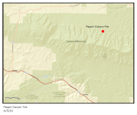
Size: 2.5 acres Cause: Lightning Date/Time Detected: June 11, 2022, 3:00 pm Location: North side of the Capitan Wilderness. Map of the fire’s location: https://maps.nwcg.gov/sa/#/%3F/%3F/33.5984/-105.3212/12 Firefighting Resources: 1 wildland fire module, 1 engine, 1 repel crew, 2 helicopters. Fuel Type: The fire is in a burn scar and is consuming brush and dead-and-down and dead-standing […]
Continue readingPeppin Canyon Fire Update: 6/12/22, 11am
June 12, 2022 0 Comments
Jurisdiction: Lincoln National Forest, Smokey Bear Ranger District Size: 2.5 acres Cause: Lightning Date/Time Detected: June 11, 2022, 3:00 pm Location: North side of the Capitan Wilderness.Map of the fire’s location: https://maps.nwcg.gov/sa/#/%3F/%3F/33.5984/-105.3212/12 Firefighting Resources: 1 wildland fire module, 1 engine, 1 repel crew, 2 helicopters. Fuel Type: The fire is in a burn scar and is consuming […]
Continue readingBird Fire Final Update: 6/12/22 10:45am
June 12, 2022 0 Comments
Jurisdiction: Lincoln National Forest, Sacramento Ranger District Size: 2 acres Cause: Lightning Date/Time Detected: June 11, 2022, 4:30 pm Location: Near Bird Spring in Dark Canyon between Highway 130 and Rd 233 (aka Dark Canyon Rd.) Google Map of the fire’s location Firefighting Resources: 2 Engines, 2 hotshot crews, 1 bulldozer Fuel Type: Dense dead and down […]
Continue reading Peppin Canyon Fire Update: 6/11/22, 8pm
June 11, 2022 0 Comments
Jurisdiction: Lincoln National Forest, Smokey Bear Ranger District Size: 2.5 acres Cause: Lightning Location: North side of the Capitan Wilderness.Map of the fire’s location: https://maps.nwcg.gov/sa/#/%3F/%3F/33.5984/-105.3212/12 Firefighting Resources: 1 wildland fire module, 1 engine, 1 repel crew, 1 type-3 helicopter. 2 single-engine airtankers. Fuel Type: The fire is in a burn scar and is burning in brush and dead and down […]
Continue readingNew Start: Bird Fire, Lincoln National Forest
June 11, 2022 0 Comments
Incident Name – Bird Fire Jurisdiction: Lincoln National Forest, Sacramento Ranger District Size: 2 acres Cause: Lightning Date/Time Detected: June 11, 2022, 4:30 pm Location: Near Bird Spring in Dark Canyon between Highway 130 and Rd 233 (aka Dark Canyon Rd.) Google Map of the fire’s location Firefighting Resources: 2 Engines, 1 hotshot crew. Fuel Type: Dense […]
Continue readingNew Start-Peppin Canyon Fire, Lincoln National Forest
June 11, 2022 0 Comments
Incident Name – Peppin Canyon Fire Jurisdiction: Lincoln National Forest, Smokey Bear Ranger District Size: 2 acres Date/Time Detected: June 11, 2022, 3:00 pm Cause: Lightning Location: North side of the Capitan Wilderness Firefighting Resources: County and Forest Service firefighting resources. Type 3 helicopter. Air Attack. Fuel Type: The fire is in a burn scar and is […]
Continue reading Black Fire Daily Update: 5/27/22
May 27, 2022 0 Comments
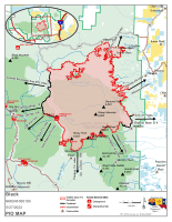
Firefighters working day and night to contain the Black FireCritical fire weather anticipated through the weekend Acres: 191,459 acres Location: 31 miles NW of Truth or Consequences Containment: 13% Personnel: 784 Start Date: Friday, May 13, 2022 Cause: Human-caused, under investigation Fuels: Timber and tall grass Structures Lost: 2 Overview: The Black Fire has over […]
Continue readingBlack Fire Daily Update: 5/26/22
May 26, 2022 0 Comments
Acres: 179,539 acres Containment: 13% Location: 31 miles NW of Truth or Consequences Personnel: 777 Structures Lost: 2 Fuels: Timber and tall grass Cause: Human-caused, under investigation Overview: Personnel conducted firing operations along Turkey Creek Road to keep the fire south of State Highway 59 and west of State Highway 52. The rugged nature, inaccessible […]
Continue readingFinal Update: Bear Fire, Lincoln National Forest Sacramento Ranger District
May 23, 2022 0 Comments
Incident Name – Bear Fire Jurisdiction: Forest Service, Sacramento Ranger District Size: 6 acres Cause: Unknown Date/Time Detected: May 23, 2022, around 5 pm. Location: Off Bear Canyon Road near where it intersects Highway 130. North of Camp of the Tall Pines. Firefighting Resources: County and Forest Service firefighting resources: 3 engines. Single Engine Airtanker. Air attack. […]
Continue readingNew Fire Start: Bear Fire – Lincoln National Forest, Sacramento Ranger District
May 23, 2022 0 Comments
Incident Name – Bear Fire Jurisdiction: Forest Service, Sacramento Ranger District Size: 3 acres Cause: Unknown Date/Time Detected: May 23, 2022, around 5 pm. Location: Off Bear Canyon Road near where it intersects Highway 130. North of Camp of the Tall Pines. Firefighting Resources: County and Forest Service firefighting resources: 3 engines. Air attack launched. Fire Update […]
Continue reading


