
Jurisdiction: State/Private and Lincoln National Forest Size: 17 acres Cause: Human Caused, Structure Fire Date/Time Detected: 8:30pm Feb. 5, 2021 Location: Near Hay Canyon Rd and Agua Chiquita Rd (near Sacramento, NM) Firefighting Resources: 2 Type-6 engines, numerous volunteer fire departments, miscellaneous personnel. Additional resource including personnel, a bulldozer and water tenders have been ordered and […]
Continue reading
Archive by Author
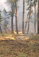

New Start-Lincoln National Forest-Spring Fire near Sacramento, NM.
 February 5, 2021
  0 Comments
The Spring Fire Jurisdiction: Private Land and Lincoln National Forest Size: 5 acres Cause: Human Caused Date/Time Detected: 8:30 pm Feb. 5, 2021 Location: Spring Canyon, near Sacramento Firefighting Resources: 2 Type-6 engines, numerous volunteer fire departments, miscellaneous personnel. Fuel Type: Ponderosa pine, grasses Values at Risk: Structures near Sacramento Fire Update: The Spring Fire began as […]
Continue readingOtero County Slash Pit Burn Scheduled Today
January 20, 2021 0 Comments
The Otero County slash pit will be burned today, Wednesday, January 20, 2021. The Slash Pit is located off Highway 244 northeast of Cloudcroft, NM. Smoke will be visible from Cloudcroft and along Highway 82 and Highway 244. Please use extra caution while driving in smoky conditions. The Slash Pit is co-operated by Otero County […]
Continue readingOtero County Slash Pit Burn Scheduled Next Week
January 13, 2021 0 Comments
The Otero County Slash Pit located northeast of Cloudcroft, NM on Highway 244 is scheduled to be burned next week on Tuesday, January 20 or Wednesday, January 21, depending on conditions. Smoke will be visible from Cloudcroft and along nearby roadways. Please use extra caution when driving in smoky conditions. The Slash Pit is managed […]
Continue readingLincoln National Forest- Smoke Visible from Capitan, Carrizozo
September 4, 2020 0 Comments
Smoke from the Dark Canyon Fire is visible from the Carrizozo and Capitan areas. The smoke is from an interior pocket of fuel burning within the fire perimeter. Fire crews are aware of the fire activity and are monitoring the situation.
Continue readingAble Fire Update, August 24, 2020: Lincoln National Forest, Sacramento Ranger District
August 24, 2020 0 Comments
Incident Name – Able Fire Jurisdiction: Lincoln National Forest, Sacramento Ranger District Size: 8 acres Cause: Lightning Date/Time Detected: August 18, 2020 Location: Scott Able Canyon, New Mexico Lat/Long: Example 32°42’56.0″N / 105°43’53.0″W Firefighting Resources: 2 Type 6-Engines and support personnel Fuel Type: Grass, pine and juniper forest Values at Risk: None Fire Update: Yesterday, firefighters brought ample water to increase […]
Continue readingAble Fire Update: August 23, 2020. Lincoln National Forest, Sacramento Ranger District
August 23, 2020 0 Comments
Incident Name – Able Fire Jurisdiction: Lincoln National Forest, Sacramento Ranger District Size: 8 acres Cause: Lightning Date/Time Detected: August 18, 2020 Location: Scott Able Canyon, New Mexico Lat/Long: Example 32°42’56.0″N/105°43’53.0″W Firefighting Resources: 1 Type-6 Engine,1 hand crew and fire support Fuel Type: Grass, pine and juniper forest Values at Risk: None Fire Update: Conditions on the Able Fire are winding […]
Continue readingAble Fire Update, August 22, 2020: Lincoln National Forest, Sacramento Ranger District
August 22, 2020 0 Comments
Incident Name – Able Fire Jurisdiction: Lincoln National Forest, Sacramento Ranger District Size: 8 acres Cause: Lightning Date/Time Detected: August 18, 2020 Location: Scott Able Canyon, New Mexico Lat/Long: Example 32°42’56.0″N/105°43’53.0″W Firefighting Resources: 1 Type-6 Engine, 1 Hand Crew and Fire Support Fuel Type: grass, pine and juniper forest Values at Risk: None Fire Update: The Able Fire received periodic moisture […]
Continue readingDark Canyon Fire Final Update, August 21, 2020: Lincoln National Forest, Sacramento Ranger District
August 21, 2020 0 Comments
Incident Name – Dark Canyon Fire Jurisdiction: Lincoln National Forest, Sacramento Ranger District Size: 3,070 acres Cause: Lightning Date/Time Detected: August 4, 2020 Location: 9 miles northwest of Capitan, NM, near Dark Canyon Lat/Long: Example 33°40’0.16 N / 105°37”42.61″W Firefighting Resources: 1 Type-6 Engine Values at Risk: None Fire Update: Fire activity on the Dark Canyon Fire is low with the […]
Continue readingAble Fire Update, August 21, 2020: Lincoln National Forest, Sacramento Ranger District
August 21, 2020 0 Comments
Incident Name – Able Fire Jurisdiction: Lincoln National Forest, Sacramento Ranger District Size: 8 acres Cause: Lightning Date/Time Detected: August 18, 2020 Location: Scott Able Canyon, New Mexico Lat/Long: Example 32°42’56.0″N 105°43’53.0W” Firefighting Resources: 1 Type-6 Engine, 1 hand crew and support personnel Total Personnel: 18 Fuel Type: Grass, pine and juniper forest Values at Risk: None Fire Update: Firefighters took advantage of […]
Continue readingAble Fire Update, August 20, 2020: Lincoln National Forest, Sacramento Ranger District
August 20, 2020 0 Comments
Incident Name: Able Fire Jurisdiction: Sacramento Ranger District, Lincoln National Forest Size: 8 acres Cause: Lightning Date Detected: August 18, 2020 Location: near Scott Able Canyon Lat/Long: 32°42’56.0″N 105°43’53.0″W Firefighting Resources: 1 Type-6 Engine, 1 hand crew, support personnel (16 total personnel) Fuel Type: grass, pine and juniper forest Values at Risk: no structures at […]
Continue readingDark Canyon Fire Update-August 19, 2020: Containment Jumps to 45%
August 19, 2020 0 Comments
Size: 3,030 acres Containment: 45% Cause: Lightning Location: 9 miles northwest of Capitan, NM near Dark Canyon Total Personnel: 25 Lat/Long: 33°40’0.16″N 105°37’42.61″W Fuel Type: Grass, piñon-juniper, ponderosa pine, dead and down forest debris Date/Time Detected: 8/4/20 at 4:30 pm Fire Update: A large interior pocket of unburned fuel on the east side of the […]
Continue readingLincoln National Forest: New Fire Start Near Scott Abel Canyon
August 18, 2020 0 Comments
Jurisdiction: Sacramento Ranger District, Lincoln National Forest Size: 0.25 acre Cause: Lightning Date Detected: 8/18/20 Location: In the vicinity of Scott Abel Canyon Fuel Type: Mix Conifer Values at Risk: Unknown Fire Update: Firefighters are responding to a 0.25-acre fire in the vicinity of Scott Abel Canyon. Smoke is visible from Timberon, NM. More information will be […]
Continue readingDark Canyon Fire Update: August 17, 2020
August 17, 2020 0 Comments
Size: 2,527 acres Containment: 10% Cause: Lightning Location: 9 miles northwest of Capitan, NM Total Personnel: 45 Lat/Long: 33°40’0.16″N 105°37’42.61″W Fuel Type: Grass, piñon-juniper, ponderosa pine, dead and down forest debris Date/Time Detected: 8/4/20 at 4:30 pm Dark Canyon Fire Maps Fire Update: On Sunday, the Dark Canyon Fire received up to ¼ inch of […]
Continue readingDark Canyon Fire Update August 15, 2020: Firing Operations Planned for Today
August 15, 2020 0 Comments
Size: 1,509 acres Containment: 10% Cause: Lightning Location: 9 miles northwest of Capitan, NM Total Personnel: 120 Lat/Long: 33°40’0.16″N 105°37’42.61″W Fuel Type: Grass, piñon-juniper, ponderosa pine, dead and down forest debris Date/Time Detected: 8/4/20 at 4:30 pm Dark Canyon Fire Maps Fire Update: The Dark Canyon Fire received light precipitation yesterday afternoon moderating fire activity. […]
Continue readingDark Canyon Fire Update August 13, 2020: Fire Grows In Size But Is Still Within Suppression Strategy Area
August 13, 2020 0 Comments
Size: 1,324 acres Containment: 10% Cause: Lightning Location: 9 miles northwest of Capitan, NM Total Personnel: 120 Lat/Long: 33°40’0.16″N 105°37’42.61″W Fuel Type: Grass, piñon-juniper, ponderosa pine, dead and down forest debris Date/Time Detected: 8/4/20 at 4:30 pm Dark Canyon Fire Maps Fire Update: The Dark Canyon Fire remains within the Suppression Strategy Area and is […]
Continue reading Lincoln National Forest: Dark Canyon Fire Update August 9, 2020
August 9, 2020 0 Comments
Jurisdiction: Smokey Bear Ranger District, Lincoln National Forest Size: 420 acres Cause: Lightning Date/Time Detected: August 4, 2020 at 4:30pm Location: 9 miles northwest of Capitan, NM north of Tuscon Mountain near Dark Canyon. Lat/Long: 33°40’0.16″N 105°37’42.61″W Fuel Type: Grass, piñon-juniper, ponderosa pine, dead and down forest debris Values at Risk: Private Land Fire Update: Crews […]
Continue reading Lincoln National Forest: Dark Canyon Fire Update August 8, 2020: Crew Conduct Firing Operations
August 8, 2020 0 Comments
Jurisdiction: Smokey Bear Ranger District, Lincoln National Forest Size: 300 acres Cause: Lightning Date/Time Detected: August 4, 2020 at 4:30pm Location: 9 miles northwest of Capitan, NM north of Tuscon Mountain near Dark Canyon. Lat/Long: 33°40’0.16″N 105°37’42.61″W Fuel Type: Grass, piñon-juniper, ponderosa pine, dead and down forest debris Values at Risk: Private Land Dark Canyon Fire […]
Continue readingLincoln National Forest: Dark Canyon Fire Update August 7, 2020
August 7, 2020 0 Comments
Dark Canyon Fire Jurisdiction: Smokey Bear Ranger District, Lincoln National Forest Size: 300 acres Cause: Lightning Date/Time Detected: August 4, 2020 at 4:30pm Location: 9 miles northwest of Capitan, NM north of Tuscon Mountain near Dark Canyon. Lat/Long: 33°40’0.16″N 105°37’42.61″W Fuel Type: Grass, piñon-juniper, ponderosa pine, dead and down forest debris Values at Risk: Private Land […]
Continue readingLincoln National Forest: Dark Canyon Fire Update August 6, 2020
August 6, 2020 0 Comments
Incident Name: Dark Canyon Fire Jurisdiction: Smokey Bear Ranger District, Lincoln National Forest Size: 30 acres Cause: Lightning Date/Time Detected: August 4, 2020 at 4:30pm Location: 9 miles northwest of Capitan, NM north of Tuscon Mountain near Dark Canyon. Lat/Long: 33°40’0.16″N 105°37’42.61″W Fuel Type: Grass, piñon-juniper, ponderosa pine, dead and down forest debris Values at Risk: […]
Continue reading


