
Thursday, June 10, 2021 Visit the New Mexico Fire Information website at http://www.nmfireinfo.com Inciweb: https://inciweb.nwcg.gov/incident/7493/ Fire Phone 575-519-0103 JOHNSON FIRE Location: Johnson Canyon, west of McKenna Park. 11 miles west of Gila Cliff Dwellings, Wilderness Ranger District, Catron County, NM Start Date: May 20, 2021 Size: ~ 46,790 Cause: […]
Continue reading
Archive | Smoke RSS feed for this section

Three Rivers Fire Update – May 13, 2021
 May 13, 2021
  0 Comments
Updates will now be released every other day unless there is a significant change to report. Acres: 7,040 acres Containment: 50% Vegetation: Grass, dead/down timber, and mixed conifer. Start Date: April 26, 2021 Cause: Unknown, Under Investigation Origin Location: ½ mile north of Three Rivers Campground; fire spread towards Ski Apache and the South Fork/Bonito area. Ruidoso, New Mexico, May […]
Continue readingThree Rivers Fire Update – May 11, 2021
May 11, 2021 0 Comments
Updates will now be released every other day unless there is a significant change. Acres: 7,040 acres Containment: 50% Vegetation: Grass, dead/down timber, and mixed conifer. Start Date: April 26, 2021 Cause: Unknown, Under Investigation Origin Location: ½ mile north of Three Rivers Campground; fire spread towards Ski Apache and the South Fork/Bonito area. Ruidoso, New Mexico, May 11, 2021 – On Sunday, May […]
Continue readingThree Rivers Fire Update – May 4, 2021
May 4, 2021 0 Comments
Acres: 7,020 acres Containment: 23% Resources: 284 Vegetation: Grass, dead/down timber, and mixed conifer. Start Date: April 26, 2021: 8:00 am Cause: Unknown, Under Investigation Origin Location: ½ mile north of Three Rivers Campground; fire has spread towards both Ski Apache and the South Fork/Bonito area. Ruidoso, New Mexico, May 4, 2021 – Moderate winds […]
Continue readingThree Rivers Fire Update – May 3, 2021
May 3, 2021 0 Comments
Acres: 7,119 Percent Containment: 23% Date/Time Detected: 8:42 am, April 26, 2021 Resources: 317 Vegetation: Grass, dead/down timber, mixed conifer Cause: Unknown, under investigation Origin/Location: ½ mile north of Three Rivers Ruidoso, New Mexico, March 3, 2021 – Strong wind gusts yesterday tested the fire lines constructed by fire crews over the past several days. […]
Continue readingThree Rivers Fire – Weather & Fire Behavior
May 2, 2021 0 Comments
Ruidoso, New Mexico, May 2, 2021 – Dan Pearson, Three Rivers Fire Behavior Analyst, is responsible forcollecting weather data, predicting fire growth, and developing strategic and tactical fire behaviorinformation. He looks at the interaction of topography, fuels, and weather to determine what the fire’s effectswill be. All this critical information is used by incident managers […]
Continue readingThree Rivers Fire Update – May 2, 2021
May 2, 2021 0 Comments
Acres: 7,119 Percent Containment: 19% Date/Time Detected: 8:42 am, April 26, 2021 Resources: 337 Vegetation: Grass, dead/down timber, mixed conifer Cause: Unknown, under investigation Origin/Location: ½ mile north of Three Rivers Ruidoso, New Mexico, March 2, 2021 – A Red Flag Warning has been issued by the National Weather Service for today. This means warm […]
Continue readingBLM plans prescribed fire in Catron County
November 6, 2020 0 Comments
Beginning November 15, and continuing through the end of 2020, the Bureau of Land Management Socorro Field Office plans to burn piles of juniper and piñon cuttings in three locations in Catron County, weather permitting. Details on each location and size are as follows: Pie Town Pile Burn – 196 acres, located one mile west […]
Continue readingDark Canyon Fire Final Update, August 21, 2020: Lincoln National Forest, Sacramento Ranger District
August 21, 2020 0 Comments
Incident Name – Dark Canyon Fire Jurisdiction: Lincoln National Forest, Sacramento Ranger District Size: 3,070 acres Cause: Lightning Date/Time Detected: August 4, 2020 Location: 9 miles northwest of Capitan, NM, near Dark Canyon Lat/Long: Example 33°40’0.16 N / 105°37”42.61″W Firefighting Resources: 1 Type-6 Engine Values at Risk: None Fire Update: Fire activity on the Dark Canyon Fire is low with the […]
Continue readingAble Fire Update, August 21, 2020: Lincoln National Forest, Sacramento Ranger District
August 21, 2020 0 Comments
Incident Name – Able Fire Jurisdiction: Lincoln National Forest, Sacramento Ranger District Size: 8 acres Cause: Lightning Date/Time Detected: August 18, 2020 Location: Scott Able Canyon, New Mexico Lat/Long: Example 32°42’56.0″N 105°43’53.0W” Firefighting Resources: 1 Type-6 Engine, 1 hand crew and support personnel Total Personnel: 18 Fuel Type: Grass, pine and juniper forest Values at Risk: None Fire Update: Firefighters took advantage of […]
Continue readingAble Fire Update, August 20, 2020: Lincoln National Forest, Sacramento Ranger District
August 20, 2020 0 Comments
Incident Name: Able Fire Jurisdiction: Sacramento Ranger District, Lincoln National Forest Size: 8 acres Cause: Lightning Date Detected: August 18, 2020 Location: near Scott Able Canyon Lat/Long: 32°42’56.0″N 105°43’53.0″W Firefighting Resources: 1 Type-6 Engine, 1 hand crew, support personnel (16 total personnel) Fuel Type: grass, pine and juniper forest Values at Risk: no structures at […]
Continue readingDark Canyon Fire Update-August 19, 2020: Containment Jumps to 45%
August 19, 2020 0 Comments
Size: 3,030 acres Containment: 45% Cause: Lightning Location: 9 miles northwest of Capitan, NM near Dark Canyon Total Personnel: 25 Lat/Long: 33°40’0.16″N 105°37’42.61″W Fuel Type: Grass, piñon-juniper, ponderosa pine, dead and down forest debris Date/Time Detected: 8/4/20 at 4:30 pm Fire Update: A large interior pocket of unburned fuel on the east side of the […]
Continue readingLincoln National Forest: New Fire Start Near Scott Abel Canyon
August 18, 2020 0 Comments
Jurisdiction: Sacramento Ranger District, Lincoln National Forest Size: 0.25 acre Cause: Lightning Date Detected: 8/18/20 Location: In the vicinity of Scott Abel Canyon Fuel Type: Mix Conifer Values at Risk: Unknown Fire Update: Firefighters are responding to a 0.25-acre fire in the vicinity of Scott Abel Canyon. Smoke is visible from Timberon, NM. More information will be […]
Continue readingDark Canyon Fire Update August 15, 2020: Firing Operations Planned for Today
August 15, 2020 0 Comments
Size: 1,509 acres Containment: 10% Cause: Lightning Location: 9 miles northwest of Capitan, NM Total Personnel: 120 Lat/Long: 33°40’0.16″N 105°37’42.61″W Fuel Type: Grass, piñon-juniper, ponderosa pine, dead and down forest debris Date/Time Detected: 8/4/20 at 4:30 pm Dark Canyon Fire Maps Fire Update: The Dark Canyon Fire received light precipitation yesterday afternoon moderating fire activity. […]
Continue reading Lincoln National Forest: Dark Canyon Fire Update August 8, 2020: Crew Conduct Firing Operations
August 8, 2020 0 Comments
Jurisdiction: Smokey Bear Ranger District, Lincoln National Forest Size: 300 acres Cause: Lightning Date/Time Detected: August 4, 2020 at 4:30pm Location: 9 miles northwest of Capitan, NM north of Tuscon Mountain near Dark Canyon. Lat/Long: 33°40’0.16″N 105°37’42.61″W Fuel Type: Grass, piñon-juniper, ponderosa pine, dead and down forest debris Values at Risk: Private Land Dark Canyon Fire […]
Continue readingLincoln National Forest: Dark Canyon Fire Update August 7, 2020
August 7, 2020 0 Comments
Dark Canyon Fire Jurisdiction: Smokey Bear Ranger District, Lincoln National Forest Size: 300 acres Cause: Lightning Date/Time Detected: August 4, 2020 at 4:30pm Location: 9 miles northwest of Capitan, NM north of Tuscon Mountain near Dark Canyon. Lat/Long: 33°40’0.16″N 105°37’42.61″W Fuel Type: Grass, piñon-juniper, ponderosa pine, dead and down forest debris Values at Risk: Private Land […]
Continue readingLincoln National Forest: Dark Canyon Fire Update August 6, 2020
August 6, 2020 0 Comments
Incident Name: Dark Canyon Fire Jurisdiction: Smokey Bear Ranger District, Lincoln National Forest Size: 30 acres Cause: Lightning Date/Time Detected: August 4, 2020 at 4:30pm Location: 9 miles northwest of Capitan, NM north of Tuscon Mountain near Dark Canyon. Lat/Long: 33°40’0.16″N 105°37’42.61″W Fuel Type: Grass, piñon-juniper, ponderosa pine, dead and down forest debris Values at Risk: […]
Continue readingGila National Forest: McMillan Fire – Silver City Ranger District
August 5, 2020 0 Comments
Location: Northwest of McMillan Campground, Silver City Ranger District, Gila National Forest Start Date: August 4, 2020 Cause: Lightning Size: ~1 acre Vegetation: Mixed conifer Resources: Silver City RD engines have responded Summary: The McMillan Fire is burning northwest of McMillan Campground, approximately one mile below Signal Peak between the campground and the Signal Peak […]
Continue readingCibola National Forest & National Grasslands – Final Fire Update -Vics Peak Fire 100% Contained
August 4, 2020 0 Comments
Magdalena, NM – For Immediate Release – The lightning-caused Vics Peak Fire, burning on the Magdalena Ranger District, Cibola National Forest since June 15, remains 14,624 acres and is now 100% contained. This will be the final operational update for the Vics Peak Fire barring any significant events on the fire. Minimal fire behavior was observed […]
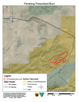
Continue reading BLM prescribed burn planned in Lincoln County
July 30, 2020 0 Comments
Beginning in August, the Bureau of Land Management (BLM) will be conducting prescribed burn operations about 10 miles northeast of Ruidoso and 6 miles southeast of Capitan in Lincoln County. The 206-acre Pershing slash pile unit is located within the Fort Stanton-Snowy River Cave National Conservation Area. This operation is weather dependent and will take […]
Continue reading


